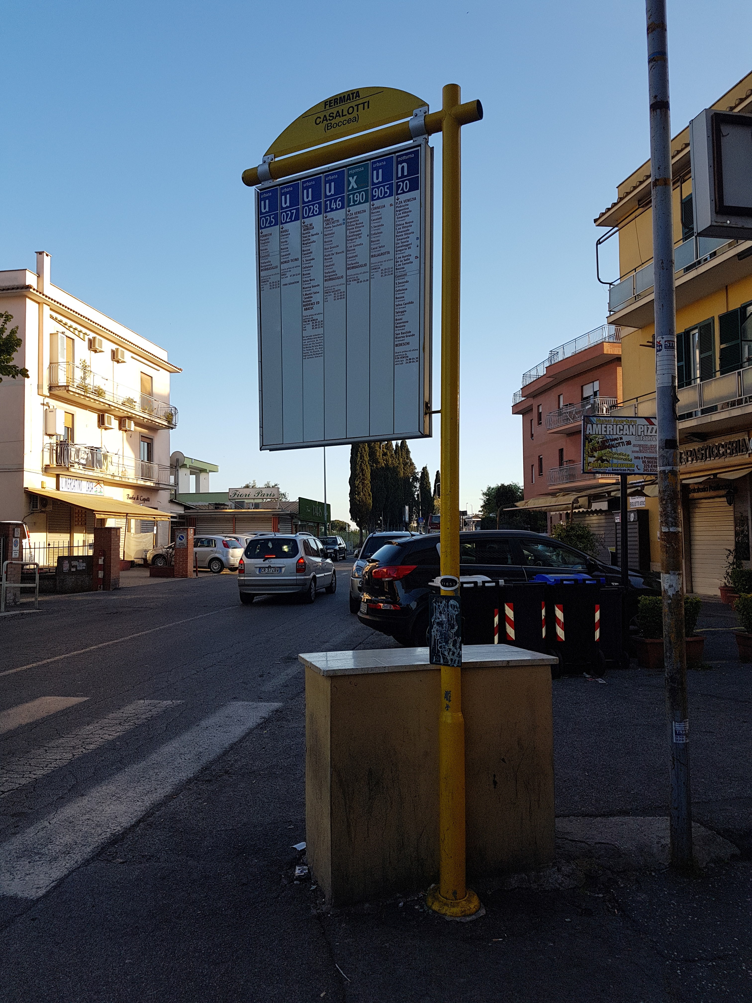
Casalotti/Boccea stop - Thursday schedule
| Line | Direction | Time |
|---|---|---|
| N904 | Piazza Venezia | 3:03 AM |
| N904 | Piazza Venezia | 3:03 AM |
| N904 | Piazza Venezia | 3:50 AM |
| N904 | Piazza Venezia | 3:50 AM |
| N904 | Piazza Venezia | 5:00 AM |
| N904 | Piazza Venezia | 5:00 AM |
| 905 | Malagrotta | 5:22 AM |
| 146 | Mombasiglio | 5:41 AM |
| 905 | Malagrotta | 5:44 AM |
| 028 | San Basilide | 5:46 AM |
| 146 | Mombasiglio | 5:56 AM |
| 025 | Mombasiglio | 6:01 AM |
| 905 | Malagrotta | 6:06 AM |
| 146 | Mombasiglio | 6:11 AM |
| 028 | San Basilide | 6:21 AM |
| 146 | Mombasiglio | 6:24 AM |
| 905 | Malagrotta | 6:28 AM |
| 146 | Mombasiglio | 6:38 AM |
| 025 | Mombasiglio | 6:43 AM |
| 905 | Malagrotta | 6:53 AM |
| 028 | San Basilide | 6:55 AM |
| 146 | Mombasiglio | 6:56 AM |
| 146 | Mombasiglio | 7:12 AM |
| 025 | Mombasiglio | 7:18 AM |
| 905 | Malagrotta | 7:18 AM |
Directions to Casalotti/Boccea stop (Roma) with public transit
The following transit lines have routes that pass near Casalotti/Boccea
 Bus: 146, 904, 905, N904, 025.
- Metro: A.
How to get to Casalotti/Boccea stop by bus?
Click on the bus route to see step by step directions with maps, line arrival times and updated time schedules.
How to get to Casalotti/Boccea stop by metro?
Click on the metro route to see step by step directions with maps, line arrival times and updated time schedules.
Bus stops near Casalotti/Boccea stop in Roma
- Boccea/Candelo, 2 min walk,
- Boccea/Casalotti, 3 min walk,
- Casal Del Marmo/Bernezzo, 3 min walk,
- Casalotti/Borgo Ticino, 4 min walk,
- Casalotti/Boccea, 4 min walk,
- Casalotti/Clovio, 5 min walk,
Metro stations near Casalotti/Boccea station in Roma
- Battistini, 12 min walk,
Bus lines to Casalotti/Boccea stop in Roma
- N904, Bedeschi,
- 025, Mombasiglio,
- 031, La Giustiniana Station,
- 904, Bedeschi,
- 908, Grondona,
- 993, Cornelia Metro A,
- 190F, Piazza Venezia,
- 905, Cornelia (MA),
- 028, San Basilide,
- 146, Mombasiglio,
- 91, Battistini/Soria,
- 027, Borgo Ticino,
What are the closest stations to Casalotti/Boccea?
The closest stations to Casalotti/Boccea are:
- Boccea/Candelo stop is 102 meters away, 2 min walk.
- Boccea/Casalotti stop is 159 meters away, 3 min walk.
- Casal Del Marmo/Bernezzo stop is 233 meters away, 3 min walk.
- Casalotti/Borgo Ticino stop is 305 meters away, 4 min walk.
- Casalotti/Boccea stop is 312 meters away, 4 min walk.
- Casalotti/Clovio stop is 376 meters away, 5 min walk.
- Battistini station is 897 meters away, 12 min walk.
Which bus lines stop near Casalotti/Boccea?
These bus lines stop near Casalotti/Boccea: 146, 904, 905.
Which metro line stops near Casalotti/Boccea?
A (Battistini)
What’s the nearest metro station to Casalotti/Boccea in Roma?
The nearest metro station to Casalotti/Boccea in Roma is Battistini. It’s a 12 min walk away.
What’s the nearest bus station to Casalotti/Boccea in Roma?
The nearest bus station to Casalotti/Boccea in Roma is Boccea/Candelo. It’s a 2 min walk away.
What time is the first metro to Casalotti/Boccea in Roma?
The A is the first metro that goes to Casalotti/Boccea in Roma. It stops nearby at 5:30 AM.
What time is the last metro to Casalotti/Boccea in Roma?
The A is the last metro that goes to Casalotti/Boccea in Roma. It stops nearby at 12:11 AM.
What time is the first bus to Casalotti/Boccea in Roma?
The N904 is the first bus that goes to Casalotti/Boccea in Roma. It stops nearby at 3:02 AM.
What time is the last bus to Casalotti/Boccea in Roma?
The N904 is the last bus that goes to Casalotti/Boccea in Roma. It stops nearby at 3:12 AM.
Casalotti/Boccea station
 Taken by mimmo a.
See Casalotti/Boccea stop, Roma, on the map
Public transit to Casalotti/Boccea stop (ID: 71653) in Roma
Looking for directions to Casalotti/Boccea in Roma, Italy?
Download the Moovit App to find the current schedule and step-by-step directions for Bus or Metro routes that pass through Casalotti/Boccea.
Looking for the nearest stops closest to Casalotti/Boccea ? Check out this list of closest stops to your destination: Boccea/Candelo; Boccea/Casalotti; Casal Del Marmo/Bernezzo; Casalotti/Borgo Ticino; Casalotti/Boccea; Casalotti/Clovio; Battistini.
Bus: 146, 904, 905, N904, 025, 031, 908, 993, 190F, 028, 91.Metro: A.
We make riding on public transit to Casalotti/Boccea easy, which is why over 1.7 billion users, including users in Roma trust Moovit as the best app for public transit.
Use the app to navigate to popular places including to the airport, hospital, stadium, grocery store, mall, coffee shop, school, college, and university.
Casalotti/Boccea stop’s code is 71653
The first line to this stop is N904, at 3:03 AM, and the last line is N904 at 2:18 AM.
This stop serves ATAC and BIS’s lines
Popular routes from Casalotti/Boccea stop, Roma
- Boccea/Candelo,
- Boccea/Casalotti,
- Casal Del Marmo/Bernezzo,
- Casalotti/Borgo Ticino,
- Casalotti/Boccea,
- Casalotti/Clovio
Bus stops near Casalotti/Boccea stop
- Battistini
Metro station near Casalotti/Boccea station
- Vimercati/Ateneo Salesiano,
- Verano,
- Nettuno,
- Collatina/Tor Sapienza (FL2),
- Oderisi Da Gubbio/Grimaldi,
- Casilina/Torre Maura,
- Saxa Rubra Station,
- Vittorio Emanuele Course/Argentina,
- Saint Peter Station Square,
- Sabaudia | Migliara 53 Road Pontina Road,
- Fara Sabina | Campo Maggiore,
- Villa Cavalletti (School Institute),
- Sacred Cave Monastery - Subiaco,
- Livorno,
- Rieti | Salaria Road (Km 67),
- Arcinazzo | Highlands,
- Biopark,
- Longoni/Inps,
- Sermoneta | Pontenuovo,
- Romagnoli/Talenti
Popular public transit stations in Roma
Get around Roma by public transit!
Traveling around Roma has never been so easy. See step by step directions as you travel to any attraction, street or major public transit station. View bus and train schedules, arrival times, service alerts and detailed routes on a map, so you know exactly how to get to anywhere in Roma.
When traveling to any destination around Roma use Moovit's Live Directions with Get Off Notifications to know exactly where and how far to walk, how long to wait for your line, and how many stops are left. Moovit will alert you when it's time to get off — no need to constantly re-check whether yours is the next stop.
Wondering how to use public transit in Roma or how to pay for public transit in Roma? Moovit public transit app can help you navigate your way with public transit easily, and at minimum cost. It includes public transit fees, ticket prices, and costs. Looking for a map of Roma public transit lines? Moovit public transit app shows all public transit maps in Roma with all Bus, Train, Metro, Light Rail, Ferry, Funicular and Gondola routes and stops on an interactive map.
Rome and Lazio has 7 transit type(s), including: Bus, Train, Metro, Light Rail, Ferry, Funicular and Gondola, operated by several transit agencies, including ATAC, Cotral, Trenitalia, Troiani Transportation Services, BIS, ATR Mobility, Tuscia, Shuttle, Seatour, Troiani Bus Lines, CSC Mobility, Terravision, ATRAL, Tambus and Sitbus