Casetta Mattei/Conte stop - Monday schedule
| Line | Direction | Time |
|---|---|---|
| N98 | Mazzacurati | 3:20 AM |
| N98 | Mazzacurati | 3:20 AM |
| N98 | Mazzacurati | 4:00 AM |
| N98 | Mazzacurati | 4:00 AM |
| N98 | Mazzacurati | 4:40 AM |
| N98 | Mazzacurati | 4:40 AM |
| N98 | Mazzacurati | 5:20 AM |
| N98 | Mazzacurati | 5:20 AM |
| 98 | Mazzacurati | 5:45 AM |
| 98 | Mazzacurati | 5:56 AM |
| 98 | Mazzacurati | 6:07 AM |
| 98 | Mazzacurati | 6:18 AM |
| 889 | Mazzacurati | 6:24 AM |
| 889 | Mazzacurati | 6:35 AM |
| 98 | Mazzacurati | 6:37 AM |
| 98 | Mazzacurati | 6:48 AM |
| 889 | Mazzacurati | 6:49 AM |
| 98 | Mazzacurati | 6:57 AM |
| 889 | Mazzacurati | 7:04 AM |
| 98 | Mazzacurati | 7:06 AM |
| 98 | Mazzacurati | 7:15 AM |
| 889 | Mazzacurati | 7:17 AM |
| 98 | Mazzacurati | 7:28 AM |
| 889 | Mazzacurati | 7:31 AM |
| 98 | Mazzacurati | 7:44 AM |
Directions to Casetta Mattei/Conte stop (Roma) with public transit
The following transit lines have routes that pass near Casetta Mattei/Conte
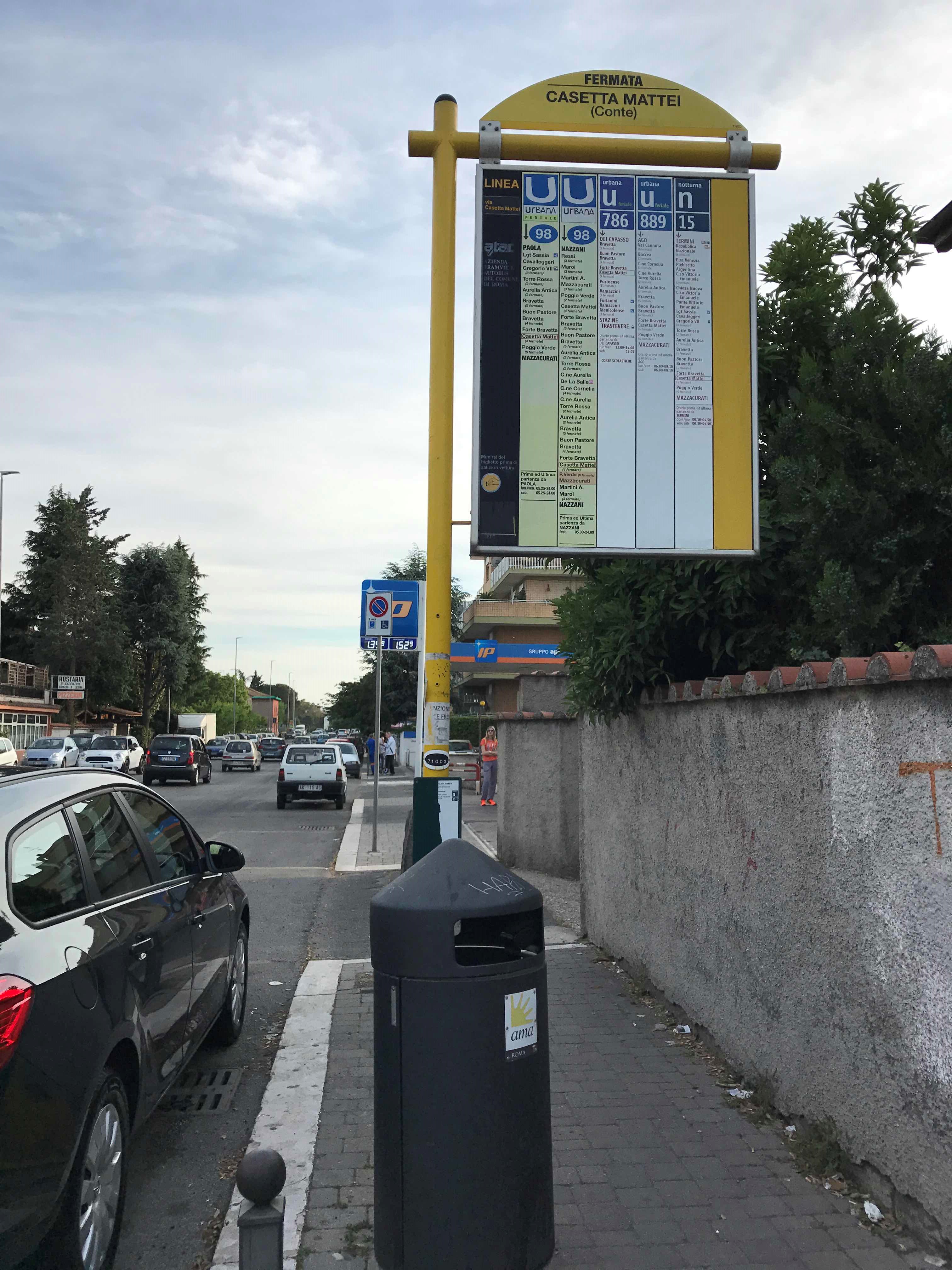
 Bus: 889, 98, N98, 96, 786.
- Train: FL3, FL1, FL5.
How to get to Casetta Mattei/Conte stop by bus?
Click on the bus route to see step by step directions with maps, line arrival times and updated time schedules.
Bus stops near Casetta Mattei/Conte stop in Roma
- Bravetta/Marcellini, 1 min walk,
- Poggio Verde/Casetta Mattei, 4 min walk,
Train stations near Casetta Mattei/Conte station in Roma
- Quattro Venti, 42 min walk,
- Bonelli Villa, 49 min walk,
Bus lines to Casetta Mattei/Conte stop in Roma
- 98, Paola,
- N98, Mazzacurati,
- 889, Val Cannuta/Conforti,
- 96, Corviale - Ostiense (MB-RL-FS),
- 786, Trastevere (Railway) - Corviale,
What are the closest stations to Casetta Mattei/Conte?
The closest stations to Casetta Mattei/Conte are:
- Bravetta/Marcellini stop is 28 meters away, 1 min walk.
- Poggio Verde/Casetta Mattei stop is 256 meters away, 4 min walk.
- Quattro Venti station is 3287 meters away, 42 min walk.
- Bonelli Villa station is 3881 meters away, 49 min walk.
Which bus lines stop near Casetta Mattei/Conte?
These bus lines stop near Casetta Mattei/Conte: 889, 98.
What’s the nearest bus station to Casetta Mattei/Conte in Roma?
The nearest bus station to Casetta Mattei/Conte in Roma is Bravetta/Marcellini. It’s a 1 min walk away.
What time is the first train to Casetta Mattei/Conte in Roma?
The FL1 is the first train that goes to Casetta Mattei/Conte in Roma. It stops nearby at 5:25 AM.
What time is the last train to Casetta Mattei/Conte in Roma?
The FL1 is the last train that goes to Casetta Mattei/Conte in Roma. It stops nearby at 11:49 PM.
What time is the first bus to Casetta Mattei/Conte in Roma?
The N98 is the first bus that goes to Casetta Mattei/Conte in Roma. It stops nearby at 3:17 AM.
What time is the last bus to Casetta Mattei/Conte in Roma?
The N98 is the last bus that goes to Casetta Mattei/Conte in Roma. It stops nearby at 3:22 AM.
Casetta Mattei/Conte station
 Taken by Anonymous
See Casetta Mattei/Conte stop, Roma, on the map
Public transit to Casetta Mattei/Conte stop (ID: 71003) in Roma
Looking for directions to Casetta Mattei/Conte in Roma, Italy?
Download the Moovit App to find the current schedule and step-by-step directions for Bus or Metro routes that pass through Casetta Mattei/Conte.
Looking for the nearest stops closest to Casetta Mattei/Conte ? Check out this list of closest stops to your destination: Bravetta/Marcellini; Poggio Verde/Casetta Mattei; Quattro Venti; Bonelli Villa.
Bus: 889, 98, N98, 96, 786.Train: FL3, FL1, FL5.
We make riding on public transit to Casetta Mattei/Conte easy, which is why over 1.7 billion users, including users in Roma trust Moovit as the best app for public transit.
Use the app to navigate to popular places including to the airport, hospital, stadium, grocery store, mall, coffee shop, school, college, and university.
Casetta Mattei/Conte stop’s code is 71003
The first line to this stop is N98, at 3:20 AM, and the last line is N98 at 2:40 AM.
This stop serves ATAC and BIS’s lines
- Bravetta/Marcellini,
- Poggio Verde/Casetta Mattei
Bus stops near Casetta Mattei/Conte stop
- Quattro Venti,
- Bonelli Villa
Train stations near Casetta Mattei/Conte station
- Tuscolana/Arco Di Travertino,
- Grotta Perfetta/Ardeatina,
- Ciciliano | Empolitana Road (Km 15),
- Fregene | Sestri Levante Road,
- Camilluccia/De Amicis,
- Saxa Rubra (Rv),
- Settebagni/Vigne Nuove,
- Pincherle/Parravano,
- Nomentana Battery,
- Parioli/Acqua Acetosa,
- Muse,
- Emo/Di Bartolo,
- Vetralla | Campetta,
- Gianicolo Pass/Medical Center,
- Lucio Sestio (MA),
- Viterbo | Via Cimina (Barracks),
- Cerveteri, Furbara St Del Sasso St,
- Ardea | Laurentina Street Pontina Vecchia Street,
- Salaria/Motor Vehicle Department,
- Porta Furba
Popular public transit stations in Roma
Get around Roma by public transit!
Traveling around Roma has never been so easy. See step by step directions as you travel to any attraction, street or major public transit station. View bus and train schedules, arrival times, service alerts and detailed routes on a map, so you know exactly how to get to anywhere in Roma.
When traveling to any destination around Roma use Moovit's Live Directions with Get Off Notifications to know exactly where and how far to walk, how long to wait for your line, and how many stops are left. Moovit will alert you when it's time to get off — no need to constantly re-check whether yours is the next stop.
Wondering how to use public transit in Roma or how to pay for public transit in Roma? Moovit public transit app can help you navigate your way with public transit easily, and at minimum cost. It includes public transit fees, ticket prices, and costs. Looking for a map of Roma public transit lines? Moovit public transit app shows all public transit maps in Roma with all Bus, Train, Metro, Light Rail, Ferry, Funicular and Gondola routes and stops on an interactive map.
Rome and Lazio has 7 transit type(s), including: Bus, Train, Metro, Light Rail, Ferry, Funicular and Gondola, operated by several transit agencies, including ATAC, Cotral, Trenitalia, Troiani Transportation Services, BIS, ATR Mobility, Tuscia, Shuttle, Seatour, Troiani Bus Lines, CSC Mobility, Terravision, ATRAL, Tambus and Sitbus