How to get to Castelo de Chaves by bus?
Click on the bus route to see step by step directions with maps, line arrival times and updated time schedules.
From Quinta Do Seixo
114 minFrom Vila Real
128 minFrom Alijó
319 minFrom IMT
123 minFrom Nosso Shopping
133 minFrom Centro Hospitalar de Trás-os-Montes e Alto Douro - CHTMAD, E.P.E.
132 minFrom Universidade de Trás-os-Montes e Alto Douro (UTAD)
156 minFrom Naturwaterpark
128 minFrom Zona Industrial de Vila Real
229 min
Bus lines to Castelo de Chaves
What are the closest stations to Castelo de Chaves?
The closest stations to Castelo de Chaves are:
- Santo Amaro is 346 meters away, 5 min walk.
- Cemitério Velho is 579 meters away, 8 min walk.
Which bus lines stop near Castelo de Chaves?
These bus lines stop near Castelo de Chaves: IR004, IR005.
What’s the nearest bus station to Castelo de Chaves?
The nearest bus station to Castelo de Chaves is Santo Amaro. It’s a 5 min walk away.
See Castelo de Chaves on the map
Public Transportation to Castelo de Chaves
Wondering how to get to Castelo de Chaves? Moovit helps you find the best way to get to Castelo de Chaves with step-by-step directions from the nearest public transit station.
Moovit provides free maps and live directions to help you navigate through your city. View schedules, routes, timetables, and find out how long does it take to get to Castelo de Chaves in real time.
Looking for the nearest stop or station to Castelo de Chaves? Check out this list of stops closest to your destination: Santo Amaro; Cemitério Velho.
Bus: IR004, IR005, 01, 03, IM001, 02, IM004.
Want to see if there’s another route that gets you there at an earlier time? Moovit helps you find alternative routes or times. Get directions from and directions to Castelo de Chaves easily from the Moovit App or Website.
We make riding to Castelo de Chaves easy, which is why over 1.5 million users, including users in Chaves, trust Moovit as the best app for public transit. You don’t need to download an individual bus app or train app, Moovit is your all-in-one transit app that helps you find the best bus time or train time available.
For information on prices of bus and train, costs and ride fares to Castelo de Chaves, please check the Moovit app.
Use the app to navigate to popular places including to the airport, hospital, stadium, grocery store, mall, coffee shop, school, college, and university.
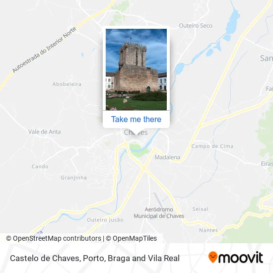
Castelo de Chaves Address: Praça de Camões 14 Chaves, 5400-150 Chaves street in Chaves

- Pastelaria Duchesse,
- Igreja de Jesus Cristo dos Santos dos 'Últimos Dias,
- Ecos - Escritório de Contabilidade, Organização e Serv.,
- Associação Flor do Tâmega Para Apoio a Deficientes,
- Frentevisão - Aconselhamento e Consultoria, Unipessoal,
- Sala Amarela - Indieror,
- Sítio Certo - Chaves,
- Adbs do Alto Tâmega,
- Chaves & Rivero,
- Salão Paris Cabeleireiro Masculino,
- Florista Transmontana,
- Damil - Imobiliária,
- Pelourinho de Monforte de Rio Livre,
- Igreja Matriz de Chaves,
- Agência Funerária Medeiros,
- Mess - Secretária Estado Emprego Formação Profissional - Inst. e,
- Capela de Nossa Senhora do Loreto,
- Ourivesaria Nobreza,
- Pelourinho da Praça da República,
- Maria Jose Teixeira de Freitas
Places Near Castelo de Chaves
- Hospital da Prelada, Ramalde,
- Avintes, Vila Nova De Gaia,
- VILA do CONDE PORTO FASHION OUTLET, Modivas,
- Acesso ao Shopping Parque Nascente, Campanhã,
- Maia, Maia,
- MAR Shopping, Matosinhos e Leça da Palmeira,
- Hospital Santos Silva, Vila Nova De Gaia,
- Senhor de Matosinhos, Matosinhos e Leça da Palmeira,
- Espinho, Espinho,
- Rua Calouste Gulbenkian, Lordelo do Ouro e Massarelos,
- Leça da Palmeira, Matosinhos e Leça da Palmeira,
- Canidelo, Vila Nova De Gaia,
- Valongo, Valongo,
- Parque Aquatico Amarante - Aqua Aventura, Amarante,
- Hospital de Santo António, Cedofeita, Santo Ildefonso, Sé, Miragaia, São Nicolau e Vitória,
- Estádio do Dragão, Campanhã,
- Zoo Santo Inácio, Vila Nova De Gaia,
- Palácio de Cristal, Lordelo do Ouro e Massarelos,
- Arrábida Shopping, Santa Marinha e São Pedro da Afurada,
- El Corte Inglés de Gaia, Mafamude e Vilar do Paraíso
How to get to popular places in Porto, Braga and Vila Real with public transit
Get around Chaves by public transit!
Traveling around Chaves has never been so easy. See step by step directions as you travel to any attraction, street or major public transit station. View bus and train schedules, arrival times, service alerts and detailed routes on a map, so you know exactly how to get to anywhere in Chaves.
When traveling to any destination around Chaves use Moovit's Live Directions with Get Off Notifications to know exactly where and how far to walk, how long to wait for your line, and how many stops are left. Moovit will alert you when it's time to get off — no need to constantly re-check whether yours is the next stop.
Wondering how to use public transit in Chaves or how to pay for public transit in Chaves? Moovit public transit app can help you navigate your way with public transit easily, and at minimum cost. It includes public transit fees, ticket prices, and costs. Looking for a map of Chaves public transit lines? Moovit public transit app shows all public transit maps in Chaves with all Bus, Train, Metro, Ferry, Funicular and Gondola routes and stops on an interactive map.
Porto, Braga and Vila Real has 6 transit type(s), including: Bus, Train, Metro, Ferry, Funicular and Gondola, operated by several transit agencies, including Metro do Porto, Metro do Porto - Metrobus, CP - Comboios de Portugal, STCP, UNIR Mobilidade da Area Metropolitana do Porto, Getbus - Aerobus, Mobiave, Valpibus, TUB - Transportes Urbanos de Braga, TuViana, Guimabus, Ave Mobilidade, Cávado Mobilidade, Transdev and Câmara Municipal de Santo Tirso