Cavalieri/Pasquariello stop - Monday schedule
| Line | Direction | Time |
|---|---|---|
| 88 | Labia | 5:23 AM |
| 88 | Labia | 5:38 AM |
| 93 | Monte San Giusto | 5:39 AM |
| 93 | Monte San Giusto | 5:52 AM |
| 88 | Labia | 5:53 AM |
| 88 | Labia | 5:58 AM |
| 93 | Monte San Giusto | 6:05 AM |
| 88 | Labia | 6:13 AM |
| 93 | Monte San Giusto | 6:18 AM |
| 93 | Monte San Giusto | 6:32 AM |
| 88 | Labia | 6:36 AM |
| 93 | Monte San Giusto | 6:46 AM |
| 88 | Labia | 6:56 AM |
| 93 | Monte San Giusto | 7:00 AM |
| 88 | Labia | 7:12 AM |
| 93 | Monte San Giusto | 7:14 AM |
| 93 | Monte San Giusto | 7:26 AM |
| 88 | Labia | 7:28 AM |
| 88 | Labia | 7:36 AM |
| 93 | Monte San Giusto | 7:40 AM |
| 88 | Labia | 7:42 AM |
| 88 | Labia | 7:51 AM |
| 93 | Monte San Giusto | 7:55 AM |
| 93 | Monte San Giusto | 8:10 AM |
| 88 | Labia | 8:10 AM |
Directions to Cavalieri/Pasquariello stop (Roma) with public transit
The following transit lines have routes that pass near Cavalieri/Pasquariello
 Bus: 88, 90, 93, C5, N90.
- Train: FL1, FL3.
- Metro: B.
How to get to Cavalieri/Pasquariello stop by bus?
Click on the bus route to see step by step directions with maps, line arrival times and updated time schedules.
How to get to Cavalieri/Pasquariello stop by train?
Click on the train route to see step by step directions with maps, line arrival times and updated time schedules.
How to get to Cavalieri/Pasquariello stop by metro?
Click on the metro route to see step by step directions with maps, line arrival times and updated time schedules.
Bus stops near Cavalieri/Pasquariello stop in Roma
- Cavalieri/Pasquariello, 2 min walk,
- Talli/Benti Bulgarelli, 5 min walk,
Train stations near Cavalieri/Pasquariello station in Roma
- Fidene, 28 min walk,
Metro stations near Cavalieri/Pasquariello station in Roma
- Jonio, 39 min walk,
Bus lines to Cavalieri/Pasquariello stop in Roma
- 88, Verano,
- 93, Monte San Giusto,
- C5, Montebello Station (Regional Rail),
- 90, Termini (Metro A-Metro B-Railway),
- N90, Piazza Venezia,
- 334, Baseggio,
- 336, Val D'Ala Station (FS),
What are the closest stations to Cavalieri/Pasquariello?
The closest stations to Cavalieri/Pasquariello are:
- Cavalieri/Pasquariello stop is 124 meters away, 2 min walk.
- Talli/Benti Bulgarelli stop is 316 meters away, 5 min walk.
- Fidene station is 2164 meters away, 28 min walk.
- Jonio station is 3050 meters away, 39 min walk.
Which bus lines stop near Cavalieri/Pasquariello?
These bus lines stop near Cavalieri/Pasquariello: 88, 90, 93.
Which train line stops near Cavalieri/Pasquariello?
FL1 (Fara S./Poggio M./Orte)
Which metro line stops near Cavalieri/Pasquariello?
B (Rebibbia/Jonio)
What’s the nearest train station to Cavalieri/Pasquariello in Roma?
The nearest train station to Cavalieri/Pasquariello in Roma is Fidene. It’s a 28 min walk away.
What’s the nearest bus station to Cavalieri/Pasquariello in Roma?
The nearest bus station to Cavalieri/Pasquariello in Roma is Cavalieri/Pasquariello. It’s a 2 min walk away.
What time is the first metro to Cavalieri/Pasquariello in Roma?
The B is the first metro that goes to Cavalieri/Pasquariello in Roma. It stops nearby at 5:33 AM.
What time is the last metro to Cavalieri/Pasquariello in Roma?
The B is the last metro that goes to Cavalieri/Pasquariello in Roma. It stops nearby at 12:06 AM.
What time is the first train to Cavalieri/Pasquariello in Roma?
The FL1 is the first train that goes to Cavalieri/Pasquariello in Roma. It stops nearby at 5:45 AM.
What time is the last train to Cavalieri/Pasquariello in Roma?
The FL1 is the last train that goes to Cavalieri/Pasquariello in Roma. It stops nearby at 11:15 PM.
What time is the first bus to Cavalieri/Pasquariello in Roma?
The N90 is the first bus that goes to Cavalieri/Pasquariello in Roma. It stops nearby at 3:00 AM.
What time is the last bus to Cavalieri/Pasquariello in Roma?
The N90 is the last bus that goes to Cavalieri/Pasquariello in Roma. It stops nearby at 3:34 AM.
Cavalieri/Pasquariello station
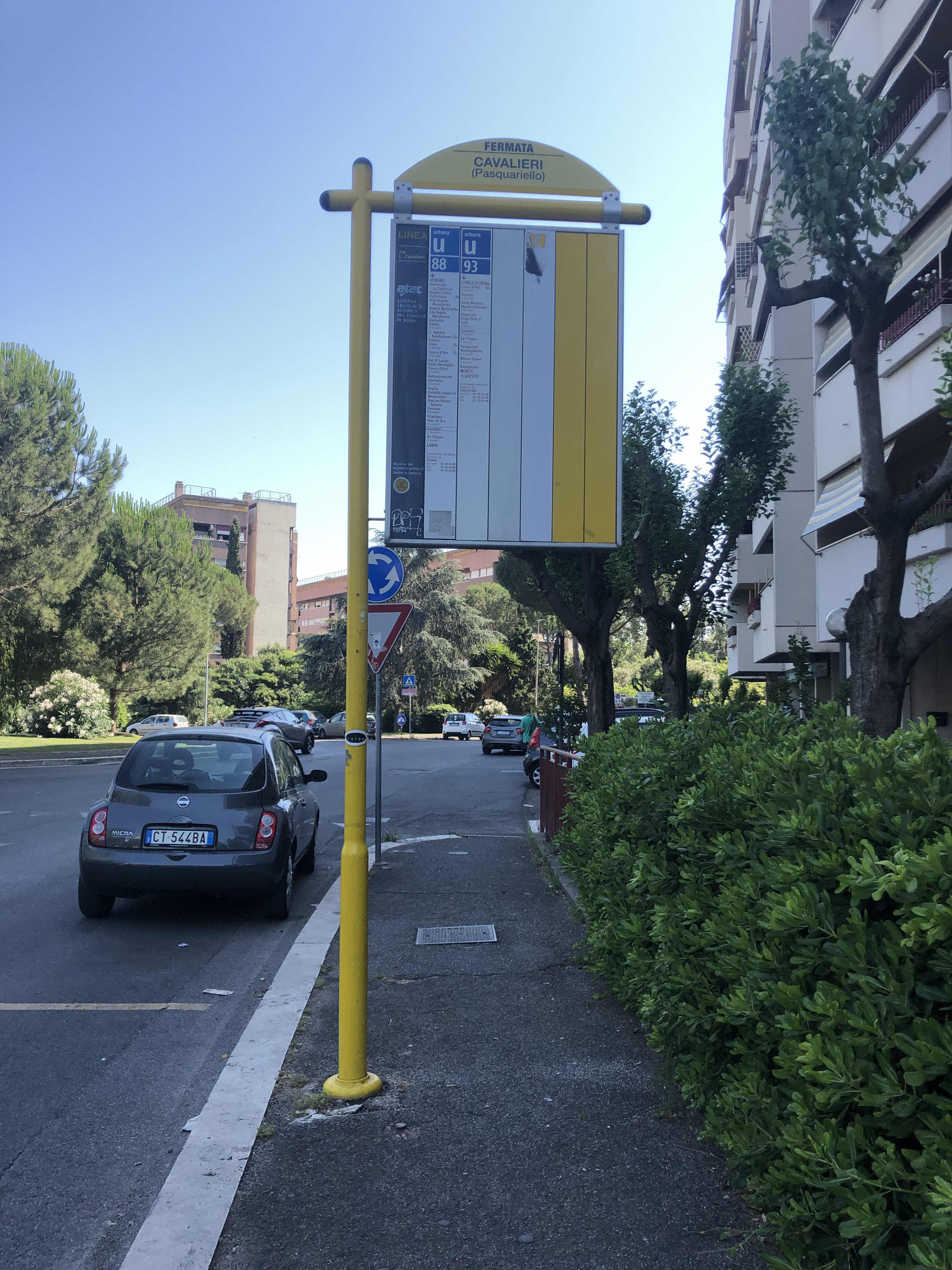 Taken by BEST04EVER
See Cavalieri/Pasquariello stop, Roma, on the map
Public transit to Cavalieri/Pasquariello stop (ID: 73794) in Roma
Looking for directions to Cavalieri/Pasquariello in Roma, Italy?
Download the Moovit App to find the current schedule and step-by-step directions for Bus, Metro or Train routes that pass through Cavalieri/Pasquariello.
Looking for the nearest stops closest to Cavalieri/Pasquariello ? Check out this list of closest stops to your destination: Cavalieri/Pasquariello; Talli/Benti Bulgarelli; Fidene; Jonio.
Bus: 88, 90, 93, C5, N90, 334, 336.Train: FL1, FL3.Metro: B.
We make riding on public transit to Cavalieri/Pasquariello easy, which is why over 1.7 billion users, including users in Roma trust Moovit as the best app for public transit.
Use the app to navigate to popular places including to the airport, hospital, stadium, grocery store, mall, coffee shop, school, college, and university.
Cavalieri/Pasquariello stop’s code is 73794
The first line to this stop is 88, at 5:23 AM, and the last line is 88 at 12:33 AM.
This stop serves ATAC’s lines
- Cavalieri/Pasquariello,
- Talli/Benti Bulgarelli
Bus stops near Cavalieri/Pasquariello stop
- Fidene
Train station near Cavalieri/Pasquariello station
- Jonio
Metro station near Cavalieri/Pasquariello station
- Sezze | Anfiteatro,
- Via Sottocampo 2,
- Newton/Colli Portuensi,
- De Filippo/Pica,
- Casilina/Berardi,
- Castelforte | Suio Thermal Baths,
- Santa Maria Delle Mole | Maroncelli St,
- Cancelliera,
- Anzio | Cincinnato Beach,
- Monte Compatri-Pantano,
- Subiaco | Sublacense Road (Km 12),
- Corso/Chigi Square,
- Riano via Giovanni XXIII (City Hall),
- Fucini/Sacchetti,
- Alberone,
- Corso Italia/Porta Pia,
- Settebagni/Maddaleno,
- Prati Fiscali/Villa Spada,
- Caravaggio Square,
- Torrice | Casilina Street Prata Street
Popular public transit stations in Roma
Get around Roma by public transit!
Traveling around Roma has never been so easy. See step by step directions as you travel to any attraction, street or major public transit station. View bus and train schedules, arrival times, service alerts and detailed routes on a map, so you know exactly how to get to anywhere in Roma.
When traveling to any destination around Roma use Moovit's Live Directions with Get Off Notifications to know exactly where and how far to walk, how long to wait for your line, and how many stops are left. Moovit will alert you when it's time to get off — no need to constantly re-check whether yours is the next stop.
Wondering how to use public transit in Roma or how to pay for public transit in Roma? Moovit public transit app can help you navigate your way with public transit easily, and at minimum cost. It includes public transit fees, ticket prices, and costs. Looking for a map of Roma public transit lines? Moovit public transit app shows all public transit maps in Roma with all Bus, Train, Metro, Light Rail, Ferry, Funicular and Gondola routes and stops on an interactive map.
Rome and Lazio has 7 transit type(s), including: Bus, Train, Metro, Light Rail, Ferry, Funicular and Gondola, operated by several transit agencies, including ATAC, Cotral, Trenitalia, Troiani Transportation Services, BIS, ATR Mobility, Tuscia, Shuttle, Seatour, Troiani Bus Lines, CSC Mobility, Terravision, ATRAL, Tambus and Sitbus