Cherry & Market SW stop - Monday schedule
| Line | Direction | Time |
|---|---|---|
| 21 | 21 Cherry to Downtown Long Beach | 4:56 AM |
| 21 | 21 Cherry to Downtown Long Beach | 5:36 AM |
| 21 | 21 Cherry to Downtown Long Beach | 6:20 AM |
| 21 | 21 Cherry to Downtown Long Beach | 6:47 AM |
| 21 | 21 Cherry to Downtown Long Beach | 7:17 AM |
| 21 | 21 Cherry to Downtown Long Beach | 7:47 AM |
| 21 | 21 Cherry to Downtown Long Beach | 8:17 AM |
| 21 | 21 Cherry to Downtown Long Beach | 8:47 AM |
| 21 | 21 Cherry to Downtown Long Beach | 9:16 AM |
| 21 | 21 Cherry to Downtown Long Beach | 9:46 AM |
| 21 | 21 Cherry to Downtown Long Beach | 10:16 AM |
| 21 | 21 Cherry to Downtown Long Beach | 10:45 AM |
| 21 | 21 Cherry to Downtown Long Beach | 11:15 AM |
| 21 | 21 Cherry to Downtown Long Beach | 11:45 AM |
| 21 | 21 Cherry to Downtown Long Beach | 12:15 PM |
| 21 | 21 Cherry to Downtown Long Beach | 12:42 PM |
| 21 | 21 Cherry to Downtown Long Beach | 1:12 PM |
| 21 | 21 Cherry to Downtown Long Beach | 1:42 PM |
| 21 | 21 Cherry to Downtown Long Beach | 2:11 PM |
| 21 | 21 Cherry to Downtown Long Beach | 2:41 PM |
| 21 | 21 Cherry to Downtown Long Beach | 3:11 PM |
| 21 | 21 Cherry to Downtown Long Beach | 3:41 PM |
| 21 | 21 Cherry to Downtown Long Beach | 4:11 PM |
| 21 | 21 Cherry to Downtown Long Beach | 4:41 PM |
| 21 | 21 Cherry to Downtown Long Beach | 5:12 PM |
Directions to Cherry & Market SW stop (Long Beach) with public transit
The following transit lines have routes that pass near Cherry & Market SW
 Bus: 191, 192, 21, 22, 111.
- Subway: A LINE.
How to get to Cherry & Market SW stop by bus?
Click on the bus route to see step by step directions with maps, line arrival times and updated time schedules.
Bus stops near Cherry & Market SW stop in Long Beach
- Cherry & Candlewood NE, 1 min walk,
- South & Cherry NW, 10 min walk,
- Paramount & Candlewood SW, 11 min walk,
- Paramount & Candlewood NE, 11 min walk,
Subway stations near Cherry & Market SW station in Long Beach
- Del Amo Station, 60 min walk,
Bus lines to Cherry & Market SW stop in Long Beach
- 21, 21 Cherry to Downtown Long Beach,
- 192, 192 Santa Fe to Downtown Long Beach,
- 22, 22 Downey Ave to Downtown Long Beach,
- 111, 111 Bdwy-Lkwd to South St via LB Airport,
- 112, 112 Bdwy-Clark to South St via LBCC,
What are the closest stations to Cherry & Market SW?
The closest stations to Cherry & Market SW are:
- Cherry & Candlewood NE stop is 72 yards away, 1 min walk.
- South & Cherry NW stop is 796 yards away, 10 min walk.
- Paramount & Candlewood SW stop is 880 yards away, 11 min walk.
- Paramount & Candlewood NE stop is 895 yards away, 11 min walk.
- Del Amo Station is 5220 yards away, 60 min walk.
Which bus lines stop near Cherry & Market SW?
These bus lines stop near Cherry & Market SW: 191, 192, 21.
What’s the nearest bus station to Cherry & Market SW in Long Beach?
The nearest bus station to Cherry & Market SW in Long Beach is Cherry & Candlewood NE. It’s a 1 min walk away.
What time is the first subway to Cherry & Market SW in Long Beach?
The A LINE is the first subway that goes to Cherry & Market SW in Long Beach. It stops nearby at 3:45 AM.
What time is the last subway to Cherry & Market SW in Long Beach?
The A LINE is the last subway that goes to Cherry & Market SW in Long Beach. It stops nearby at 1:22 AM.
What time is the first bus to Cherry & Market SW in Long Beach?
The 21 is the first bus that goes to Cherry & Market SW in Long Beach. It stops nearby at 4:55 AM.
What time is the last bus to Cherry & Market SW in Long Beach?
The 21 is the last bus that goes to Cherry & Market SW in Long Beach. It stops nearby at 12:05 AM.
Cherry & Market SW station
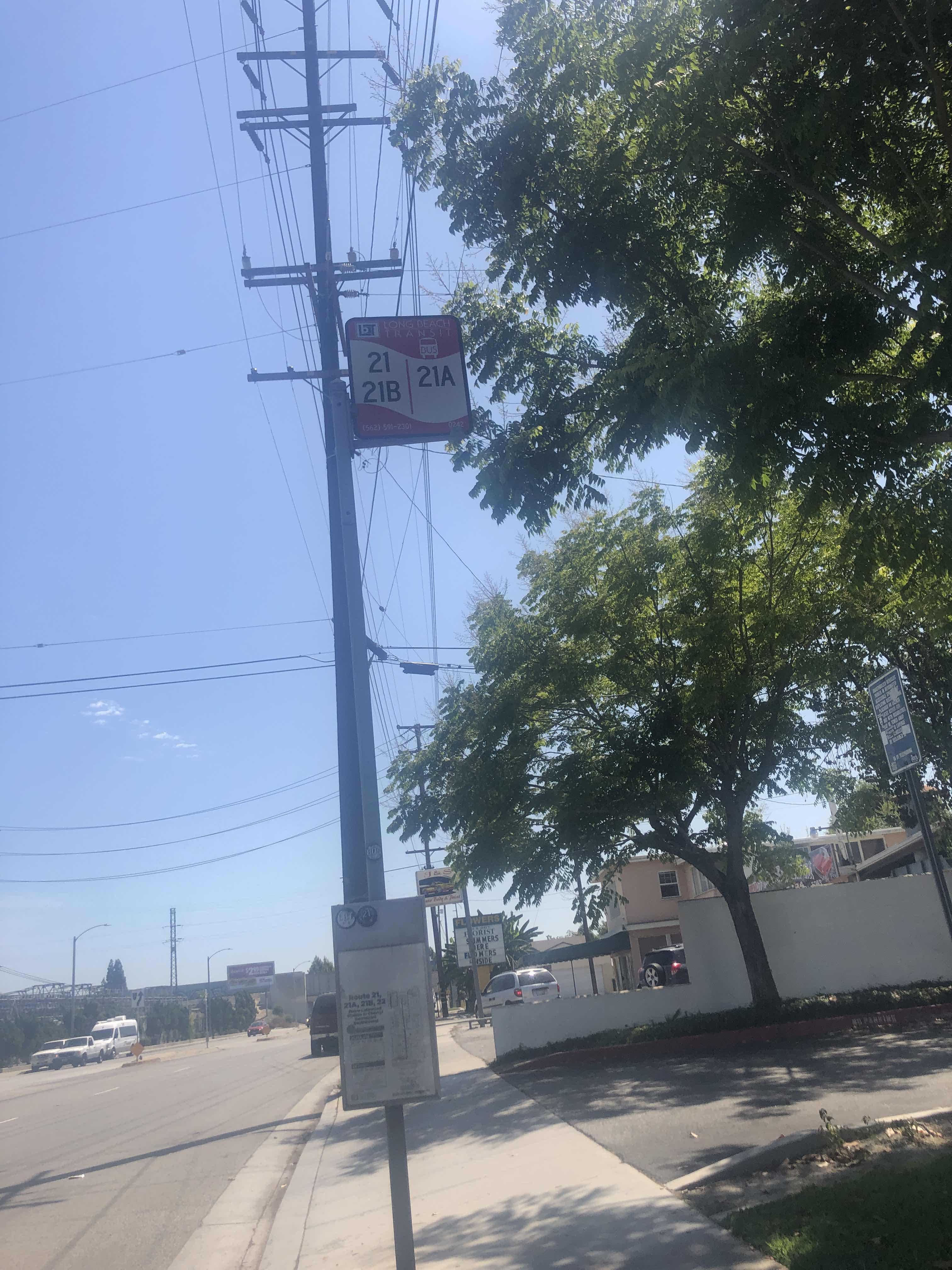 Taken by Tommy G.
See Cherry & Market SW stop, Long Beach, on the map
Public transit to Cherry & Market SW stop (ID: 0242) in Long Beach
Looking for directions to Cherry & Market SW in Long Beach, United States?
Download the Moovit App to find the current schedule and step-by-step directions for Bus routes that pass through Cherry & Market SW.
Looking for the nearest stops closest to Cherry & Market SW ? Check out this list of closest stops to your destination: Cherry & Candlewood NE; South & Cherry NW; Paramount & Candlewood SW; Paramount & Candlewood NE; Del Amo Station.
Bus: 191, 192, 21, 22, 111, 112.Subway: A LINE.
We make riding on public transit to Cherry & Market SW easy, which is why over 1.7 billion users, including users in Long Beach trust Moovit as the best app for public transit.
Use the app to navigate to popular places including to the airport, hospital, stadium, grocery store, mall, coffee shop, school, college, and university.
Cherry & Market SW stop’s code is 0242
The first line to this stop is 21, at 4:56 AM, and the last line is 21 at 10:52 PM.
5367 Cherry Ave, Long Beach, CA, USA
This stop serves Long Beach Transit’s lines
- Cherry & Candlewood NE,
- South & Cherry NW,
- Paramount & Candlewood SW,
- Paramount & Candlewood NE
Bus stops near Cherry & Market SW stop
- Del Amo Station
Subway station near Cherry & Market SW station
- Colorado / Orange Grove,
- Riverside / Woodman,
- Hawthorne / 118th,
- Ocean & Magnolia NW,
- Vermont Ave & Franklin Ave,
- Century / Prairie,
- North Hollywood Station,
- Telegraph / Orr and Day,
- Las Virgenes Rd & 101 Fwy (Eastbound),
- P.C.H. & Eubank Ave.,
- Division 7 Layover,
- MLK Jr. & Normandie Ave.,
- Arcadia Station (A Line),
- Normandie / Slauson,
- Rosemead / Arcadia,
- Pacific / Florence,
- San Gabriel / California,
- Goleta Amtrak,
- Santa Monica / Camden,
- Golden Lantern-Dana Point Harbor
Popular public transit stations in Long Beach
Get around Long Beach by public transit!
Traveling around Long Beach has never been so easy. See step by step directions as you travel to any attraction, street or major public transit station. View bus and train schedules, arrival times, service alerts and detailed routes on a map, so you know exactly how to get to anywhere in Long Beach.
When traveling to any destination around Long Beach use Moovit's Live Directions with Get Off Notifications to know exactly where and how far to walk, how long to wait for your line, and how many stops are left. Moovit will alert you when it's time to get off — no need to constantly re-check whether yours is the next stop.
Wondering how to use public transit in Long Beach or how to pay for public transit in Long Beach? Moovit public transit app can help you navigate your way with public transit easily, and at minimum cost. It includes public transit fees, ticket prices, and costs. Looking for a map of Long Beach public transit lines? Moovit public transit app shows all public transit maps in Long Beach with all Bus, Train, Subway, Ferry and Funicular routes and stops on an interactive map.
Los Angeles has 5 transit type(s), including: Bus, Train, Subway, Ferry and Funicular, operated by several transit agencies, including Metro, Metro Event Service, Alhambra Community Transit (ACT), Arcadia Transit, Artesia Transit, AVTA, Baldwin Park Transit, Beach Cities Transit, Beaumont Transit, Bell Gardens Town Trolley, Bellflower Bus, Big Blue Bus, Burbank Bus, Calabasas Trolley and Camarillo Area Transit