Dobbin Center stop - Sunday schedule
| Line | Direction | Time |
|---|---|---|
| 501 | Arundel Mills | 9:11 AM |
| 408 | Mall In Columbia | 9:22 AM |
| 408 | Waterloo Park | 9:26 AM |
| 501 | Mall In Columbia | 9:27 AM |
| 501 | Arundel Mills | 10:11 AM |
| 408 | Mall In Columbia | 10:22 AM |
| 501 | Mall In Columbia | 10:27 AM |
| 501 | Arundel Mills | 11:11 AM |
| 408 | Mall In Columbia | 11:22 AM |
| 408 | Waterloo Park | 11:26 AM |
| 501 | Mall In Columbia | 11:27 AM |
| 501 | Arundel Mills | 12:11 PM |
| 408 | Mall In Columbia | 12:22 PM |
| 501 | Mall In Columbia | 12:27 PM |
| 501 | Arundel Mills | 1:11 PM |
| 408 | Mall In Columbia | 1:22 PM |
| 408 | Waterloo Park | 1:26 PM |
| 501 | Mall In Columbia | 1:27 PM |
| 501 | Arundel Mills | 2:11 PM |
| 408 | Mall In Columbia | 2:22 PM |
| 501 | Mall In Columbia | 2:27 PM |
| 501 | Arundel Mills | 3:11 PM |
| 408 | Mall In Columbia | 3:22 PM |
| 408 | Waterloo Park | 3:26 PM |
| 501 | Mall In Columbia | 3:27 PM |
Directions to Dobbin Center stop (Howard County) with public transit
The following transit lines have routes that pass near Dobbin Center
 Bus: 501, 320, 345, 408, 203.
How to get to Dobbin Center stop by bus?
Click on the bus route to see step by step directions with maps, line arrival times and updated time schedules.
Bus stops near Dobbin Center stop in Howard County
- Dobbin Rd & Dobbin Ctr Opp Nb, 6 min walk,
- Old Dobbin Rd & Md 175 FS Nb, 10 min walk,
- Columbia Crossing Cir West (Northbound), 16 min walk,
- Snowden River Park & Ride, 23 min walk,
Bus lines to Dobbin Center stop in Howard County
- 320, 320/7 Johns Hopkins,
- 345, 345/9 Clarksville Park & Ride,
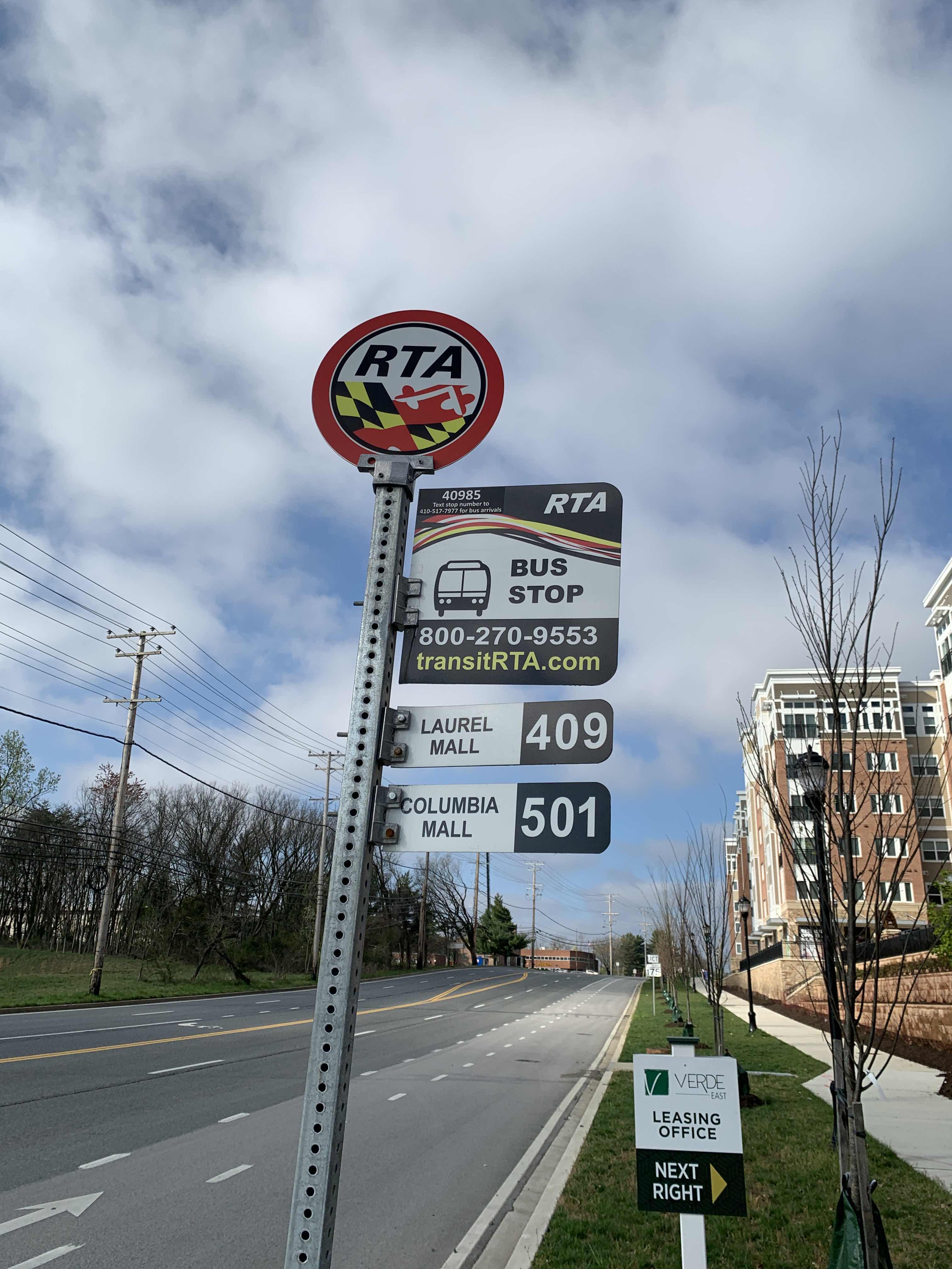
- 408, Mall In Columbia,
- 203, 203/2 Rockville,
- 310, 310/7 Columbia Mall,
- 501, Mall In Columbia,
What are the closest stations to Dobbin Center?
The closest stations to Dobbin Center are:
- Dobbin Rd & Dobbin Ctr Opp Nb stop is 454 yards away, 6 min walk.
- Old Dobbin Rd & Md 175 FS Nb stop is 840 yards away, 10 min walk.
- Columbia Crossing Cir West (Northbound) stop is 1391 yards away, 16 min walk.
- Snowden River Park & Ride stop is 1972 yards away, 23 min walk.
Which bus line stops near Dobbin Center?
501 (Mall In Columbia)
What’s the nearest bus station to Dobbin Center in Howard County?
The nearest bus station to Dobbin Center in Howard County is Dobbin Rd & Dobbin Ctr Opp Nb. It’s a 6 min walk away.
What time is the first bus to Dobbin Center in Howard County?
The 345 is the first bus that goes to Dobbin Center in Howard County. It stops nearby at 5:18 AM.
What time is the last bus to Dobbin Center in Howard County?
The 408 is the last bus that goes to Dobbin Center in Howard County. It stops nearby at 10:34 PM.
Dobbin Center station
 Taken by Anonymous
See Dobbin Center stop, Howard County, on the map
Public transit to Dobbin Center stop (ID: 40891) in Howard County
Looking for directions to Dobbin Center in Howard County, United States?
Download the Moovit App to find the current schedule and step-by-step directions for Bus or Train routes that pass through Dobbin Center.
Looking for the nearest stops closest to Dobbin Center ? Check out this list of closest stops to your destination: Dobbin Rd & Dobbin Ctr Opp Nb; Old Dobbin Rd & Md 175 FS Nb; Columbia Crossing Cir West (Northbound); Snowden River Park & Ride.
Bus: 501, 320, 345, 408, 203, 310.
We make riding on public transit to Dobbin Center easy, which is why over 1.7 billion users, including users in Howard County trust Moovit as the best app for public transit.
Get to Dobbin Center with public transit and pay for the ride in the Moovit app. In addition to all info you may need for your trip to Dobbin Center, including live directions, real-time arrivals and fare prices, you can also buy public transit passes for your rides. No need for cash or paper tickets to get to Dobbin Center - everything you need is accessible in the app with a click of the button.
Use the app to navigate to popular places including to the airport, hospital, stadium, grocery store, mall, coffee shop, school, college, and university.
Dobbin Center stop’s code is 40891
The first line to this stop is 501, at 9:11 AM, and the last line is 501 at 7:27 PM.
This stop serves RTA of Central Maryland’s lines
Popular routes from Dobbin Center stop, Howard County
- Dobbin Rd & Dobbin Ctr Opp Nb,
- Old Dobbin Rd & Md 175 FS Nb,
- Columbia Crossing Cir West (Northbound),
- Snowden River Park & Ride
Bus stops near Dobbin Center stop
- Walmart at Russett Green East - Laurel,
- P St Nw+15 St NW,
- Stadium-Armory,
- Edgewood St Ne+7 St NE,
- Route 355/South Market Street at Noland,
- Wayne Ave & @313,
- Baltimore St & Frederick St,
- 16 St Nw+Colorado Av NW,
- Baltimore Avenue And Powder Mill Road (Southbound),
- Old Georgetown Rd & Cordell Ave,
- 16 St Nw+Oak St NW,
- 3210 Kinross Cir,
- Homecrest Rd & Homecrest House,
- Rhode Island Ave & 37th St,
- Southern Av Se+S Capitol St SW,
- Greenbelt Rd & Nasa Goddard Main Gate,
- Minstrel Way / Snowden River Pkwy (Southbound),
- Greenbelt Rd+57 Av,
- Monument Dr @ Monument Hill Way,
- Old Georgetown Rd & Tuckerman Ln
Popular public transit stations in Howard County
Get around Howard County by public transit!
Traveling around Howard County has never been so easy. See step by step directions as you travel to any attraction, street or major public transit station. View bus and train schedules, arrival times, service alerts and detailed routes on a map, so you know exactly how to get to anywhere in Howard County.
When traveling to any destination around Howard County use Moovit's Live Directions with Get Off Notifications to know exactly where and how far to walk, how long to wait for your line, and how many stops are left. Moovit will alert you when it's time to get off — no need to constantly re-check whether yours is the next stop.
Wondering how to use public transit in Howard County or how to pay for public transit in Howard County? Moovit public transit app can help you navigate your way with public transit easily, and at minimum cost. It includes public transit fees, ticket prices, and costs. Looking for a map of Howard County public transit lines? Moovit public transit app shows all public transit maps in Howard County with all Bus, Train, Metro, Light Rail and Ferry routes and stops on an interactive map.
Washington, D.C. - Baltimore, MD has 5 transit type(s), including: Bus, Train, Metro, Light Rail and Ferry, operated by several transit agencies, including WMATA, Montgomery County Ride On, Fairfax Connector, Prince Georges County's TheBus, PRTC, DASH - Alexandria, Arlington Transit (ART), RTA of Central Maryland, MDOT MTA, MDOT MTA Light RailLink, MDOT MTA Commuter Bus, MDOT MTA Local Bus, FXBGO!, Virginia Railway Express (VRE) and MARC