How to get to Domsei by bus?
Click on the bus route to see step by step directions with maps, line arrival times and updated time schedules.
From Klinikum am Gesundbrunnen, Heilbronn
86 minFrom Slk-Kliniken Heilbronn P1, Heilbronn
85 minFrom POCO Einrichtungsmärkte, Böckingen
95 minFrom Stadtgalerie / Galeria Kaufhof, Heilbronn
73 minFrom Modepark Röther, Heilbronn
64 minFrom Eroscenter Heilbronn, Heilbronn
54 minFrom H7, Heilbronn
54 minFrom Pflanzen-Kölle, Heilbronn
89 minFrom FlixBus Haltestelle, Heilbronn
48 minFrom Theresienwiese, Heilbronn
53 min
How to get to Domsei by train?
Click on the train route to see step by step directions with maps, line arrival times and updated time schedules.
Bus stops near Domsei in Verwaltungsgemeinschaft Bad Friedrichshall
Train stations near Domsei in Verwaltungsgemeinschaft Bad Friedrichshall
Bus lines to Domsei in Verwaltungsgemeinschaft Bad Friedrichshall
- SEV S41/S42, Neckarsulm,VIEW
- 602, Untergriesheim, Schule,VIEW
- 604, Gundelsheim (Neckar),VIEW
- 615, Bad Friedrichshall Hbf,VIEW
- 691, Kochendorf, Bergstraße,VIEW
- 625, Neuenstadt (K) ZOB Lindenplatz Bstg 6 - Bad Friedrichshall Hbf,VIEW
- 628, Bad Friedrichshall Hbf - Bad Friedrichshall Hbf,VIEW
- MEX 12, Bietigheim Gleis 10 - Heilbronn Hauptbahnhof Gleis 4,VIEW
- MEX 18, Tübingen Hauptbahnhof - Osterburken, Bahnhof,VIEW
- 602R, Bad Friedrichshall-Kochendorf - Bad Friedrichshall-Kochendorf,VIEW
- RE 8, Würzburg Hbf - Stuttgart Hauptbahnhof (oben) Gleis 7,VIEW
- RE 10A, Mannheim, Hauptbahnhof - Heilbronn Hauptbahnhof Gleis 5,VIEW
- RE 10B, Mannheim, Hauptbahnhof - Heilbronn Hauptbahnhof Gleis 5,VIEW
- S41, Heilbronn Hbf/Willy-Brandt-Pl. - Mosbach, Bahnhof,VIEW
- S42, Sinsheim, Hauptbahnhof - Heilbronn Hbf/Willy-Brandt-Pl.,VIEW
- 694, Heilbronn Hbf/Busbahnhof,VIEW
- BÜRGERBUS 1, Bad Wimpfen, Im Tal,VIEW
What are the closest stations to Domsei?
The closest stations to Domsei are:
- Bad Friedrichshall Hbf is 68 meters away, 1 min walk.
- Jagstfeld, Offenauer Straße is 170 meters away, 3 min walk.
- Jagstfeld, Deutschordenstraße is 562 meters away, 8 min walk.
- Bad Wimpfen, Im Tal is 1417 meters away, 19 min walk.
- Bad Wimpfen Im Tal is 1419 meters away, 19 min walk.
Which train lines stop near Domsei?
These train lines stop near Domsei: MEX18, RE10B, S41, S42.
Which bus lines stop near Domsei?
These bus lines stop near Domsei: 602, 691, 694.
What’s the nearest train station to Domsei in Verwaltungsgemeinschaft Bad Friedrichshall?
The nearest train stations to Domsei in Verwaltungsgemeinschaft Bad Friedrichshall are Bad Wimpfen, Im Tal and Bad Wimpfen Im Tal. The closest one is a 19 min walk away.
What’s the nearest bus station to Domsei in Verwaltungsgemeinschaft Bad Friedrichshall?
The nearest bus station to Domsei in Verwaltungsgemeinschaft Bad Friedrichshall is Bad Friedrichshall Hbf. It’s a 1 min walk away.
What time is the first light rail to Domsei in Verwaltungsgemeinschaft Bad Friedrichshall?
The S42 is the first light rail that goes to Domsei in Verwaltungsgemeinschaft Bad Friedrichshall. It stops nearby at 4:58 AM.
What time is the last light rail to Domsei in Verwaltungsgemeinschaft Bad Friedrichshall?
The S41 is the last light rail that goes to Domsei in Verwaltungsgemeinschaft Bad Friedrichshall. It stops nearby at 12:48 AM.
What time is the first train to Domsei in Verwaltungsgemeinschaft Bad Friedrichshall?
The S42 is the first train that goes to Domsei in Verwaltungsgemeinschaft Bad Friedrichshall. It stops nearby at 4:58 AM.
What time is the last train to Domsei in Verwaltungsgemeinschaft Bad Friedrichshall?
The RE 10A is the last train that goes to Domsei in Verwaltungsgemeinschaft Bad Friedrichshall. It stops nearby at 1:16 AM.
What time is the first bus to Domsei in Verwaltungsgemeinschaft Bad Friedrichshall?
The 691 is the first bus that goes to Domsei in Verwaltungsgemeinschaft Bad Friedrichshall. It stops nearby at 5:00 AM.
What time is the last bus to Domsei in Verwaltungsgemeinschaft Bad Friedrichshall?
The 691 is the last bus that goes to Domsei in Verwaltungsgemeinschaft Bad Friedrichshall. It stops nearby at 11:53 PM.
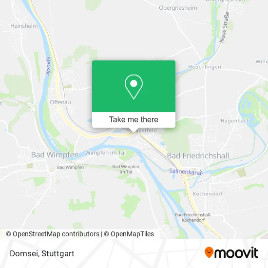
See Domsei, Verwaltungsgemeinschaft Bad Friedrichshall, on the map
Public Transit to Domsei in Verwaltungsgemeinschaft Bad Friedrichshall
Wondering how to get to Domsei in Verwaltungsgemeinschaft Bad Friedrichshall? Moovit helps you find the best way to get to Domsei with step-by-step directions from the nearest public transit station.
Moovit provides free maps and live directions to help you navigate through your city. View schedules, routes, timetables, and find out how long does it take to get to Domsei in real time.
Looking for the nearest stop or station to Domsei? Check out this list of stops closest to your destination: Bad Friedrichshall Hbf; Jagstfeld; Jagstfeld; Bad Wimpfen; Bad Wimpfen Im Tal.
Train: MEX18, RE10B, S41, S42, RB8, RB10A, RE10A, MEX12.Bus: 602, 691, 694, SEV S41/S42, 604.
Want to see if there’s another route that gets you there at an earlier time? Moovit helps you find alternative routes or times. Get directions from and directions to Domsei easily from the Moovit App or Website.
We make riding to Domsei easy, which is why over 1.5 million users, including users in Verwaltungsgemeinschaft Bad Friedrichshall, trust Moovit as the best app for public transit. You don’t need to download an individual bus app or train app, Moovit is your all-in-one transit app that helps you find the best bus time or train time available.
For information on prices of bus and train, costs and ride fares to Domsei, please check the Moovit app.
Use the app to navigate to popular places including to the airport, hospital, stadium, grocery store, mall, coffee shop, school, college, and university.
Domsei Address: Friedhofstraße 22 Jagstfeld, 74177 Bad Friedrichshall street in Verwaltungsgemeinschaft Bad Friedrichshall
- Spieler Buchbinderei Nobert,
- Medo-Med Maßageschule,
- Gaststätte Glückauf,
- Friedhof Jagstfeld,
- Friedhof Bad Friedrichshall-Jagstfeld,
- Tamildolmetscher,
- Dr. med. Wolfgang Wiese,
- Harald Kuriger Vermietungen,
- Deutschorden-Apotheke,
- Blumen Funk,
- Hans Ingo Hemmerle,
- Allianz-Generalvertretung Thomas Köhler,
- Hgv Bad Friedrichshall,
- Bf Media,
- Textilpflege Ludwig,
- Ursula Lang Heilpraktikerin,
- Emefka.Bewegtbildmanufaktur,
- Heckmann,
- Grabhuegelfeld am Sportplatz,
- Kolb . Biegert-Bauleitung und Planung Ingenieure und Landschaftsarchitektur mit Beschränkter Berufs
Places Near Domsei (Verwaltungsgemeinschaft Bad Friedrichshall)
- Hanns-Martin-Schleyer-Halle (Stuttgart Hans-Martin-Schleyerhalle), Bad Cannstatt,
- Porsche Museum, Zuffenhausen,
- Mettingen Eros-Center Puff Laufhaus, Esslingen Am Neckar,
- Hanns-Martin-Schleyer-Halle, Bad Cannstatt,
- Schleyerhalle, Bad Cannstatt,
- Mercedes-Benz Museum (Mercedes Museum Stuttgart), Bad Cannstatt,
- Porsche-Arena, Bad Cannstatt,
- Marmorsaal Im Weissenburgpark, Stuttgart-Süd,
- Wilhelma (U-Bahn Wilhelma), Bad Cannstatt,
- Mercedes-Benz Museum, Bad Cannstatt,
- Im Wizemann (Halle), Bad Cannstatt,
- SI-Centrum, Möhringen,
- Pariser Platz Stuttgart, Stuttgart-Mitte,
- Waldfriedhof, Degerloch,
- FlixBus Haltestelle, Stuttgart,
- Hauptbahnhof Stuttgart, Stuttgart-Mitte,
- Geilhaus Haus 33a, Reutlingen-Betzingen,
- Gleis 101/102 (tief), Stuttgart-Mitte,
- Klinikum Stuttgart - Katharinenhospital, Stuttgart-Mitte,
- Gasometer Pforzheim, Pforzheim
How to get to popular places in Stuttgart with public transit
Get around Verwaltungsgemeinschaft Bad Friedrichshall by public transit!
Traveling around Verwaltungsgemeinschaft Bad Friedrichshall has never been so easy. See step by step directions as you travel to any attraction, street or major public transit station. View bus and train schedules, arrival times, service alerts and detailed routes on a map, so you know exactly how to get to anywhere in Verwaltungsgemeinschaft Bad Friedrichshall.
When traveling to any destination around Verwaltungsgemeinschaft Bad Friedrichshall use Moovit's Live Directions with Get Off Notifications to know exactly where and how far to walk, how long to wait for your line, and how many stops are left. Moovit will alert you when it's time to get off — no need to constantly re-check whether yours is the next stop.
Wondering how to use public transit in Verwaltungsgemeinschaft Bad Friedrichshall or how to pay for public transit in Verwaltungsgemeinschaft Bad Friedrichshall? Moovit public transit app can help you navigate your way with public transit easily, and at minimum cost. It includes public transit fees, ticket prices, and costs. Looking for a map of Verwaltungsgemeinschaft Bad Friedrichshall public transit lines? Moovit public transit app shows all public transit maps in Verwaltungsgemeinschaft Bad Friedrichshall with all Bus, Train, Subway, Light Rail, Ferry, S-Bahn and Funicular routes and stops on an interactive map.
Stuttgart has 7 transit type(s), including: Bus, Train, Subway, Light Rail, Ferry, S-Bahn and Funicular, operated by several transit agencies, including SSB - Stadtbahn, SSB, SSB - Seilbahn / Zacke, S-Bahn Stuttgart, Rhein-Neckar-Verkehr GmbH (rnv), Karlsruher Verkehrsverbund, DB AG, DB Regiobus BW, Arverio Baden-Württemberg GmbH, DB RegioNetz Verkehrs GmbH Westfrankenbahn, DB Regio AG Baden-Württemberg, Südwestdeutsche Verkehrs-AG, DB Regio AG Mitte Region Hessen, DB and Bodensee-Oberschwaben-Bahn