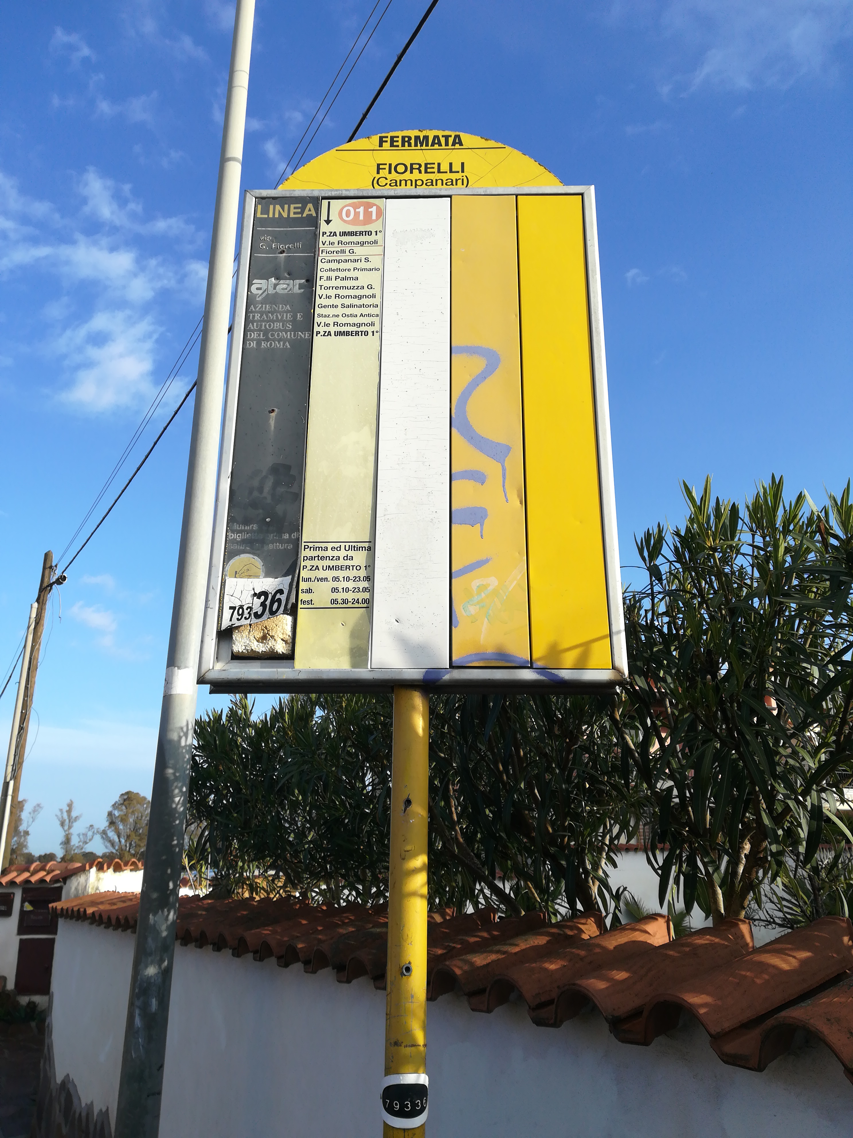
Fiorelli/Campanari stop - Monday schedule
| Line | Direction | Time |
|---|---|---|
| 011 | Romagnoli/Ostia Antica Excavations | 5:26 AM |
| 011 | Romagnoli/Ostia Antica Excavations | 5:51 AM |
| 011 | Romagnoli/Ostia Antica Excavations | 6:16 AM |
| 011 | Romagnoli/Ostia Antica Excavations | 6:41 AM |
| 011 | Romagnoli/Ostia Antica Excavations | 7:06 AM |
| 011 | Romagnoli/Ostia Antica Excavations | 7:31 AM |
| 011 | Romagnoli/Ostia Antica Excavations | 7:56 AM |
| 011 | Romagnoli/Ostia Antica Excavations | 8:21 AM |
| 011 | Romagnoli/Ostia Antica Excavations | 8:46 AM |
| 011 | Romagnoli/Ostia Antica Excavations | 9:11 AM |
| 011 | Romagnoli/Ostia Antica Excavations | 9:36 AM |
| 011 | Romagnoli/Ostia Antica Excavations | 10:01 AM |
| 011 | Romagnoli/Ostia Antica Excavations | 10:26 AM |
| 011 | Romagnoli/Ostia Antica Excavations | 10:51 AM |
| 011 | Romagnoli/Ostia Antica Excavations | 11:16 AM |
| 011 | Romagnoli/Ostia Antica Excavations | 11:41 AM |
| 011 | Romagnoli/Ostia Antica Excavations | 12:06 PM |
| 011 | Romagnoli/Ostia Antica Excavations | 12:31 PM |
| 011 | Romagnoli/Ostia Antica Excavations | 12:56 PM |
| 011 | Romagnoli/Ostia Antica Excavations | 1:21 PM |
| 011 | Romagnoli/Ostia Antica Excavations | 1:46 PM |
| 011 | Romagnoli/Ostia Antica Excavations | 2:11 PM |
| 011 | Romagnoli/Ostia Antica Excavations | 2:36 PM |
| 011 | Romagnoli/Ostia Antica Excavations | 3:01 PM |
| 011 | Romagnoli/Ostia Antica Excavations | 3:26 PM |
Directions to Fiorelli/Campanari stop (Roma) with public transit
The following transit lines have routes that pass near Fiorelli/Campanari
 Bus: 011, 04, 712.
- Train: FC2.
How to get to Fiorelli/Campanari stop by bus?
Click on the bus route to see step by step directions with maps, line arrival times and updated time schedules.
How to get to Fiorelli/Campanari stop by train?
Click on the train route to see step by step directions with maps, line arrival times and updated time schedules.
Bus stops near Fiorelli/Campanari stop in Roma
- Fiorelli/Scaglia, 4 min walk,
Train stations near Fiorelli/Campanari station in Roma
- South Acilia-Dragona, 34 min walk,
Bus lines to Fiorelli/Campanari stop in Roma
- 011, Romagnoli/Ostia Antica Excavations,
What are the closest stations to Fiorelli/Campanari?
The closest stations to Fiorelli/Campanari are:
- Fiorelli/Scaglia stop is 284 meters away, 4 min walk.
- South Acilia-Dragona station is 2691 meters away, 34 min walk.
Which bus lines stop near Fiorelli/Campanari?
These bus lines stop near Fiorelli/Campanari: 011, 04, 712.
Which train line stops near Fiorelli/Campanari?
FC2 (Cristoforo Colombo)
What’s the nearest bus station to Fiorelli/Campanari in Roma?
The nearest bus station to Fiorelli/Campanari in Roma is Fiorelli/Scaglia. It’s a 4 min walk away.
What time is the first train to Fiorelli/Campanari in Roma?
The FC2 is the first train that goes to Fiorelli/Campanari in Roma. It stops nearby at 5:26 AM.
What time is the last train to Fiorelli/Campanari in Roma?
The FC2 is the last train that goes to Fiorelli/Campanari in Roma. It stops nearby at 9:26 PM.
What time is the first bus to Fiorelli/Campanari in Roma?
The 011 is the first bus that goes to Fiorelli/Campanari in Roma. It stops nearby at 5:24 AM.
What time is the last bus to Fiorelli/Campanari in Roma?
The 011 is the last bus that goes to Fiorelli/Campanari in Roma. It stops nearby at 12:25 AM.
Fiorelli/Campanari station
 Taken by Anonymous
See Fiorelli/Campanari stop, Roma, on the map
Public transit to Fiorelli/Campanari stop (ID: 79336) in Roma
Looking for directions to Fiorelli/Campanari in Roma, Italy?
Download the Moovit App to find the current schedule and step-by-step directions for Bus or Train routes that pass through Fiorelli/Campanari.
Looking for the nearest stops closest to Fiorelli/Campanari ? Check out this list of closest stops to your destination: Fiorelli/Scaglia; South Acilia-Dragona.
Bus: 011, 04, 712.Train: FC2.
We make riding on public transit to Fiorelli/Campanari easy, which is why over 1.7 billion users, including users in Roma trust Moovit as the best app for public transit.
Use the app to navigate to popular places including to the airport, hospital, stadium, grocery store, mall, coffee shop, school, college, and university.
Fiorelli/Campanari stop’s code is 79336
The first line to this stop is 011, at 5:26 AM, and the last line is 011 at 12:23 AM.
This stop serves BIS’s lines
- Fiorelli/Scaglia
Bus stop near Fiorelli/Campanari stop
- South Acilia-Dragona
Train station near Fiorelli/Campanari station
- Frosinone,
- Rome | Prenestina Street Rocca Cencia Street,
- Ardea | Laurentina Street Pontina Vecchia Street,
- XXII Street,
- Lanuvio | Via Nettunense (Bellavista),
- Aprilia,
- Nomentana/St. Agnes,
- Collegiove | Depot,
- Arcinazzo | Highlands,
- Bravetta/Pisana,
- Garibaldi/Fabrizi,
- Rosa Raimondi/Lazio Region,
- Saturnia,
- Borghetto | Railway Station,
- Trieste/Gorizia,
- Jonio/Talenti,
- Togliatti/Bardanzellu,
- Pincherle/Parravano,
- Fiumicino | Aurelia Road (Torrimpietra),
- Gardenie
Popular public transit stations in Roma
Get around Roma by public transit!
Traveling around Roma has never been so easy. See step by step directions as you travel to any attraction, street or major public transit station. View bus and train schedules, arrival times, service alerts and detailed routes on a map, so you know exactly how to get to anywhere in Roma.
When traveling to any destination around Roma use Moovit's Live Directions with Get Off Notifications to know exactly where and how far to walk, how long to wait for your line, and how many stops are left. Moovit will alert you when it's time to get off — no need to constantly re-check whether yours is the next stop.
Wondering how to use public transit in Roma or how to pay for public transit in Roma? Moovit public transit app can help you navigate your way with public transit easily, and at minimum cost. It includes public transit fees, ticket prices, and costs. Looking for a map of Roma public transit lines? Moovit public transit app shows all public transit maps in Roma with all Bus, Train, Metro, Light Rail, Ferry, Funicular and Gondola routes and stops on an interactive map.
Rome and Lazio has 7 transit type(s), including: Bus, Train, Metro, Light Rail, Ferry, Funicular and Gondola, operated by several transit agencies, including ATAC, Cotral, Trenitalia, Troiani Transportation Services, BIS, ATR Mobility, Tuscia, Shuttle, Seatour, Troiani Bus Lines, CSC Mobility, Terravision, ATRAL, Tambus and Sitbus