Five Points at Chestnut St stop - Saturday schedule
| Line | Direction | Time |
|---|---|---|
| 94 | 94l Linden | 7:04 AM |
| 94 | 94l Linden | 7:19 AM |
| 94 | 94l Linden | 7:49 AM |
| 94 | 94l Linden | 8:18 AM |
| 94 | 94l Linden | 8:30 AM |
| 94 | 94l Linden | 9:23 AM |
| 113 | 113s Dunellen Salem Road | 9:42 AM |
| 94 | 94l Linden | 10:05 AM |
| 94 | 94l Linden | 10:29 AM |
| 94 | 94l Linden | 10:53 AM |
| 113 | 113s Dunellen Salem Road | 11:22 AM |
| 94 | 94l Linden | 11:29 AM |
| 94 | 94l Linden | 12:05 PM |
| 94 | 94l Linden | 12:29 PM |
| 94 | 94l Linden | 12:53 PM |
| 113 | 113s Dunellen Salem Road | 1:02 PM |
| 94 | 94l Linden | 1:29 PM |
| 94 | 94l Linden | 2:05 PM |
| 94 | 94l Linden | 2:29 PM |
| 113 | 113s Dunellen Salem Road | 2:42 PM |
| 94 | 94l Linden | 3:05 PM |
| 94 | 94l Linden | 3:42 PM |
| 113 | 113s Dunellen Salem Road | 4:19 PM |
| 94 | 94l Linden | 4:19 PM |
| 94 | 94l Linden | 4:43 PM |
Directions to Five Points at Chestnut St stop (New York - New Jersey) with public transit
The following transit lines have routes that pass near Five Points at Chestnut St
 Bus: 113, 94.
- Train: RVL, NC, NJCL.
How to get to Five Points at Chestnut St stop by bus?
Click on the bus route to see step by step directions with maps, line arrival times and updated time schedules.
How to get to Five Points at Chestnut St stop by train?
Click on the train route to see step by step directions with maps, line arrival times and updated time schedules.
Bus stops near Five Points at Chestnut St stop in New York - New Jersey
- Five Points at Chestnut St, 1 min walk,
Train stations near Five Points at Chestnut St station in New York - New Jersey
- Elizabeth, 2 min walk,
- Cranford, 31 min walk,
Bus lines to Five Points at Chestnut St stop in New York - New Jersey
- 94, 94l Linden,
- 113, 113s Dunellen Salem Road,
What are the closest stations to Five Points at Chestnut St?
The closest stations to Five Points at Chestnut St are:
- Five Points at Chestnut St is 17 yards away, 1 min walk.
- Elizabeth is 128 yards away, 2 min walk.
- Cranford is 2635 yards away, 31 min walk.
Which bus lines stop near Five Points at Chestnut St?
These bus lines stop near Five Points at Chestnut St: 113, 94.
Which train line stops near Five Points at Chestnut St?
RVL (Hoboken / NY Penn Station)
What’s the nearest train station to Five Points at Chestnut St in New York - New Jersey?
The nearest train station to Five Points at Chestnut St in New York - New Jersey is Elizabeth. It’s a 2 min walk away.
What’s the nearest bus station to Five Points at Chestnut St in New York - New Jersey?
The nearest bus station to Five Points at Chestnut St in New York - New Jersey is Five Points at Chestnut St. It’s a 1 min walk away.
What time is the first train to Five Points at Chestnut St in New York - New Jersey?
The NC is the first train that goes to Five Points at Chestnut St in New York - New Jersey. It stops nearby at 4:43 AM.
What time is the last train to Five Points at Chestnut St in New York - New Jersey?
The NC is the last train that goes to Five Points at Chestnut St in New York - New Jersey. It stops nearby at 1:52 AM.
What time is the first bus to Five Points at Chestnut St in New York - New Jersey?
The 94 is the first bus that goes to Five Points at Chestnut St in New York - New Jersey. It stops nearby at 5:38 AM.
What time is the last bus to Five Points at Chestnut St in New York - New Jersey?
The 113 is the last bus that goes to Five Points at Chestnut St in New York - New Jersey. It stops nearby at 12:46 AM.
Five Points at Chestnut St station
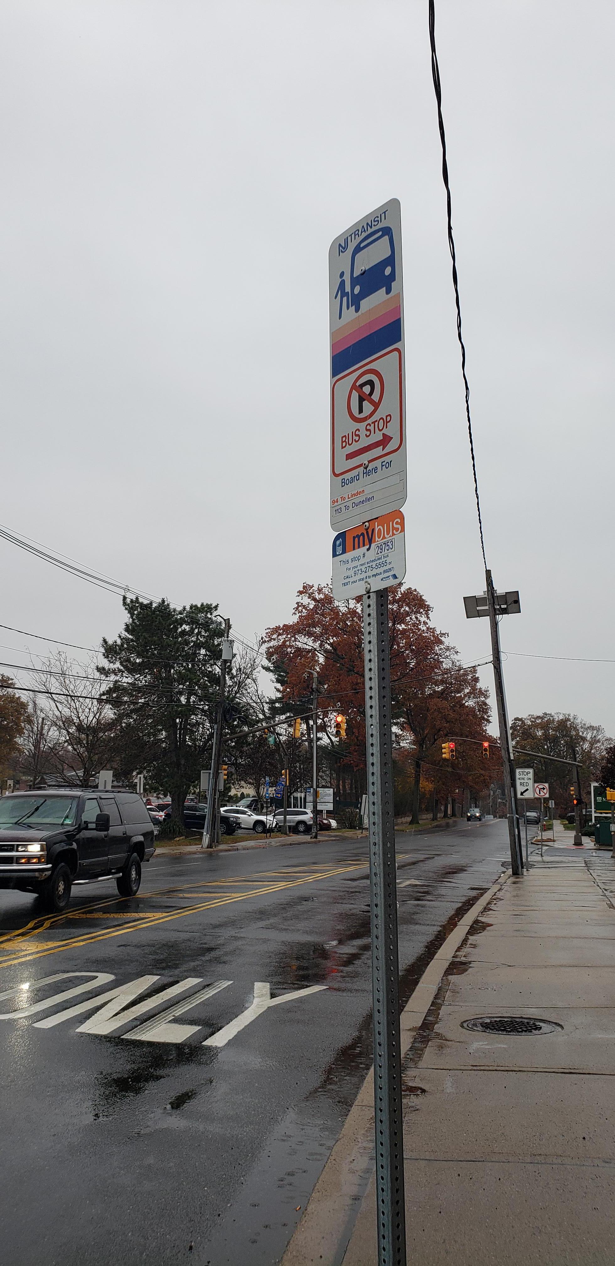 Taken by Anonymous
See Five Points at Chestnut St stop, New York - New Jersey, on the map
Public transit to Five Points at Chestnut St stop (ID: 29753) in New York - New Jersey
Looking for directions to Five Points at Chestnut St in New York - New Jersey, United States?
Download the Moovit App to find the current schedule and step-by-step directions for Bus or Train routes that pass through Five Points at Chestnut St.
Looking for the nearest stops closest to Five Points at Chestnut St ? Check out this list of closest stops to your destination: Five Points at Chestnut St; Elizabeth; Cranford.
Bus: 113, 94.Train: RVL, NC, NJCL.
We make riding on public transit to Five Points at Chestnut St easy, which is why over 1.5 million users, including users in New York - New Jersey trust Moovit as the best app for public transit.
Use the app to navigate to popular places including to the airport, hospital, stadium, grocery store, mall, coffee shop, school, college, and university.
Five Points at Chestnut St stop’s code is 29753
The first line to this stop is 94, at 7:04 AM, and the last line is 113 at 12:37 AM.
Chestnut Street, Union, NJ, USA
This stop serves NJ Transit’s lines
- Five Points at Chestnut St
Bus stop near Five Points at Chestnut St stop
- Peconic Bay Medical Center,
- Northern Blvd at Macys,
- Court St/Montague St,
- Bedford Park Blvd,
- Steinway St/Astoria Blvd,
- Saint Johns Pl/Brooklyn Av,
- Cedarhurst,
- Dyckman St,
- Hicksville LIRR Station,
- 34 St-Herald Sq,
- Riverview Dr at Rt 46,
- Lexington Av/E 94 St,
- Pearl St/Peck Slip,
- Central Park South/6 Av,
- Avenue I,
- Bradley Beach,
- 9th Street,
- World Trade Center,
- Tarrytown,
- 191 St
Popular public transit stations in New York - New Jersey
Get around New York - New Jersey by public transit!
Traveling around New York - New Jersey has never been so easy. See step by step directions as you travel to any attraction, street or major public transit station. View bus and train schedules, arrival times, service alerts and detailed routes on a map, so you know exactly how to get to anywhere in New York - New Jersey.
When traveling to any destination around New York - New Jersey use Moovit's Live Directions with Get Off Notifications to know exactly where and how far to walk, how long to wait for your line, and how many stops are left. Moovit will alert you when it's time to get off — no need to constantly re-check whether yours is the next stop.
Wondering how to use public transit in New York - New Jersey or how to pay for public transit in New York - New Jersey? Moovit public transit app can help you navigate your way with public transit easily, and at minimum cost. It includes public transit fees, ticket prices, and costs. Looking for a map of New York - New Jersey public transit lines? Moovit public transit app shows all public transit maps in New York - New Jersey with all Bus, Train, Subway, Light Rail, Ferry and Cable Car routes and stops on an interactive map.
New York - New Jersey has 6 transit type(s), including: Bus, Train, Subway, Light Rail, Ferry and Cable Car, operated by several transit agencies, including MTA Subway, Metro-North Railroad, LIRR, PATH, MTA New York City Transit - Express routes, MTA Bus, NJ Transit, NYC Ferry, NICE bus, Bee-Line Bus, NJ Transit Rail, Norwalk Transit District, CTTransit - Waterbury, Hartford Line and River Valley Transit