How to get to Flor de Cha by bus?
Click on the bus route to see step by step directions with maps, line arrival times and updated time schedules.
From Guimarães Shopping, Guimarães
65 minFrom E004 Santo Tirso, Santo Tirso, Couto (Santa Cristina e São Miguel) e Burgães
90 minFrom Polvoreira, Guimarães
76 minFrom Espaço Guimarães, Guimarães
67 minFrom Hospital da Luz Guimarães, Candoso (São Tiago) e Mascotelos
77 minFrom Estação Ferroviária de Guimarães, Guimarães
77 minFrom Estação Ferroviária de Vila Nova de Famalicão, Vila Nova de Famalicão e Calendário
77 minFrom Joane, Joane
87 minFrom Ferrara Plaza, Carvalhosa
186 minFrom Pavilhão Multiusos de Guimarães, Guimarães
72 min
How to get to Flor de Cha by train?
Click on the train route to see step by step directions with maps, line arrival times and updated time schedules.
Bus stops near Flor de Cha in Delães
Train station near Flor de Cha in Delães
- Caniços, 48 min walk,VIEW
Bus lines to Flor de Cha in Delães
- 159, Caniços (Estação),VIEW
- 162, Famalicão (Terminal),VIEW
- 354, Riba de Ave (Igreja),VIEW
- 355, Joane (Escola Bernardino Machado),VIEW
- 412, Instituto Nun'Alvres,VIEW
- 430, Vila das Aves (Estação),VIEW
- 453, Carreira (Fojo),VIEW
- 9803, Póvoa de Varzim (Terminal),VIEW
- 230, Santo Tirso (Terminal),VIEW
- 163, Riba de Ave (Igreja),VIEW
- 452, Oliveira São Mateus (Devesas),VIEW
- 455, Pedome (Escola),VIEW
- 3773, Guimarães (Terminal),VIEW
What are the closest stations to Flor de Cha?
The closest stations to Flor de Cha are:
- Albino Marques is 57 meters away, 1 min walk.
- Portela is 358 meters away, 5 min walk.
- Penide is 852 meters away, 11 min walk.
- Caniços is 3719 meters away, 48 min walk.
Which bus lines stop near Flor de Cha?
These bus lines stop near Flor de Cha: 111, 159, 162, 3775.
Which train line stops near Flor de Cha?
LINHA DE GUIMARAES (Guimaraes)
What’s the nearest bus station to Flor de Cha in Delães?
The nearest bus station to Flor de Cha in Delães is Albino Marques. It’s a 1 min walk away.
What time is the first train to Flor de Cha in Delães?
The LINHA DE GUIMARAES is the first train that goes to Flor de Cha in Delães. It stops nearby at 7:15 AM.
What time is the last train to Flor de Cha in Delães?
The LINHA DE GUIMARAES is the last train that goes to Flor de Cha in Delães. It stops nearby at 12:11 AM.
What time is the first bus to Flor de Cha in Delães?
The 230 is the first bus that goes to Flor de Cha in Delães. It stops nearby at 9:05 AM.
What time is the last bus to Flor de Cha in Delães?
The 3773 is the last bus that goes to Flor de Cha in Delães. It stops nearby at 7:38 PM.
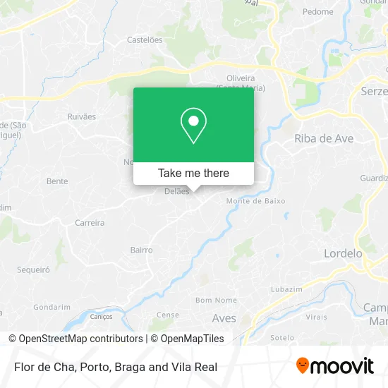
See Flor de Cha, Delães, on the map
Public Transit to Flor de Cha in Delães
Wondering how to get to Flor de Cha in Delães? Moovit helps you find the best way to get to Flor de Cha with step-by-step directions from the nearest public transit station.
Moovit provides free maps and live directions to help you navigate through your city. View schedules, routes, timetables, and find out how long does it take to get to Flor de Cha in real time.
Looking for the nearest stop or station to Flor de Cha? Check out this list of stops closest to your destination: Albino Marques; Portela; Penide; Caniços.
Bus: 111, 159, 162, 3775, 354, 355, 412, 230, 163, 452, 455, 3773.Train: LINHA DE GUIMARAES.
Want to see if there’s another route that gets you there at an earlier time? Moovit helps you find alternative routes or times. Get directions from and directions to Flor de Cha easily from the Moovit App or Website.
We make riding to Flor de Cha easy, which is why over 1.5 million users, including users in Delães, trust Moovit as the best app for public transit. You don’t need to download an individual bus app or train app, Moovit is your all-in-one transit app that helps you find the best bus time or train time available.
For information on prices of bus and train, costs and ride fares to Flor de Cha, please check the Moovit app.
Use the app to navigate to popular places including to the airport, hospital, stadium, grocery store, mall, coffee shop, school, college, and university.
Flor de Cha Address: Avenida Albino Marques Delães, 4765-096 Vila Nova de Famalicão street in Delães
- Ribapão - Sociedade Panificadora Lda,
- Unilabs Vila Nova de Famalicão - Delães,
- Multibanco,
- Talho Loureiro,
- SOCIEDADE INTERBANCARIA DE SERVICOS S A SIBS,
- Fernando Pereira Abreu Unipessoal Lda,
- Mapa de Delães,
- Rosa Matilde Moreira Araújo,
- Caleiestor - Caleiras e Estores,
- Estação de Correios de Delães,
- EB. 1 de Delães,
- Sapataria Peixoto,
- Unidade de Saúde Familiar Dallém Ave,
- Unidade de Cuidados na Comunidade Terras de Camilo,
- Escola de Karatê Shotokan de Delães,
- Unidade de Recursos Assistenciais Partilhados Vila Nova de Famalicão I,
- Escola Básica de Delães,
- Acompanhamento Fitness Online,
- Carla Manuela Monteiro e Silva,
- Restaurante Loureiro
Places Near Flor de Cha (Delães)
- Arrábida Shopping, Santa Marinha e São Pedro da Afurada,
- Rua Calouste Gulbenkian, Lordelo do Ouro e Massarelos,
- Valongo, Valongo,
- Senhor de Matosinhos, Matosinhos e Leça da Palmeira,
- MAR Shopping, Matosinhos e Leça da Palmeira,
- Estádio do Dragão, Campanhã,
- Maia, Maia,
- VILA do CONDE PORTO FASHION OUTLET, Modivas,
- Acesso ao Shopping Parque Nascente, Campanhã,
- Parque Aquatico Amarante - Aqua Aventura, Amarante,
- Canidelo, Vila Nova De Gaia,
- Leça da Palmeira, Matosinhos e Leça da Palmeira,
- Hospital Santos Silva, Vila Nova De Gaia,
- Espinho, Espinho,
- Palácio de Cristal, Lordelo do Ouro e Massarelos,
- Zoo Santo Inácio, Vila Nova De Gaia,
- El Corte Inglés de Gaia, Mafamude e Vilar do Paraíso,
- Hospital de Santo António, Cedofeita, Santo Ildefonso, Sé, Miragaia, São Nicolau e Vitória,
- Hospital da Prelada, Ramalde,
- Avintes, Vila Nova De Gaia
How to get to popular places in Porto, Braga and Vila Real with public transit
Get around Delães by public transit!
Traveling around Delães has never been so easy. See step by step directions as you travel to any attraction, street or major public transit station. View bus and train schedules, arrival times, service alerts and detailed routes on a map, so you know exactly how to get to anywhere in Delães.
When traveling to any destination around Delães use Moovit's Live Directions with Get Off Notifications to know exactly where and how far to walk, how long to wait for your line, and how many stops are left. Moovit will alert you when it's time to get off — no need to constantly re-check whether yours is the next stop.
Wondering how to use public transit in Delães or how to pay for public transit in Delães? Moovit public transit app can help you navigate your way with public transit easily, and at minimum cost. It includes public transit fees, ticket prices, and costs. Looking for a map of Delães public transit lines? Moovit public transit app shows all public transit maps in Delães with all Bus, Train, Metro, Ferry, Funicular and Gondola routes and stops on an interactive map.
Porto, Braga and Vila Real has 6 transit type(s), including: Bus, Train, Metro, Ferry, Funicular and Gondola, operated by several transit agencies, including Metro do Porto, Metro do Porto - Metrobus, CP - Comboios de Portugal, STCP, UNIR Mobilidade da Area Metropolitana do Porto, Getbus - Aerobus, Mobiave, Valpibus, TUB - Transportes Urbanos de Braga, TuViana, Guimabus, Ave Mobilidade, Cávado Mobilidade, Transdev and Câmara Municipal de Santo Tirso
Public transit lines with stations closest to Flor de Cha in Delães
Train lines with stations closest to Flor de Cha in Delães
Bus lines with stations closest to Flor de Cha in Delães
Albino Marques
 159Caniços (Estação) - Riba de Ave (São Roque)
- 162Riba de Ave (Igreja) - Famalicão (Terminal) (via Landim)
- 354Riba de Ave (Igreja) - Joane (Escola Bernardino Machado) (via Pedome)
- 355Riba de Ave (Igreja) - Joane (Escola Bernardino Machado) (via Paraíso e Vinha Dama)
- 412Caniços (Estação) - Instituto Nun'Alvres