Flower Ave & Wabash Ave stop - Thursday schedule
| Line | Direction | Time |
|---|---|---|
| 12 | Takoma Via Three Oaks | 5:13 AM |
| 12 | Takoma Via Three Oaks | 5:58 AM |
| 12 | Takoma | 6:31 AM |
| 13 | Takoma | 6:59 AM |
| 12 | Takoma | 7:14 AM |
| 13 | Takoma | 7:29 AM |
| 12 | Takoma | 7:44 AM |
| 13 | Takoma | 8:05 AM |
| 12 | Takoma | 8:14 AM |
| 13 | Takoma | 8:40 AM |
| 12 | Takoma | 8:59 AM |
| 12 | Takoma | 9:28 AM |
| 12 | Takoma | 9:58 AM |
| 12 | Takoma | 10:28 AM |
| 12 | Takoma | 10:58 AM |
| 12 | Takoma | 11:28 AM |
| 12 | Takoma | 11:58 AM |
| 12 | Takoma | 12:28 PM |
| 12 | Takoma | 12:58 PM |
| 12 | Takoma | 1:29 PM |
| 12 | Takoma | 1:59 PM |
| 12 | Takoma | 2:29 PM |
| 12 | Takoma | 2:54 PM |
| 12 | Takoma | 3:19 PM |
| 12 | Takoma | 3:39 PM |
Directions to Flower Ave & Wabash Ave stop (Montgomery County) with public transit
The following transit lines have routes that pass near Flower Ave & Wabash Ave
 Bus: 12, 13, 111, 25.
- Train: MARC.
- Metro: RED, GREEN.
How to get to Flower Ave & Wabash Ave stop by bus?
Click on the bus route to see step by step directions with maps, line arrival times and updated time schedules.
How to get to Flower Ave & Wabash Ave stop by metro?
Click on the metro route to see step by step directions with maps, line arrival times and updated time schedules.
Bus stops near Flower Ave & Wabash Ave stop in Montgomery County
- Flower Ave & Wabash Ave, 1 min walk,
- Flower Avenue And Hudson Avenue (Inbound), 3 min walk,
- Houston Ave & Flower Ave, 5 min walk,
Metro stations near Flower Ave & Wabash Ave station in Montgomery County
- Silver Spring, 46 min walk,
- Fort Totten, 59 min walk,
Train stations near Flower Ave & Wabash Ave station in Montgomery County
- Silver Spring, 46 min walk,
Bus lines to Flower Ave & Wabash Ave stop in Montgomery County
- 12, Takoma Via Three Oaks,
- 13, Takoma,
- 111, Silver Spring Metro Station,
- 25, Takoma Langley,
What are the closest stations to Flower Ave & Wabash Ave?
The closest stations to Flower Ave & Wabash Ave are:
- Flower Ave & Wabash Ave is 2 yards away, 1 min walk.
- Flower Avenue And Hudson Avenue (Inbound) is 172 yards away, 3 min walk.
- Houston Ave & Flower Ave is 377 yards away, 5 min walk.
- Silver Spring is 3853 yards away, 46 min walk.
- Fort Totten is 4993 yards away, 59 min walk.
Which bus lines stop near Flower Ave & Wabash Ave?
These bus lines stop near Flower Ave & Wabash Ave: 12, 13.
Which metro line stops near Flower Ave & Wabash Ave?
RED (Glenmont)
What’s the nearest bus station to Flower Ave & Wabash Ave in Montgomery County?
The nearest bus station to Flower Ave & Wabash Ave in Montgomery County is Flower Ave & Wabash Ave. It’s a 1 min walk away.
What time is the first metro to Flower Ave & Wabash Ave in Montgomery County?
The RED is the first metro that goes to Flower Ave & Wabash Ave in Montgomery County. It stops nearby at 5:06 AM.
What time is the last metro to Flower Ave & Wabash Ave in Montgomery County?
The RED is the last metro that goes to Flower Ave & Wabash Ave in Montgomery County. It stops nearby at 12:29 AM.
What time is the first train to Flower Ave & Wabash Ave in Montgomery County?
The MARC is the first train that goes to Flower Ave & Wabash Ave in Montgomery County. It stops nearby at 5:51 AM.
What time is the last train to Flower Ave & Wabash Ave in Montgomery County?
The MARC is the last train that goes to Flower Ave & Wabash Ave in Montgomery County. It stops nearby at 7:37 PM.
What time is the first bus to Flower Ave & Wabash Ave in Montgomery County?
The 12 is the first bus that goes to Flower Ave & Wabash Ave in Montgomery County. It stops nearby at 4:42 AM.
What time is the last bus to Flower Ave & Wabash Ave in Montgomery County?
The 12 is the last bus that goes to Flower Ave & Wabash Ave in Montgomery County. It stops nearby at 12:50 AM.
Flower Ave & Wabash Ave station
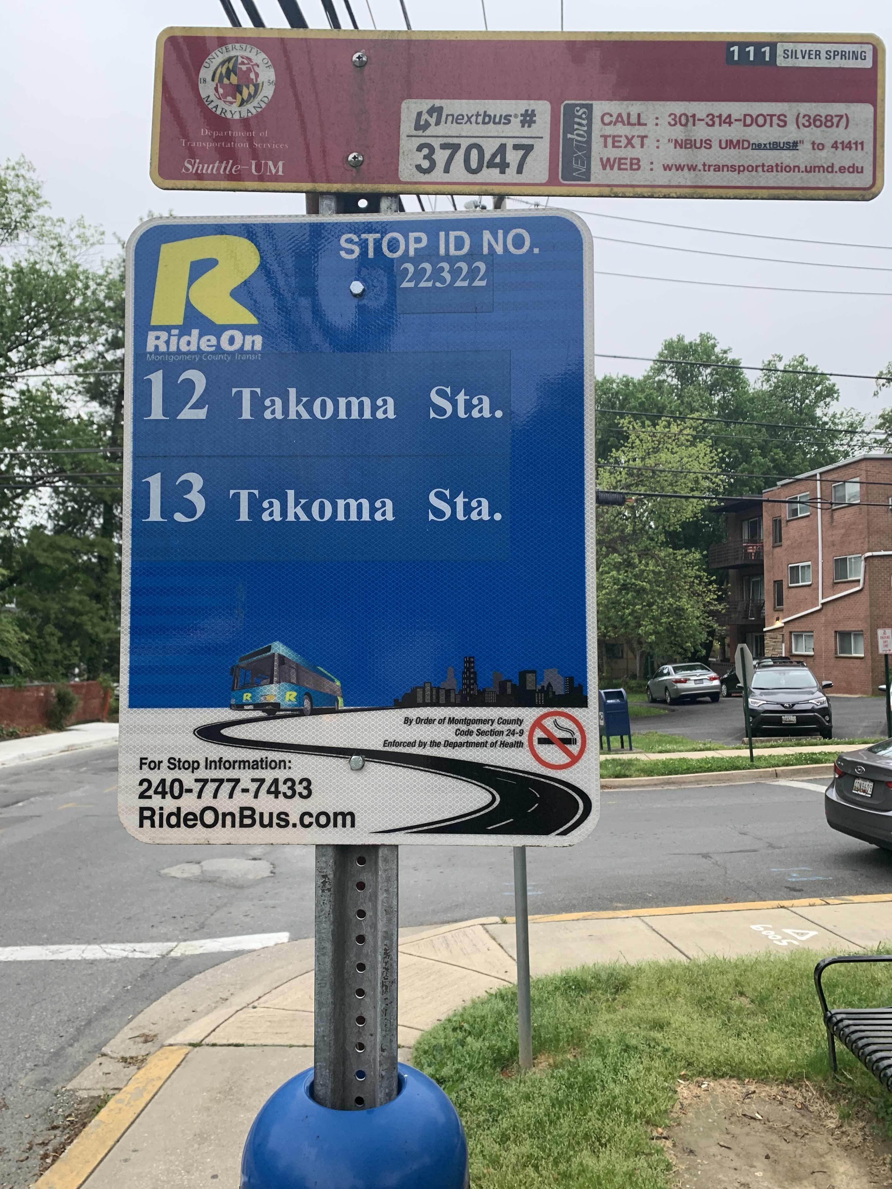 Taken by Amalia R.
See Flower Ave & Wabash Ave stop, Montgomery County, on the map
Public transit to Flower Ave & Wabash Ave stop (ID: 22321) in Montgomery County
Looking for directions to Flower Ave & Wabash Ave in Montgomery County, United States?
Download the Moovit App to find the current schedule and step-by-step directions for Bus or Metro routes that pass through Flower Ave & Wabash Ave.
Looking for the nearest stops closest to Flower Ave & Wabash Ave ? Check out this list of closest stops to your destination: Flower Ave & Wabash Ave; Flower Avenue And Hudson Avenue (Inbound); Houston Ave & Flower Ave; Silver Spring; Fort Totten.
Bus: 12, 13, 111, 25.Train: MARC.Metro: RED, GREEN.
We make riding on public transit to Flower Ave & Wabash Ave easy, which is why over 1.5 million users, including users in Montgomery County trust Moovit as the best app for public transit.
Use the app to navigate to popular places including to the airport, hospital, stadium, grocery store, mall, coffee shop, school, college, and university.
Flower Ave & Wabash Ave stop’s code is 22321
The first line to this stop is 12, at 5:13 AM, and the last line is 12 at 12:50 AM.
8400 Flower Ave, Takoma Park, MD, USA
This stop serves Montgomery County Ride On’s lines
- Flower Ave & Wabash Ave,
- Flower Avenue And Hudson Avenue (Inbound),
- Houston Ave & Flower Ave
Bus stops near Flower Ave & Wabash Ave stop
- Silver Spring,
- Fort Totten
Metro stations near Flower Ave & Wabash Ave station
- Silver Spring
Train station near Flower Ave & Wabash Ave station
- Belcamp Park And Ride,
- 36th St & Falls Rd Wb,
- O'Donnell St & Dean St,
- Maryland Ave & 25th St Sb,
- Franconia-Springfield Vre Station,
- Ashby Ponds Senior Living Community,
- 15 St Ne+Constitution Av NE,
- Reisterstown Rd & Dolfield Blvd,
- Dix St Ne+59 St NE,
- Ft Totten Station & Bus Bay E, F, G,
- S Jefferson St+#3440,
- Trinity Pkwy @ 5895 Trinity Pkwy,
- Georgia Av Nw+Decatur St NW,
- Backlick Rd @ Braddock Rd,
- Western Av+Westmoreland Cir,
- Branch Av Se+Pennsylvania Av SE,
- Harpers Ferry,
- Bwi Marshall Marc Station Sb,
- 301 Hospital Dr Eb,
- Route 1 @ Prince William Pkwy
Popular public transit stations in Montgomery County
Get around Montgomery County by public transit!
Traveling around Montgomery County has never been so easy. See step by step directions as you travel to any attraction, street or major public transit station. View bus and train schedules, arrival times, service alerts and detailed routes on a map, so you know exactly how to get to anywhere in Montgomery County.
When traveling to any destination around Montgomery County use Moovit's Live Directions with Get Off Notifications to know exactly where and how far to walk, how long to wait for your line, and how many stops are left. Moovit will alert you when it's time to get off — no need to constantly re-check whether yours is the next stop.
Wondering how to use public transit in Montgomery County or how to pay for public transit in Montgomery County? Moovit public transit app can help you navigate your way with public transit easily, and at minimum cost. It includes public transit fees, ticket prices, and costs. Looking for a map of Montgomery County public transit lines? Moovit public transit app shows all public transit maps in Montgomery County with all Bus, Train, Metro, Light Rail and Ferry routes and stops on an interactive map.
Washington, D.C. - Baltimore, MD has 5 transit type(s), including: Bus, Train, Metro, Light Rail and Ferry, operated by several transit agencies, including WMATA, Montgomery County Ride On, Fairfax Connector, TheBus, PRTC, DASH - Alexandria, Arlington Transit (ART), DC Streetcar, RTA of Central Maryland, FXBGO!, MDOT MTA, Marc, Virginia Railway Express (VRE), University of Maryland Shuttle-UM and CUE Bus - City of Fairfax