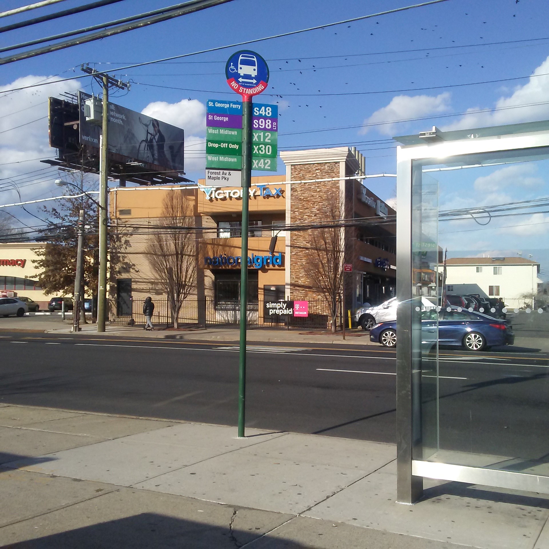
Forest Av/Maple Pkwy stop - Wednesday schedule
| Line | Direction | Time |
|---|---|---|
| S98 | Limited St George Via Forest | 6:05 AM |
| SIM33 | Greenwich Village Via West St Via 6 Av | 6:06 AM |
| SIM34 | Soho Houston St Via Church St | 6:06 AM |
| S48 | St George Ferry Via Forest | 6:11 AM |
| SIM34 | Soho Houston St Via Church St | 6:16 AM |
| S98 | Limited St George Via Forest | 6:16 AM |
| SIM33 | Greenwich Village Via West St Via 6 Av | 6:21 AM |
| S98 | Limited St George Via Forest | 6:21 AM |
| SIM34 | Soho Houston St Via Church St | 6:26 AM |
| S48 | St George Ferry Via Forest | 6:26 AM |
| S98 | Limited St George Via Forest | 6:31 AM |
| SIM33 | Greenwich Village Via West St Via 6 Av | 6:36 AM |
| SIM34 | Soho Houston St Via Church St | 6:36 AM |
| S48 | St George Ferry Via Forest | 6:36 AM |
| S98 | Limited St George Via Forest | 6:41 AM |
| S48 | St George Ferry Via Forest | 6:45 AM |
| SIM34 | Soho Houston St Via Church St | 6:46 AM |
| S98 | Limited St George Via Forest | 6:49 AM |
| SIM33 | Greenwich Village Via West St Via 6 Av | 6:51 AM |
| S48 | St George Ferry Via Forest | 6:53 AM |
| SIM34 | Soho Houston St Via Church St | 6:54 AM |
| S98 | Limited St George Via Forest | 6:57 AM |
| S98 | Limited St George Via Forest | 7:01 AM |
| SIM34 | Soho Houston St Via Church St | 7:02 AM |
| S48 | St George Ferry Via Forest | 7:06 AM |
Directions to Forest Av/Maple Pkwy stop (Staten Island) with public transit
The following transit lines have routes that pass near Forest Av/Maple Pkwy
 Bus: S48, S89, SIM33C, S98, SIM30.
How to get to Forest Av/Maple Pkwy stop by bus?
Click on the bus route to see step by step directions with maps, line arrival times and updated time schedules.
Bus stops near Forest Av/Maple Pkwy stop in Staten Island
- Forest Av/Van Pelt Av, 1 min walk,
- Forest Av/Union Av, 2 min walk,
- De Ruyter Pl/Van Pelt Av, 9 min walk,
- Richmond Av/Monsey Pl, 10 min walk,
Bus lines to Forest Av/Maple Pkwy stop in Staten Island
- S48, St George Ferry Via Forest,
- S98, Limited Richmond Av Via Forest,
- SIM30, Sunnyside - Midtown Manhattan Express,
- SIM33, Mariners Harbor - Manhattan Express,
- SIM33C, Mariners Harbor - Greenwich Village Express,
- SIM34, Mariners Harbor - Lower Manhattan Express,
- S46, St George Ferry Via Castleton,
- S96, Limited Teleport Via Castleton,
- SIM3, Midtown Via 23 St Via 6 Av,
- SIM3C, Midtown Via Church St Via 6 Av,
- S44, Marsh Avenue Richmond Hill Rd,
- S59, Huguenot Luten Av,
- S89, Limited Eltingville Hylan Bl Via Rchmond,
- S94, Limited Staten Island Mall Yukon Av,
What are the closest stations to Forest Av/Maple Pkwy?
The closest stations to Forest Av/Maple Pkwy are:
- Forest Av/Van Pelt Av is 67 yards away, 1 min walk.
- Forest Av/Union Av is 159 yards away, 2 min walk.
- De Ruyter Pl/Van Pelt Av is 746 yards away, 9 min walk.
- Richmond Av/Monsey Pl is 805 yards away, 10 min walk.
Which bus lines stop near Forest Av/Maple Pkwy?
These bus lines stop near Forest Av/Maple Pkwy: S48, S89, SIM33C.
What’s the nearest bus station to Forest Av/Maple Pkwy in Staten Island?
The nearest bus station to Forest Av/Maple Pkwy in Staten Island is Forest Av/Van Pelt Av. It’s a 1 min walk away.
What time is the first bus to Forest Av/Maple Pkwy in Staten Island?
The S48 is the first bus that goes to Forest Av/Maple Pkwy in Staten Island. It stops nearby at 3:15 AM.
What time is the last bus to Forest Av/Maple Pkwy in Staten Island?
The S48 is the last bus that goes to Forest Av/Maple Pkwy in Staten Island. It stops nearby at 2:57 AM.
Forest Av/Maple Pkwy station
 Taken by Anonymous
See Forest Av/Maple Pkwy stop, Staten Island, on the map
Public transit to Forest Av/Maple Pkwy stop in Staten Island
Looking for directions to Forest Av/Maple Pkwy in Staten Island, United States?
Download the Moovit App to find the current schedule and step-by-step directions for Bus, Subway or Train routes that pass through Forest Av/Maple Pkwy.
Looking for the nearest stops closest to Forest Av/Maple Pkwy ? Check out this list of closest stops to your destination: Forest Av/Van Pelt Av; Forest Av/Union Av; De Ruyter Pl/Van Pelt Av; Richmond Av/Monsey Pl.
Bus: S48, S89, SIM33C, S98, SIM30, SIM33, SIM34, S46, S96, SIM3, SIM3C, S44, S59.
We make riding on public transit to Forest Av/Maple Pkwy easy, which is why over 1.5 million users, including users in Staten Island trust Moovit as the best app for public transit.
Use the app to navigate to popular places including to the airport, hospital, stadium, grocery store, mall, coffee shop, school, college, and university.
The first line to this stop is S98, at 6:05 AM, and the last line is S48 at 5:59 AM.
278 Maple Pkwy, Staten Island, New York, NY, USA
This stop serves MTA Bus and MTA New York City Transit - Express routes’s lines
- Forest Av/Van Pelt Av,
- Forest Av/Union Av,
- De Ruyter Pl/Van Pelt Av,
- Richmond Av/Monsey Pl
Bus stops near Forest Av/Maple Pkwy stop
- 103 St-Corona Plaza,
- Midtown West/W 39th St-Pier 79,
- Pike St/Cherry St,
- Montclair Heights,
- Roosevelt Av/74 St,
- Freeman St,
- Gates Av/Broadway,
- Fleetwood,
- 30th St at Pleasant Ave,
- Old Country Rd / E Gate,
- Broadway/Worth St,
- Lafayette St/Astor Pl,
- Peekskill,
- State St. at Housatonic Community College,
- Delancey St-Essex St,
- Dover Plains,
- W 135 St/Broadway,
- Katonah,
- Rector St,
- Lafayette Av
Popular public transit stations in Staten Island
Get around Staten Island by public transit!
Traveling around Staten Island has never been so easy. See step by step directions as you travel to any attraction, street or major public transit station. View bus and train schedules, arrival times, service alerts and detailed routes on a map, so you know exactly how to get to anywhere in Staten Island.
When traveling to any destination around Staten Island use Moovit's Live Directions with Get Off Notifications to know exactly where and how far to walk, how long to wait for your line, and how many stops are left. Moovit will alert you when it's time to get off — no need to constantly re-check whether yours is the next stop.
Wondering how to use public transit in Staten Island or how to pay for public transit in Staten Island? Moovit public transit app can help you navigate your way with public transit easily, and at minimum cost. It includes public transit fees, ticket prices, and costs. Looking for a map of Staten Island public transit lines? Moovit public transit app shows all public transit maps in Staten Island with all Bus, Train, Subway, Light Rail, Ferry and Cable Car routes and stops on an interactive map.
New York - New Jersey has 6 transit type(s), including: Bus, Train, Subway, Light Rail, Ferry and Cable Car, operated by several transit agencies, including MTA Subway, Metro-North Railroad, LIRR, PATH, MTA New York City Transit - Express routes, MTA Bus, NJ Transit, NYC Ferry, NICE bus, Bee-Line Bus, NJ Transit Rail, Norwalk Transit District, CTTransit - Waterbury, Hartford Line and River Valley Transit