Front St + Maple Ave. stop - Tuesday schedule
| Line | Direction | Time |
|---|---|---|
| N49 | Hempstead | 6:03 AM |
| N49 | Hempstead | 6:33 AM |
| N49 | Hempstead | 7:03 AM |
| N48 | Hempstead | 7:36 AM |
| N49 | Hempstead | 8:08 AM |
| N48 | Hempstead | 8:36 AM |
| N49 | Hempstead | 9:08 AM |
| N48 | Hempstead | 9:35 AM |
| N49 | Hempstead | 10:06 AM |
| N48 | Hempstead | 10:35 AM |
| N49 | Hempstead | 11:06 AM |
| N48 | Hempstead | 11:35 AM |
| N49 | Hempstead | 12:06 PM |
| N48 | Hempstead | 12:35 PM |
| N49 | Hempstead | 1:06 PM |
| N48 | Hempstead | 1:35 PM |
| N49 | Hempstead | 2:06 PM |
| N48 | Hempstead | 2:35 PM |
| N49 | Hempstead | 3:06 PM |
| N48 | Hempstead | 3:40 PM |
| N49 | Hempstead | 4:10 PM |
| N48 | Hempstead | 4:40 PM |
| N49 | Hempstead | 5:10 PM |
| N48 | Hempstead | 5:40 PM |
| N49 | Hempstead | 6:10 PM |
Directions to Front St + Maple Ave. stop (Uniondale) with public transit
The following transit lines have routes that pass near Front St + Maple Ave.
 Bus: N43, N43X, N48, N49.
- Train: HEMPSTEAD BRANCH, WEST HEMPSTEAD BRANCH.
How to get to Front St + Maple Ave. stop by bus?
Click on the bus route to see step by step directions with maps, line arrival times and updated time schedules.
How to get to Front St + Maple Ave. stop by train?
Click on the train route to see step by step directions with maps, line arrival times and updated time schedules.
Bus stops near Front St + Maple Ave. stop in Uniondale
- Front St + Greengrove Ave, 2 min walk,
- Front St / Uniondale, 3 min walk,
Train stations near Front St + Maple Ave. station in Uniondale
- Hempstead, 22 min walk,
- West Hempstead, 52 min walk,
Bus lines to Front St + Maple Ave. stop in Uniondale
- N48, Front St / Carman Av,
- N49, Front St / Newbridge Rd,
- N43, Freeport,
- N43X, Roosevelt Field Exp,
What are the closest stations to Front St + Maple Ave.?
The closest stations to Front St + Maple Ave. are:
- Front St + Greengrove Ave stop is 83 yards away, 2 min walk.
- Front St / Uniondale stop is 232 yards away, 3 min walk.
- Hempstead station is 1853 yards away, 22 min walk.
- West Hempstead station is 4497 yards away, 52 min walk.
Which bus lines stop near Front St + Maple Ave.?
These bus lines stop near Front St + Maple Ave.: N43, N43X, N48, N49.
Which train line stops near Front St + Maple Ave.?
HEMPSTEAD BRANCH (Hempstead)
What’s the nearest train station to Front St + Maple Ave. in Uniondale?
The nearest train station to Front St + Maple Ave. in Uniondale is Hempstead. It’s a 22 min walk away.
What’s the nearest bus station to Front St + Maple Ave. in Uniondale?
The nearest bus station to Front St + Maple Ave. in Uniondale is Front St + Greengrove Ave. It’s a 2 min walk away.
What time is the first train to Front St + Maple Ave. in Uniondale?
The HEMPSTEAD BRANCH is the first train that goes to Front St + Maple Ave. in Uniondale. It stops nearby at 3:25 AM.
What time is the last train to Front St + Maple Ave. in Uniondale?
The HEMPSTEAD BRANCH is the last train that goes to Front St + Maple Ave. in Uniondale. It stops nearby at 3:29 AM.
What time is the first bus to Front St + Maple Ave. in Uniondale?
The N49 is the first bus that goes to Front St + Maple Ave. in Uniondale. It stops nearby at 4:28 AM.
What time is the last bus to Front St + Maple Ave. in Uniondale?
The N43 is the last bus that goes to Front St + Maple Ave. in Uniondale. It stops nearby at 12:18 AM.
Front St + Maple Ave. station
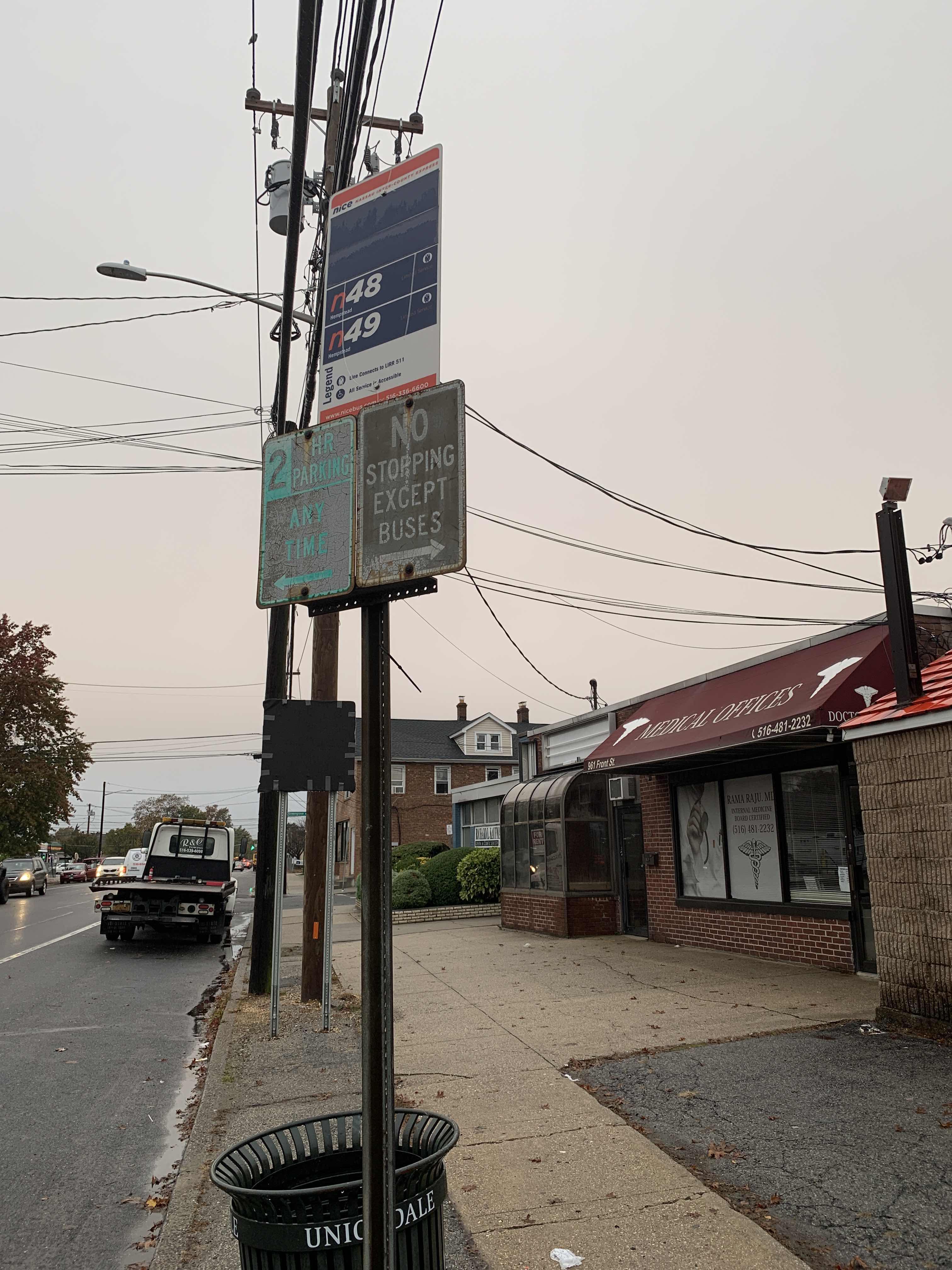 Taken by Anthony T.
See Front St + Maple Ave. stop, Uniondale, on the map
Public transit to Front St + Maple Ave. stop (ID: 825) in Uniondale
Looking for directions to Front St + Maple Ave. in Uniondale, United States?
Download the Moovit App to find the current schedule and step-by-step directions for Bus or Train routes that pass through Front St + Maple Ave..
Looking for the nearest stops closest to Front St + Maple Ave. ? Check out this list of closest stops to your destination: Front St + Greengrove Ave; Front St / Uniondale; Hempstead; West Hempstead.
Bus: N43, N43X, N48, N49.Train: HEMPSTEAD BRANCH, WEST HEMPSTEAD BRANCH.
We make riding on public transit to Front St + Maple Ave. easy, which is why over 1.7 billion users, including users in Uniondale trust Moovit as the best app for public transit.
Use the app to navigate to popular places including to the airport, hospital, stadium, grocery store, mall, coffee shop, school, college, and university.
Front St + Maple Ave. stop’s code is 825
The first line to this stop is N49, at 6:03 AM, and the last line is N49 at 5:33 AM.
964 Front Street, Uniondale, NY, USA
This stop serves NICE bus’s lines
- Front St + Greengrove Ave,
- Front St / Uniondale
Bus stops near Front St + Maple Ave. stop
- Hempstead,
- West Hempstead
Train stations near Front St + Maple Ave. station
- Island Park,
- Waverly Ave/Long Island Ave,
- Main St /65-21 Main St,
- Old Bridge Park & Ride (Southbound),
- Gun Hill Rd,
- Grand St,
- E 34 St/1 Av,
- Fairfield Metro,
- Amityville,
- Amagansett,
- Auburndale,
- 161 St-Yankee Stadium,
- Adams St/Brooklyn Supreme Court,
- 86 St/24 Av,
- 181 St,
- Broadway/Lorimer St,
- Tramway Plaza East,
- New York Av/Lenox Rd,
- Metropolitan Av,
- Westampton - Exit 5 Park and Ride
Popular public transit stations in Uniondale
Get around Uniondale by public transit!
Traveling around Uniondale has never been so easy. See step by step directions as you travel to any attraction, street or major public transit station. View bus and train schedules, arrival times, service alerts and detailed routes on a map, so you know exactly how to get to anywhere in Uniondale.
When traveling to any destination around Uniondale use Moovit's Live Directions with Get Off Notifications to know exactly where and how far to walk, how long to wait for your line, and how many stops are left. Moovit will alert you when it's time to get off — no need to constantly re-check whether yours is the next stop.
Wondering how to use public transit in Uniondale or how to pay for public transit in Uniondale? Moovit public transit app can help you navigate your way with public transit easily, and at minimum cost. It includes public transit fees, ticket prices, and costs. Looking for a map of Uniondale public transit lines? Moovit public transit app shows all public transit maps in Uniondale with all Bus, Train, Subway, Light Rail, Ferry and Cable Car routes and stops on an interactive map.
New York - New Jersey has 6 transit type(s), including: Bus, Train, Subway, Light Rail, Ferry and Cable Car, operated by several transit agencies, including MTA Subway, Metro-North Railroad, LIRR, PATH, MTA New York City Transit - Express routes, MTA Bus, NJ Transit, NYC Ferry, NICE bus, Bee-Line Bus, NJ Transit Rail, Norwalk Transit District, CTTransit - Waterbury-Meriden, Hartford Line and River Valley Transit