Gare De Arles station - Friday schedule
| Line | Direction | Time |
|---|---|---|
| K7 | 879503 | 05:28 |
| K7 | 879507 | 06:12 |
| K7 | 879582 | 06:51 |
| K7 | 879515 | 07:12 |
| K9 | 876550 | 07:17 |
| K9 | 876532 | 07:45 |
| K14 | 17700 | 07:50 |
| K4 | 886557 | 08:12 |
| K7 | 879504 | 08:46 |
| K7 | 879527 | 09:10 |
| K9 | 876554 | 09:19 |
| K4 | 886556 | 09:47 |
| K14 | 17701 | 10:11 |
| K4 | 886565 | 11:33 |
| K7 | 879516 | 11:47 |
| K7 | 879533 | 12:11 |
| K4 | 886560 | 12:47 |
| K7 | 879539 | 13:12 |
| K9 | 876558 | 13:18 |
| K14 | 17702 | 13:49 |
| K4 | 886569 | 14:17 |
| K4 | 886568 | 14:47 |
| K7 | 879522 | 15:47 |
| K7 | 879545 | 16:23 |
| K9 | 876542 | 16:44 |
Directions to Gare De Arles with public transportation
The following transit lines have routes that pass near Gare De Arles
How to get to Gare De Arles by bus?
Click on the bus route to see step by step directions with maps, line arrival times and updated time schedules.
How to get to Gare De Arles by train?
Click on the train route to see step by step directions with maps, line arrival times and updated time schedules.
Bus stops near Gare De Arles
- Gare Sncf, 2 min walk,
- Collège Mistral, 5 min walk,
- Stalingrad, 9 min walk,
Bus lines to Gare De Arles
- 702, Arles - Salon-De-Provence,
- 703, Arles - Port-Saint-Louis-Du-Rhône,
- 704, Cavaillon - Arles,
- 707, Avignon - Saint-Rémy-De-Provence,
- 1, 1 - Gare SNCF <> Barriol,
- A10, AGGLO 10 - Salin de Giraud Camargue <> Arles Gare SNCF,
- 11, 11 - Gare SNCF <> Parking des Minimes,
- A20, AGGLO 20 - Arles Gare SNCF <> Tarascon Gare SNCF,
- A30, AGGLO 30 - St Martin de Crau Gare SNCF <> Arles Gare SNCF,
- A50, AGGLO 50 - Stes Maries de la Mer - Les Massoucles <> Arles - Gare SNCF,
- 106, 106 - Salin de Giraud <> Arles,
- 108, 108 - Arles <> St Martin de Crau,
- 101, Raphele - Moulès - Goudègues - Rte Eyguières,
- 103, Gare Sncf Tarascon,
- 2, Hôpital,
- 4, Cc La Plaine,
- 5, Tournesol,
- 12, Barriol,
- 109, Clémenceau,
What are the closest stations to Gare De Arles?
The closest stations to Gare De Arles are:
- Gare Sncf is 81 meters away, 2 min walk.
- Collège Mistral is 317 meters away, 5 min walk.
- Stalingrad is 681 meters away, 9 min walk.
Which bus line stops near Gare De Arles?
A20 (Gare Sncf)
Which train line stops near Gare De Arles?
K4 (886561)
What’s the nearest bus station to Gare De Arles?
The nearest bus station to Gare De Arles is Gare Sncf. It’s a 2 min walk away.
What time is the first bus to Gare De Arles?
The A10 is the first bus that goes to Gare De Arles. It stops nearby at 7:46 AM.
What time is the last bus to Gare De Arles?
The A50 is the last bus that goes to Gare De Arles. It stops nearby at 10:49 PM.
See Gare De Arles on the map
Public transit to Gare De Arles station
Looking for directions to Gare De Arles in Arles, France?
Download the Moovit App to find the current schedule and step-by-step directions for Train or Bus routes that pass through Gare De Arles.
Looking for the nearest stops closest to Gare De Arles ? Check out this list of closest stops to your destination: Gare Sncf; Collège Mistral; Stalingrad.
Bus: A20, 702, 703, 704, 707, 1, A10, 11, A30, 101, 103, 2, 4, 5, 12, 109.Train: K4.
We make riding on public transit to Gare De Arles easy, which is why over 1.5 million users, including users in Arles trust Moovit as the best app for public transit.
Use the app to navigate to popular places including to the airport, hospital, stadium, grocery store, mall, coffee shop, school, college, and university.
The station has the following entrances: Avenue Paulin Talabot
The first line to this station is K7, at 05:28, and the last line is K7 at 21:45.
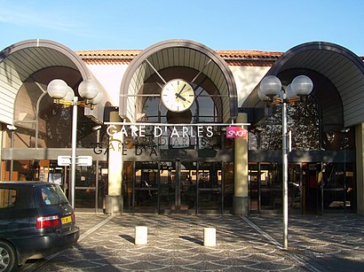
Gare d'Arles, Arles, France
This station serves SNCF VOYAGEURS’s lines
Popular routes from Gare De Arles
Popular public transit stations in Arles
Get around Arles by public transit!
Traveling around Arles has never been so easy. See step by step directions as you travel to any attraction, street or major public transit station. View bus and train schedules, arrival times, service alerts and detailed routes on a map, so you know exactly how to get to anywhere in Arles.
When traveling to any destination around Arles use Moovit's Live Directions with Get Off Notifications to know exactly where and how far to walk, how long to wait for your line, and how many stops are left. Moovit will alert you when it's time to get off — no need to constantly re-check whether yours is the next stop.
Wondering how to use public transit in Arles or how to pay for public transit in Arles? Moovit public transit app can help you navigate your way with public transit easily, and at minimum cost. It includes public transit fees, ticket prices, and costs. Looking for a map of Arles public transit lines? Moovit public transit app shows all public transit maps in Arles with all Bus, Train, Metro, Light Rail, Ferry and Gondola routes and stops on an interactive map.
Marseille has 6 transit type(s), including: Bus, Train, Metro, Light Rail, Ferry and Gondola, operated by several transit agencies, including RTM, Ulysse, Réseau Mistral, ZOU ! Express, ZOU ! Proximité, ZOU ! Scolaire, SNCF VOYAGEURS, Lecar / Pays d'Aix Mobilité, Aix en Bus, Busdel'agglo, Les bus des Cigales, Les bus des Collines, CAA, Lecar / Cartreize and Ciotabus