Grand & Streeter (West) stop - Saturday schedule
| Line | Direction | Time |
|---|---|---|
| 29 | 95th Red Line Station (East) | 5:02 AM |
| 66 | Chicago & Austin Terminal (South) | 5:09 AM |
| 29 | 95th Red Line Station (East) | 5:25 AM |
| 66 | Chicago & Austin Terminal (South) | 5:30 AM |
| 29 | 95th Red Line Station (East) | 5:48 AM |
| 66 | Chicago & Austin Terminal (South) | 5:50 AM |
| 65 | Grand & Nordica Terminal (South) | 5:52 AM |
| 66 | Chicago & Austin Terminal (South) | 6:10 AM |
| 29 | 95th Red Line Station (East) | 6:10 AM |
| 65 | Grand & Nordica Terminal (South) | 6:16 AM |
| 66 | Chicago & Austin Terminal (South) | 6:29 AM |
| 29 | 95th Red Line Station (East) | 6:31 AM |
| 65 | Grand & Nordica Terminal (South) | 6:41 AM |
| 66 | Chicago & Austin Terminal (South) | 6:46 AM |
| 29 | 95th Red Line Station (East) | 6:52 AM |
| 66 | Chicago & Austin Terminal (South) | 7:02 AM |
| 65 | Grand & Nordica Terminal (South) | 7:05 AM |
| 29 | 95th Red Line Station (East) | 7:13 AM |
| 66 | Chicago & Austin Terminal (South) | 7:17 AM |
| 66 | Chicago & Austin Terminal (South) | 7:26 AM |
| 65 | Grand & Nordica Terminal (South) | 7:28 AM |
| 29 | 95th Red Line Station (East) | 7:34 AM |
| 66 | Chicago & Austin Terminal (South) | 7:37 AM |
| 66 | Chicago & Austin Terminal (South) | 7:45 AM |
| 65 | Grand & Nordica Terminal (South) | 7:48 AM |
Directions to Grand & Streeter (West) stop (Chicago) with public transit
The following transit lines have routes that pass near Grand & Streeter (West)
 Bus: 2, 29, 65, 66, 124.
- Train: ME, UP-N, LAKESHORE, MONON.
- Chicago 'L': RED LINE, BROWN LINE, GREEN LINE, ORANGE LINE, PINK LINE.
How to get to Grand & Streeter (West) stop by bus?
Click on the bus route to see step by step directions with maps, line arrival times and updated time schedules.
How to get to Grand & Streeter (West) stop by train?
Click on the train route to see step by step directions with maps, line arrival times and updated time schedules.
How to get to Grand & Streeter (West) stop by Chicago 'L'?
Click on the Chicago 'L' route to see step by step directions with maps, line arrival times and updated time schedules.
Bus stops near Grand & Streeter (West) stop in Chicago
- Navy Pier Terminal (Ne), 2 min walk,
- Navy Pier Terminal (North), 3 min walk,
- Mcclurg & Grand (North), 7 min walk,
Chicago 'L' stations near Grand & Streeter (West) station in Chicago
- Grand-Red, 17 min walk,
- Washington/Wabash, 27 min walk,
Train stations near Grand & Streeter (West) station in Chicago
- Millennium Station, 23 min walk,
Bus lines to Grand & Streeter (West) stop in Chicago
- 2, Midway Plaisance & Cottage Grove (East),
- 29, Navy Pier Terminal (North),
- 66, Navy Pier Terminal (North),
- 124, Clinton & Quincy (South),
- 65, Navy Pier Terminal (North),
- 120, Mcclurg & Huron (North),
- 121, Adams & Canal (West),
What are the closest stations to Grand & Streeter (West)?
The closest stations to Grand & Streeter (West) are:
- Navy Pier Terminal (Ne) is 145 yards away, 2 min walk.
- Navy Pier Terminal (North) is 189 yards away, 3 min walk.
- Mcclurg & Grand (North) is 518 yards away, 7 min walk.
- Grand-Red is 1425 yards away, 17 min walk.
- Millennium Station is 1903 yards away, 23 min walk.
- Washington/Wabash is 2229 yards away, 27 min walk.
Which bus lines stop near Grand & Streeter (West)?
These bus lines stop near Grand & Streeter (West): 2, 29, 65, 66.
Which train lines stop near Grand & Streeter (West)?
These train lines stop near Grand & Streeter (West): ME, UP-N.
Which Chicago 'L' line stops near Grand & Streeter (West)?
RED LINE (Howard)
What’s the nearest Chicago 'L' station to Grand & Streeter (West) in Chicago?
The nearest Chicago 'L' station to Grand & Streeter (West) in Chicago is Grand-Red. It’s a 17 min walk away.
What’s the nearest train station to Grand & Streeter (West) in Chicago?
The nearest train station to Grand & Streeter (West) in Chicago is Millennium Station. It’s a 23 min walk away.
What’s the nearest bus station to Grand & Streeter (West) in Chicago?
The nearest bus station to Grand & Streeter (West) in Chicago is Navy Pier Terminal (Ne). It’s a 2 min walk away.
What time is the first Chicago 'L' to Grand & Streeter (West) in Chicago?
The RED LINE is the first Chicago 'L' that goes to Grand & Streeter (West) in Chicago. It stops nearby at 3:02 AM.
What time is the last Chicago 'L' to Grand & Streeter (West) in Chicago?
The RED LINE is the last Chicago 'L' that goes to Grand & Streeter (West) in Chicago. It stops nearby at 3:21 AM.
What time is the first train to Grand & Streeter (West) in Chicago?
The ME is the first train that goes to Grand & Streeter (West) in Chicago. It stops nearby at 4:50 AM.
What time is the last train to Grand & Streeter (West) in Chicago?
The ME is the last train that goes to Grand & Streeter (West) in Chicago. It stops nearby at 12:58 AM.
What time is the first bus to Grand & Streeter (West) in Chicago?
The 66 is the first bus that goes to Grand & Streeter (West) in Chicago. It stops nearby at 4:48 AM.
What time is the last bus to Grand & Streeter (West) in Chicago?
The 66 is the last bus that goes to Grand & Streeter (West) in Chicago. It stops nearby at 12:52 AM.
Grand & Streeter (West) station
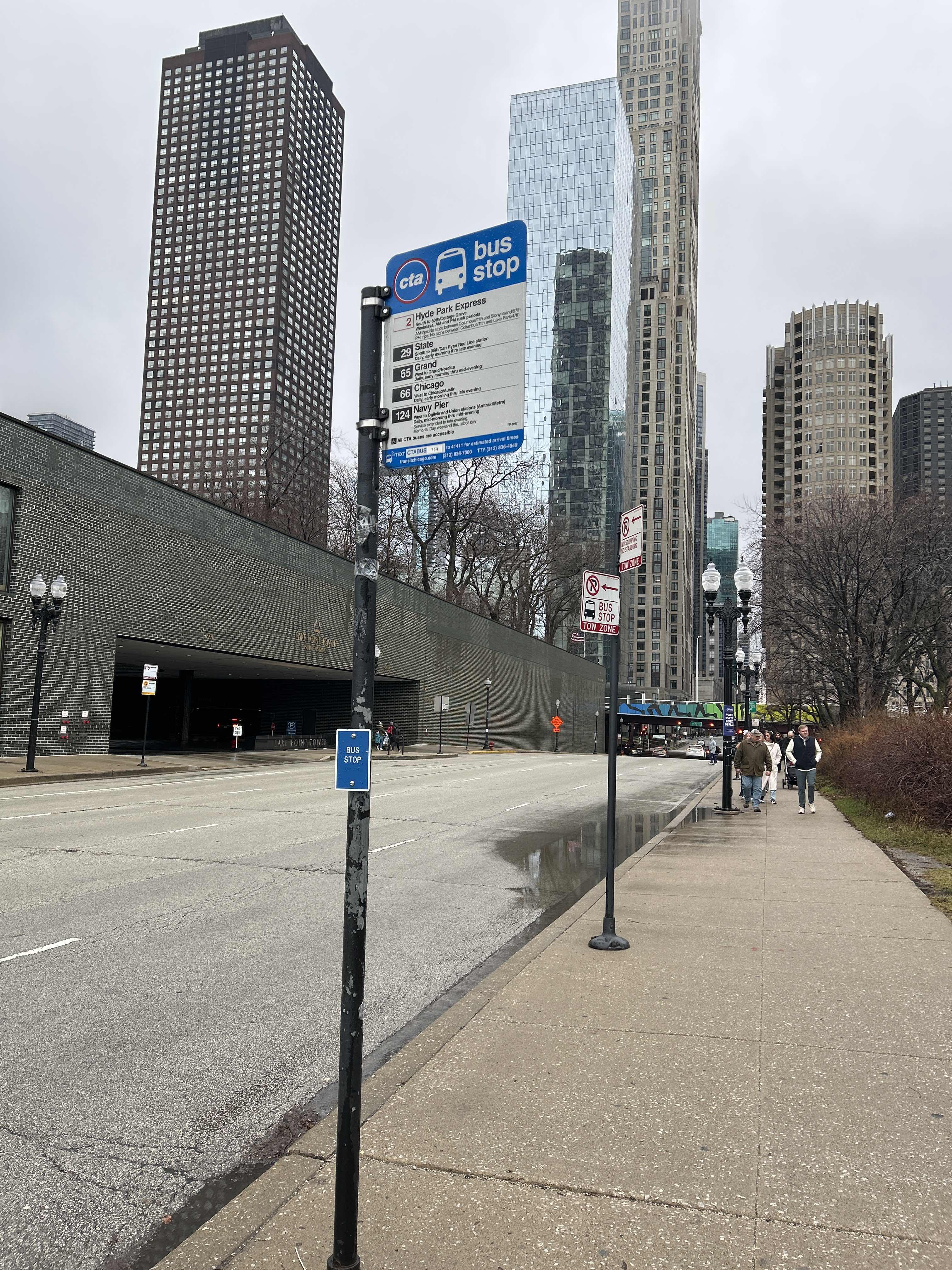 Taken by Anonymous
See Grand & Streeter (West) stop, Chicago, on the map
Public transit to Grand & Streeter (West) stop (ID: 759) in Chicago
Looking for directions to Grand & Streeter (West) in Chicago, United States?
Download the Moovit App to find the current schedule and step-by-step directions for Bus, Chicago 'L' or Train routes that pass through Grand & Streeter (West).
Looking for the nearest stops closest to Grand & Streeter (West) ? Check out this list of closest stops to your destination: Navy Pier Terminal (Ne); Navy Pier Terminal (North); Mcclurg & Grand (North); Grand-Red; Millennium Station; Washington/Wabash.
Bus: 2, 29, 65, 66, 124.Train: ME, UP-N, LAKESHORE, MONON.Chicago 'L': RED LINE, BROWN LINE, GREEN LINE, ORANGE LINE, PINK LINE, PURPLE LINE.
We make riding on public transit to Grand & Streeter (West) easy, which is why over 1.5 million users, including users in Chicago trust Moovit as the best app for public transit.
Use the app to navigate to popular places including to the airport, hospital, stadium, grocery store, mall, coffee shop, school, college, and university.
Grand & Streeter (West) stop’s code is 759
The first line to this stop is 29, at 5:02 AM, and the last line is 66 at 12:50 AM.
Lakefront Trail Connector, Central, Chicago, IL, USA
This stop serves CTA’s lines
- Navy Pier Terminal (Ne),
- Navy Pier Terminal (North),
- Mcclurg & Grand (North)
Bus stops near Grand & Streeter (West) stop
- Grand-Red,
- Washington/Wabash
Chicago 'L' stations near Grand & Streeter (West) station
- Millennium Station
Train station near Grand & Streeter (West) station
- North Ave & 5th Ave,
- Western Ave & 87th St,
- University Park Metra Station,
- 147th St & Cicero Ave,
- North Ave & Narragansett (West),
- Kedzie & Foster (North),
- Columbus (Mid) & E. Wacker (South),
- Higgins/Washington,
- Harlem Ave & 63rd St,
- Golf Rd & Elmhurst Rd,
- Ashland & Webster (North),
- 71st Street & Central Park (West),
- Torrence & 105th Street (South),
- 6900 W 65th Street (East),
- 59th Street & Halsted (West),
- Racine,
- Harlem / Milwaukee,
- Jarvis,
- Jeffery & 73rd Street (South),
- Oakton Community College
Popular public transit stations in Chicago
Get around Chicago by public transit!
Traveling around Chicago has never been so easy. See step by step directions as you travel to any attraction, street or major public transit station. View bus and train schedules, arrival times, service alerts and detailed routes on a map, so you know exactly how to get to anywhere in Chicago.
When traveling to any destination around Chicago use Moovit's Live Directions with Get Off Notifications to know exactly where and how far to walk, how long to wait for your line, and how many stops are left. Moovit will alert you when it's time to get off — no need to constantly re-check whether yours is the next stop.
Wondering how to use public transit in Chicago or how to pay for public transit in Chicago? Moovit public transit app can help you navigate your way with public transit easily, and at minimum cost. It includes public transit fees, ticket prices, and costs. Looking for a map of Chicago public transit lines? Moovit public transit app shows all public transit maps in Chicago with all Bus, Train and Chicago 'L' routes and stops on an interactive map.
Chicago has 3 transit type(s), including: Bus, Train and Chicago 'L', operated by several transit agencies, including CTA 'L', Metra, Northern Indiana Commuter Transportation District, CTA, PACE, O'Hare International Airport Shuttle Bus, Gary Public Transit, Amtrak, River Valley Metro, Valpo Transit, DeKalb Public Transit, FlixBus-us, Greyhound-us, Van Galder (Coach USA) and Wisconsin Coach Lines