Directions to Infobras Informatica (Araucária) with public transportation
The following transit lines have routes that pass near Infobras Informatica
How to get to Infobras Informatica by bus?
Click on the bus route to see step by step directions with maps, line arrival times and updated time schedules.
From Terminal Tatuquara, Tatuquara
40 minFrom Volvo, Cic
57 minFrom Rua Nicola Pellanda, Umbará
92 minFrom Rua Luís Franceschi 657, Araucária
50 minFrom New Holland Cnh Capital, Cic
71 minFrom Bairro Thomaz Coelho, Araucária
50 minFrom Avenida Juscelino Kubitschek de Oliveira, Cic
62 minFrom Fazenda Rio Grande, Fazenda Rio Grande
77 minFrom Rua Cyro Correia Pereira 667, Cic
63 minFrom Tatuquara, Tatuquara
60 min
Bus stops near Infobras Informatica in Araucária
Bus lines to Infobras Informatica in Araucária
- F04 JARDINEIRA, Rua Hortência → Terminal Central Araucária,VIEW
- 24 SÃO FRANCISCO, Terminal Central Araucária ↺ São Francisco (Circular),VIEW
- 02 LINHÃO 02 (ANGÉLICA / TUPY), Terminal Vila Angélica → Tupy,VIEW
- 20 PLANALTO / MINAS GERAIS, Terminal Central Araucária ↺ Planalto via Minas Gerais (Circular),VIEW
- 25 COSTEIRA / D'AMPEZZO, Terminal Central Araucária ↺ Costeira / D'Ampezzo (Circular),VIEW
- 20 PLANALTO / GRALHA AZUL, Açougue Maranhão → Terminal Central Araucária,VIEW
What are the closest stations to Infobras Informatica?
The closest stations to Infobras Informatica are:
- Rua Capivari, 248 is 13 meters away, 1 min walk.
- Avenida Archelau De Almeida Tôrres, 2452 is 371 meters away, 5 min walk.
- Rua Maranhão, 2673 is 552 meters away, 8 min walk.
Which bus lines stop near Infobras Informatica?
These bus lines stop near Infobras Informatica: 02 LINHÃO 02 (ANGÉLICA / TUPY), 20 PLANALTO / GRALHA AZUL, 24 SÃO FRANCISCO.
What’s the nearest bus station to Infobras Informatica in Araucária?
The nearest bus station to Infobras Informatica in Araucária is Rua Capivari, 248. It’s a 1 min walk away.
What time is the first bus to Infobras Informatica in Araucária?
The 24 SÃO FRANCISCO is the first bus that goes to Infobras Informatica in Araucária. It stops nearby at 4:21 AM.
What time is the last bus to Infobras Informatica in Araucária?
The 02 LINHÃO 02 (ANGÉLICA / TUPY) is the last bus that goes to Infobras Informatica in Araucária. It stops nearby at 1:09 AM.
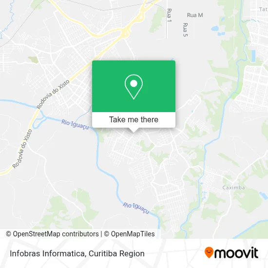
See Infobras Informatica, Araucária, on the map
Public Transit to Infobras Informatica in Araucária
Wondering how to get to Infobras Informatica in Araucária? Moovit helps you find the best way to get to Infobras Informatica with step-by-step directions from the nearest public transit station.
Moovit provides free maps and live directions to help you navigate through your city. View schedules, routes, timetables, and find out how long does it take to get to Infobras Informatica in real time.
Looking for the nearest stop or station to Infobras Informatica? Check out this list of stops closest to your destination: Rua Capivari; Avenida Archelau De Almeida Tôrres; Rua Maranhão.
Bus: 02 LINHÃO 02 (ANGÉLICA / TUPY), 20 PLANALTO / GRALHA AZUL, 24 SÃO FRANCISCO, F04 JARDINEIRA, 20 PLANALTO / MINAS GERAIS, 25 COSTEIRA / D'AMPEZZO.
Want to see if there’s another route that gets you there at an earlier time? Moovit helps you find alternative routes or times. Get directions from and directions to Infobras Informatica easily from the Moovit App or Website.
We make riding to Infobras Informatica easy, which is why over 1.5 million users, including users in Araucária, trust Moovit as the best app for public transit. You don’t need to download an individual bus app or train app, Moovit is your all-in-one transit app that helps you find the best bus time or train time available.
For information on prices of bus, costs and ride fares to Infobras Informatica, please check the Moovit app.
Use the app to navigate to popular places including to the airport, hospital, stadium, grocery store, mall, coffee shop, school, college, and university.
Infobras Informatica Address: Rua Capivari, 238 Iguaçu Araucária-PR 83701-440 street in Araucária
- Ilario Lanches,
- My House,
- Aviário Iung,
- Funilaria Construtec,
- Equalize - Soluções Inteligentes Em Rh,
- Alp Lataria e Pintura,
- Rua Londrina,
- Condomínio Residencial Belle Ville,
- Comercio e Distribuidora Fonte Nova,
- Veraneio Modas,
- Regi Car,
- Império Frios,
- Sids Beer Distribuidora de Bebidas,
- La Frutas e Verduras,
- Belíssima Hair & Cosméticos,
- Tri-NATO,
- Trial Ambiental,
- Cantinho da Costura,
- Cicles Archelau,
- Kid Fibra Óptica
Places Near Infobras Informatica (Araucária)
- Hhhhh, Fazendinha,
- Hospital Nossa Senhora Das Graças, Mercês,
- Rua Martim Afonso 558, Mercês,
- Shopping Palladium, Portão,
- Jockey Plaza Shopping Center, Tarumã,
- Arena Da Baixada - Curitiba,
- Hospital do Rocio, Campo,
- Pontifícia Universidade Católica do Paraná (PUCPR), Prado Velho,
- Hospital de Clínicas (HC - UFPR), Centro,
- Rua General Mário Tourinho, Campina Do Siqueira,
- Shopping Estação, Rebouças,
- Jardim Botânico de Curitiba PR, Centro,
- Hospital Da Cruz Vermelha, Batel,
- Parque Barigui, Mercês,
- Hospital Universitário Evangélico de Curitiba, Bigorrilho,
- Campo Largo, Campo,
- Park Shopping Barigüi, Mossunguê,
- Hospital Angelina Caron, Campina Grande Do Sul,
- Hospital Madalena Sofia, Bairro Alto,
- Hospital Erasto Gaertner, Jardim Das Américas
How to get to popular places in Curitiba Region with public transit
Get around Araucária by public transit!
Traveling around Araucária has never been so easy. See step by step directions as you travel to any attraction, street or major public transit station. View bus and train schedules, arrival times, service alerts and detailed routes on a map, so you know exactly how to get to anywhere in Araucária.
When traveling to any destination around Araucária use Moovit's Live Directions with Get Off Notifications to know exactly where and how far to walk, how long to wait for your line, and how many stops are left. Moovit will alert you when it's time to get off — no need to constantly re-check whether yours is the next stop.
Wondering how to use public transit in Araucária or how to pay for public transit in Araucária? Moovit public transit app can help you navigate your way with public transit easily, and at minimum cost. It includes public transit fees, ticket prices, and costs. Looking for a map of Araucária public transit lines? Moovit public transit app shows all public transit maps in Araucária with all Bus and Cable Car routes and stops on an interactive map.
Curitiba Region has 2 transit type(s), including: Bus and Cable Car, operated by several transit agencies, including Sistema Integrado de Mobilidade (URBS), Sistema Integrado de Mobilidade (AMEP), URBS (Cartões bancários e Dinheiro), URBS (Cartões bancários / Cartão URBS), AMEP (Cartões bancários / Cartão MetroCard), AMEP (Cartões bancários / Cartão MetroCard / Dinheiro), Viação Colombo (Dinheiro), TRIAR (Cartão TRIAR / Dinheiro), Empresa Curitiba Cerro Azul (Dinheiro), Expresso Nossa Senhora da Penha (Dinheiro), Empresa Campo Alto Tijucas (Dinheiro), Auto Viação São José (Cartão VEM / Dinheiro), BRT S/A (Cartão VEM / Dinheiro), TransPiedade (Cartão Cidadão / Dinheiro) and Oceânica Sul (Cartão Transporte / Dinheiro)