How to get to Innovative Healthcare Solutions by bus?
Click on the bus route to see step by step directions with maps, line arrival times and updated time schedules.
From Arlington Central Library, Arlington County
70 minFrom Marymount University Campus, Arlington County
67 minFrom Northern Virginia Community College - Annandale Campus, Fairfax County
66 minFrom George Mason University, Fairfax County
72 minFrom Punch Bowl Social, Arlington County
68 minFrom Walmart, Arlington County
63 minFrom McLean, Virginia, Fairfax County
56 minFrom Seven Corners Center (Seven Corners Shopping Center Falls Church VA), Fairfax County
51 minFrom Thomas Jefferson High School for Science and Technology, Fairfax County
67 minFrom Kaiser Permanente - Falls Church Medical Center, Falls Church
39 min
How to get to Innovative Healthcare Solutions by metro?
Click on the metro route to see step by step directions with maps, line arrival times and updated time schedules.
From Arlington Central Library, Arlington County
51 minFrom Marymount University Campus, Arlington County
47 minFrom Punch Bowl Social, Arlington County
50 minFrom Walmart, Arlington County
48 minFrom Seven Corners Center (Seven Corners Shopping Center Falls Church VA), Fairfax County
61 minFrom Kaiser Permanente - Falls Church Medical Center, Falls Church
55 min
Bus stops near Innovative Healthcare Solutions in Fairfax County
Metro stations near Innovative Healthcare Solutions in Fairfax County
Bus lines to Innovative Healthcare Solutions in Fairfax County
What are the closest stations to Innovative Healthcare Solutions?
The closest stations to Innovative Healthcare Solutions are:
- Gallows Rd @ Oak St is 291 yards away, 4 min walk.
- Electric Ave @ Central Ave is 546 yards away, 7 min walk.
- Dunn Loring Merrifield Metro Station is 2314 yards away, 28 min walk.
- Mclean is 2805 yards away, 33 min walk.
Which bus lines stop near Innovative Healthcare Solutions?
These bus lines stop near Innovative Healthcare Solutions: 401, 402.
Which metro line stops near Innovative Healthcare Solutions?
ORANGE (Vienna)
What’s the nearest metro station to Innovative Healthcare Solutions in Fairfax County?
The nearest metro station to Innovative Healthcare Solutions in Fairfax County is Dunn Loring Merrifield Metro Station. It’s a 28 min walk away.
What’s the nearest bus station to Innovative Healthcare Solutions in Fairfax County?
The nearest bus station to Innovative Healthcare Solutions in Fairfax County is Gallows Rd @ Oak St. It’s a 4 min walk away.
What time is the first metro to Innovative Healthcare Solutions in Fairfax County?
The ORANGE is the first metro that goes to Innovative Healthcare Solutions in Fairfax County. It stops nearby at 5:04 AM.
What time is the last metro to Innovative Healthcare Solutions in Fairfax County?
The SILVER is the last metro that goes to Innovative Healthcare Solutions in Fairfax County. It stops nearby at 12:41 AM.
What time is the first bus to Innovative Healthcare Solutions in Fairfax County?
The 401 is the first bus that goes to Innovative Healthcare Solutions in Fairfax County. It stops nearby at 4:20 AM.
What time is the last bus to Innovative Healthcare Solutions in Fairfax County?
The 402 is the last bus that goes to Innovative Healthcare Solutions in Fairfax County. It stops nearby at 12:36 AM.
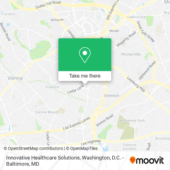
See Innovative Healthcare Solutions, Fairfax County, on the map
Public Transit to Innovative Healthcare Solutions in Fairfax County
Wondering how to get to Innovative Healthcare Solutions in Fairfax County? Moovit helps you find the best way to get to Innovative Healthcare Solutions with step-by-step directions from the nearest public transit station.
Moovit provides free maps and live directions to help you navigate through your city. View schedules, routes, timetables, and find out how long does it take to get to Innovative Healthcare Solutions in real time.
Looking for the nearest stop or station to Innovative Healthcare Solutions? Check out this list of stops closest to your destination: Gallows Rd @ Oak St; Electric Ave @ Central Ave; Dunn Loring Merrifield Metro Station; Mclean.
Bus: 401, 402, 462.Metro: ORANGE, SILVER.
Want to see if there’s another route that gets you there at an earlier time? Moovit helps you find alternative routes or times. Get directions from and directions to Innovative Healthcare Solutions easily from the Moovit App or Website.
We make riding to Innovative Healthcare Solutions easy, which is why over 1.5 million users, including users in Fairfax County, trust Moovit as the best app for public transit. You don’t need to download an individual bus app or train app, Moovit is your all-in-one transit app that helps you find the best bus time or train time available.
For information on prices of bus and metro, costs and ride fares to Innovative Healthcare Solutions, please check the Moovit app.
Use the app to navigate to popular places including to the airport, hospital, stadium, grocery store, mall, coffee shop, school, college, and university.
Innovative Healthcare Solutions Address: 2235 Cedar Ln Vienna, VA 22182 street in Fairfax County
- CSS East,
- Med-Strategies,
- US department of state sa 11,
- Diplomatic Security Training Center (DSTC),
- Vision Latina,
- Iranian-American Community Center,
- WESTERN UNION,
- Credit Union 1,
- Isap Office,
- Assakkaf Establishment,
- Dunn,
- Cici Spa,
- Jin Wellness Center LL,
- Internet Data Exchange,
- Tysons Corner Office,
- David Olenzak Holdings,
- Jil Tysons,
- The Islamic Heritage Center,
- Dunn Loring Volunteer Fire and Rescue Department,
- Dunn Loring, Virginia
Places Near Innovative Healthcare Solutions (Fairfax County)
- National Mall, Washington,
- Capital One Arena, Washington,
- Marriott Marquis Washington, DC, Washington,
- Westfield Montgomery Mall, Montgomery County,
- Basilica of the National Shrine, Washington,
- Rock Creek Tennis Center, Washington,
- Warner Theatre, Washington,
- Museum Of The Bible, Washington,
- Pennsylvania Ave NW (3rd st and pennsylvania), Washington,
- National Museum of African American History and Culture, Washington,
- Amazon Hq2, Arlington County,
- National Zoo, Washington,
- Camden Yards, Baltimore,
- Washington National Cathedral, Washington,
- PG Mall, Prince George's County,
- Washington DC VA Medical Center, Washington,
- Sibley Memorial Hospital, Washington,
- The Anthem, Washington,
- M&T Bank Stadium, Baltimore,
- Georgetown, Washington
How to get to popular places in Washington, D.C. - Baltimore, MD with public transit
Get around Fairfax County by public transit!
Traveling around Fairfax County has never been so easy. See step by step directions as you travel to any attraction, street or major public transit station. View bus and train schedules, arrival times, service alerts and detailed routes on a map, so you know exactly how to get to anywhere in Fairfax County.
When traveling to any destination around Fairfax County use Moovit's Live Directions with Get Off Notifications to know exactly where and how far to walk, how long to wait for your line, and how many stops are left. Moovit will alert you when it's time to get off — no need to constantly re-check whether yours is the next stop.
Wondering how to use public transit in Fairfax County or how to pay for public transit in Fairfax County? Moovit public transit app can help you navigate your way with public transit easily, and at minimum cost. It includes public transit fees, ticket prices, and costs. Looking for a map of Fairfax County public transit lines? Moovit public transit app shows all public transit maps in Fairfax County with all Bus, Train, Metro, Light Rail and Ferry routes and stops on an interactive map.
Washington, D.C. - Baltimore, MD has 5 transit type(s), including: Bus, Train, Metro, Light Rail and Ferry, operated by several transit agencies, including WMATA, Montgomery County Ride On, Fairfax Connector, TheBus, PRTC, DASH - Alexandria, Arlington Transit (ART), RTA of Central Maryland, MDOT MTA, MDOT MTA Light RailLink, MDOT MTA Commuter Bus, MDOT MTA Local Bus, FXBGO!, Virginia Railway Express (VRE) and MARC