Irvine Center-Research stop - Wednesday schedule
| Line | Direction | Time |
|---|---|---|
| 90 | Tustin Metrolink Station | 6:06 AM |
| 90 | Tustin Metrolink Station | 6:36 AM |
| 90 | Tustin Metrolink Station | 7:07 AM |
| 90 | Tustin Metrolink Station | 7:32 AM |
| 90 | Tustin Metrolink Station | 8:10 AM |
| 90 | Tustin Metrolink Station | 8:36 AM |
| 90 | Tustin Metrolink Station | 9:06 AM |
| 90 | Tustin Metrolink Station | 9:36 AM |
| 90 | Tustin Metrolink Station | 10:05 AM |
| 90 | Tustin Metrolink Station | 10:47 AM |
| 90 | Tustin Metrolink Station | 11:30 AM |
| 90 | Tustin Metrolink Station | 12:15 PM |
| 90 | Tustin Metrolink Station | 12:51 PM |
| 90 | Tustin Metrolink Station | 1:42 PM |
| 90 | Tustin Metrolink Station | 2:21 PM |
| 90 | Tustin Metrolink Station | 3:07 PM |
| 90 | Tustin Metrolink Station | 3:45 PM |
| 90 | Tustin Metrolink Station | 4:19 PM |
| 90 | Tustin Metrolink Station | 4:49 PM |
| 90 | Tustin Metrolink Station | 5:19 PM |
| 90 | Tustin Metrolink Station | 5:49 PM |
| 90 | Tustin Metrolink Station | 6:29 PM |
| 90 | Tustin Metrolink Station | 7:08 PM |
| 90 | Tustin Metrolink Station | 7:53 PM |
| 90 | Tustin Metrolink Station | 8:38 PM |
Directions to Irvine Center-Research stop with public transit
The following transit lines have routes that pass near Irvine Center-Research
 Bus: 90, 480.
- Train: IE-OC LINE, OC LINE, PACIFIC SURFLINER.
How to get to Irvine Center-Research stop by bus?
Click on the bus route to see step by step directions with maps, line arrival times and updated time schedules.
Bus stops near Irvine Center-Research stop
- Irvine Center-Antivo, 2 min walk,
- Technology-Ent 19 Technology, 35 min walk,
Train stations near Irvine Center-Research station
- Irvine Station, 39 min walk,
Bus lines to Irvine Center-Research stop
- 90, Dana Point Harbor,
- 480, Irvine Station,
What are the closest stations to Irvine Center-Research?
The closest stations to Irvine Center-Research are:
- Irvine Center-Antivo is 148 yards away, 2 min walk.
- Technology-Ent 19 Technology is 3012 yards away, 35 min walk.
- Irvine Station is 3292 yards away, 39 min walk.
Which bus line stops near Irvine Center-Research?
90 (Tustin Metrolink Station)
What’s the nearest bus station to Irvine Center-Research?
The nearest bus station to Irvine Center-Research is Irvine Center-Antivo. It’s a 2 min walk away.
What time is the first train to Irvine Center-Research?
The OC LINE is the first train that goes to Irvine Center-Research. It stops nearby at 5:12 AM.
What time is the last train to Irvine Center-Research?
The PACIFIC SURFLINER is the last train that goes to Irvine Center-Research. It stops nearby at 11:12 PM.
What time is the first bus to Irvine Center-Research?
The 90 is the first bus that goes to Irvine Center-Research. It stops nearby at 5:16 AM.
What time is the last bus to Irvine Center-Research?
The 90 is the last bus that goes to Irvine Center-Research. It stops nearby at 10:01 PM.
Irvine Center-Research station
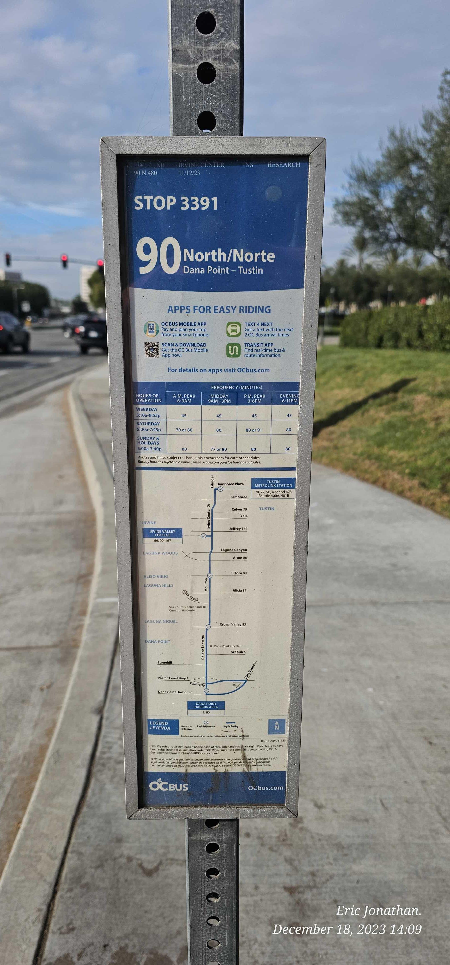 Taken by Anonymous
See Irvine Center-Research stop on the map
Public transit to Irvine Center-Research stop (ID: 3391)
Looking for directions to Irvine Center-Research in Irvine, United States?
Download the Moovit App to find the current schedule and step-by-step directions for Bus routes that pass through Irvine Center-Research.
Looking for the nearest stops closest to Irvine Center-Research ? Check out this list of closest stops to your destination: Irvine Center-Antivo; Technology-Ent 19 Technology; Irvine Station.
Bus: 90, 480.Train: IE-OC LINE, OC LINE, PACIFIC SURFLINER.
We make riding on public transit to Irvine Center-Research easy, which is why over 1.5 million users, including users in Irvine trust Moovit as the best app for public transit.
Use the app to navigate to popular places including to the airport, hospital, stadium, grocery store, mall, coffee shop, school, college, and university.
Irvine Center-Research stop’s code is 3391
The first line to this stop is 90, at 6:06 AM, and the last line is 90 at 9:59 PM.
8693 Irvine Center Dr, Irvine, CA, USA
This stop serves OCTA’s lines
- Irvine Center-Antivo,
- Technology-Ent 19 Technology
Bus stops near Irvine Center-Research stop
- Irvine Station
Train station near Irvine Center-Research station
- Sherman Way / Balboa,
- Van Nuys / Laurel Canyon,
- Vernon Station,
- Santa Monica / Westwood,
- UCLA Hilgard Terminal,
- Spring & Palo Verde NW,
- Rosecrans Ave & Inglewood Ave,
- Figueroa / Pacific Coast Highway,
- LA Brea & Beverly,
- Euclid-Commonwealth,
- Cherry & Broadway SW,
- Foothill at LA Canada Plaza,
- Imperial / Atlantic,
- Van Ness / Slauson,
- Manchester / Crenshaw,
- Atlantic / Whittier,
- Pch & Magnolia NW,
- San Fernando / Branford,
- Florence / Hooper,
- Imperial Hwy & Main St (Westbound)
Popular public transit stations in Irvine
Get around Irvine by public transit!
Traveling around Irvine has never been so easy. See step by step directions as you travel to any attraction, street or major public transit station. View bus and train schedules, arrival times, service alerts and detailed routes on a map, so you know exactly how to get to anywhere in Irvine.
When traveling to any destination around Irvine use Moovit's Live Directions with Get Off Notifications to know exactly where and how far to walk, how long to wait for your line, and how many stops are left. Moovit will alert you when it's time to get off — no need to constantly re-check whether yours is the next stop.
Wondering how to use public transit in Irvine or how to pay for public transit in Irvine? Moovit public transit app can help you navigate your way with public transit easily, and at minimum cost. It includes public transit fees, ticket prices, and costs. Looking for a map of Irvine public transit lines? Moovit public transit app shows all public transit maps in Irvine with all Bus, Train, Subway, Ferry and Funicular routes and stops on an interactive map.
Los Angeles has 5 transit type(s), including: Bus, Train, Subway, Ferry and Funicular, operated by several transit agencies, including Metro, Alhambra Community Transit, Arcadia Transit, Artesia Transit, AVTA, Baldwin Park Transit, Beach Cities Transit, Beaumont Transit, Bell Gardens Town Trolley, Bellflower Bus, Big Blue Bus, Burbank Bus, Calabasas Trolley, Camarillo Area Transit and Carson Circuit