Directions to Kelli Sells Re (Chesapeake) with public transportation
The following transit lines have routes that pass near Kelli Sells Re
 Bus: 047.
How to get to Kelli Sells Re by bus?
Click on the bus route to see step by step directions with maps, line arrival times and updated time schedules.
Bus stop near Kelli Sells Re in Chesapeake
- Churchland & Poplar Hill, 13 min walk,VIEW
Bus lines to Kelli Sells Re in Chesapeake
- 047, College & Lake View,VIEW
What are the closest stations to Kelli Sells Re?
The closest stations to Kelli Sells Re are:
- Churchland & Poplar Hill is 1036 yards away, 13 min walk.
Which bus line stops near Kelli Sells Re?
047 (College & Lake View)
What’s the nearest bus station to Kelli Sells Re in Chesapeake?
The nearest bus station to Kelli Sells Re in Chesapeake is Churchland & Poplar Hill. It’s a 13 min walk away.
What time is the first bus to Kelli Sells Re in Chesapeake?
The 047 is the first bus that goes to Kelli Sells Re in Chesapeake. It stops nearby at 5:50 AM.
What time is the last bus to Kelli Sells Re in Chesapeake?
The 047 is the last bus that goes to Kelli Sells Re in Chesapeake. It stops nearby at 10:01 PM.
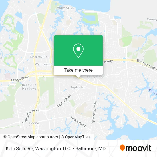
See Kelli Sells Re, Chesapeake, on the map
Public Transit to Kelli Sells Re in Chesapeake
Wondering how to get to Kelli Sells Re in Chesapeake? Moovit helps you find the best way to get to Kelli Sells Re with step-by-step directions from the nearest public transit station.
Moovit provides free maps and live directions to help you navigate through your city. View schedules, routes, timetables, and find out how long does it take to get to Kelli Sells Re in real time.
Looking for the nearest stop or station to Kelli Sells Re? Check out this list of stops closest to your destination: Churchland & Poplar Hill.
Bus: 047.
Want to see if there’s another route that gets you there at an earlier time? Moovit helps you find alternative routes or times. Get directions from and directions to Kelli Sells Re easily from the Moovit App or Website.
We make riding to Kelli Sells Re easy, which is why over 1.5 million users, including users in Chesapeake, trust Moovit as the best app for public transit. You don’t need to download an individual bus app or train app, Moovit is your all-in-one transit app that helps you find the best bus time or train time available.
For information on prices of bus, costs and ride fares to Kelli Sells Re, please check the Moovit app.
Use the app to navigate to popular places including to the airport, hospital, stadium, grocery store, mall, coffee shop, school, college, and university.
Kelli Sells Re Address: 3237 Western Branch Blvd Chesapeake, VA 23321 street in Chesapeake
- DOT Bledsoe - William E. Wood,
- Danielle Sticha - Howard Hanna Real Estate Services,
- Tiffany Butler, Realtor,
- Gwyneth Griffith with Towne Mortgage,
- Monica Moreland, Realtor,
- William E Wood Realty,
- Studios & Suites 4 Less,
- Hampton Inn,
- Aronold Jeffrey Weisberg,
- Eastern Virginia Family & Cosmetic Dentistry,
- Benzie Realty,
- Total Cleaning of VA,
- Best Western Plus Portsmouth Chesapeake Hotel,
- Leadership Training International,
- Hair by Andrea,
- Servicemaster Clean,
- Thomas J. Ishom,
- Three Rivers Midwifery Service,
- Stepping Stone's Counseling Services,
- Orange Julius
Places Near Kelli Sells Re (Chesapeake)
- Warner Theatre, Washington,
- M&T Bank Stadium, Baltimore,
- Museum Of The Bible, Washington,
- National Museum of African American History and Culture, Washington,
- Rock Creek Tennis Center, Washington,
- PG Mall, Prince George's County,
- National Mall, Washington,
- The Anthem, Washington,
- Amazon Hq2, Arlington County,
- Washington National Cathedral, Washington,
- Washington DC VA Medical Center, Washington,
- Georgetown, Washington,
- Camden Yards, Baltimore,
- Marriott Marquis Washington, DC, Washington,
- National Zoo, Washington,
- Pennsylvania Ave NW (3rd st and pennsylvania), Washington,
- Sibley Memorial Hospital, Washington,
- Basilica of the National Shrine, Washington,
- Westfield Montgomery Mall, Montgomery County,
- Capital One Arena, Washington
How to get to popular places in Washington, D.C. - Baltimore, MD with public transit
Get around Chesapeake by public transit!
Traveling around Chesapeake has never been so easy. See step by step directions as you travel to any attraction, street or major public transit station. View bus and train schedules, arrival times, service alerts and detailed routes on a map, so you know exactly how to get to anywhere in Chesapeake.
When traveling to any destination around Chesapeake use Moovit's Live Directions with Get Off Notifications to know exactly where and how far to walk, how long to wait for your line, and how many stops are left. Moovit will alert you when it's time to get off — no need to constantly re-check whether yours is the next stop.
Wondering how to use public transit in Chesapeake or how to pay for public transit in Chesapeake? Moovit public transit app can help you navigate your way with public transit easily, and at minimum cost. It includes public transit fees, ticket prices, and costs. Looking for a map of Chesapeake public transit lines? Moovit public transit app shows all public transit maps in Chesapeake with all Bus, Train, Metro, Light Rail and Ferry routes and stops on an interactive map.
Washington, D.C. - Baltimore, MD has 5 transit type(s), including: Bus, Train, Metro, Light Rail and Ferry, operated by several transit agencies, including WMATA, Montgomery County Ride On, Fairfax Connector, TheBus, PRTC, DASH - Alexandria, Arlington Transit (ART), RTA of Central Maryland, MDOT MTA, MDOT MTA Light RailLink, MDOT MTA Commuter Bus, MDOT MTA Local Bus, FXBGO!, Virginia Railway Express (VRE) and MARC