Kipling Go station - Thursday schedule
| Line | Direction | Time |
|---|---|---|
| KI | Eastbound | 6:42 AM |
| KI | Eastbound | 7:12 AM |
| KI | Eastbound | 7:27 AM |
| KI | Eastbound | 7:42 AM |
| KI | Eastbound | 7:57 AM |
| KI | Eastbound | 8:12 AM |
| KI | Eastbound | 8:27 AM |
| KI | Eastbound | 8:42 AM |
| KI | Eastbound | 8:57 AM |
| KI | Eastbound | 9:12 AM |
| KI | Westbound | 3:58 PM |
| KI | Westbound | 4:28 PM |
| KI | Westbound | 4:43 PM |
| KI | Westbound | 4:58 PM |
| KI | Westbound | 5:13 PM |
| KI | Westbound | 5:28 PM |
| KI | Westbound | 5:43 PM |
| KI | Westbound | 6:13 PM |
| KI | Westbound | 6:43 PM |
| KI | Westbound | 7:28 PM |
Directions to Kipling Go station (Toronto) with public transit
The following transit lines have routes that pass near Kipling Go
How to get to Kipling Go station by bus?
Click on the bus route to see step by step directions with maps, line arrival times and updated time schedules.
How to get to Kipling Go station by train?
Click on the train route to see step by step directions with maps, line arrival times and updated time schedules.
How to get to Kipling Go station by subway?
Click on the subway route to see step by step directions with maps, line arrival times and updated time schedules.
Bus stops near Kipling Go stop in Toronto
- Kipling Terminal Platform 3, 1 min walk,
- Kipling Terminal Platform 4, 1 min walk,
- Kipling Terminal Platform 6, 2 min walk,
- Kipling Terminal Platform 5, 2 min walk,
- Kipling Terminal Platform 13, 3 min walk,
- Kipling Bus Terminal, 3 min walk,
- Kipling Terminal Platform 12, 3 min walk,
- Kipling Station, 3 min walk,
- Dundas St At Acorn Ave, 4 min walk,
- Kipling Terminal Platform 14, 4 min walk,
Subway stations near Kipling Go station in Toronto
- Kipling, 2 min walk,
Bus lines to Kipling Go station in Toronto
- 35, 35 E Eglinton To Kipling Terminal,
- 101, 101a E Express Dundas Exp,
- 70, 70 W Keaton To Milverton,
- 71, 71 E Sheridan To Kipling Terminal,
- 108, 108 N Express Financial Exp,
- 307, 307 W Philip Pocock SS To School,
- 11, 11 S Westwood To Kipling Terminal,
- 126, 126 E Express Burnhamthorpe Exp,
- 29, 29 - Kipling Bus Terminal,
- 20, 20 W Rathburn To City Centre,
- 111, Kipling Station,
- 112, Kipling Station,
- 112B, Renforth Station,
- 112C, International Blvd at Carlingview Dr East Side,
- 123B, Long Branch Loop,
- 123C, Kipling Station,
- 123D, Kipling Station,
- 123F, Kipling Station,
- 1, 1 W Dundas To Ridgeway,
- 3, 3 W Bloor To City Centre,
What are the closest stations to Kipling Go?
The closest stations to Kipling Go are:
- Kipling Terminal Platform 3 is 29 meters away, 1 min walk.
- Kipling Terminal Platform 4 is 67 meters away, 1 min walk.
- Kipling Terminal Platform 6 is 87 meters away, 2 min walk.
- Kipling Terminal Platform 5 is 95 meters away, 2 min walk.
- Kipling is 149 meters away, 2 min walk.
- Kipling Terminal Platform 13 is 153 meters away, 3 min walk.
- Kipling Bus Terminal is 161 meters away, 3 min walk.
- Kipling Terminal Platform 12 is 166 meters away, 3 min walk.
- Kipling Station is 199 meters away, 3 min walk.
- Dundas St At Acorn Ave is 238 meters away, 4 min walk.
- Kipling Terminal Platform 14 is 240 meters away, 4 min walk.
Which bus lines stop near Kipling Go?
These bus lines stop near Kipling Go: 109, 123C, 40A, 44.
Which train line stops near Kipling Go?
MI (Milton)
Which subway line stops near Kipling Go?
2 (Towards Kipling)
What’s the nearest subway station to Kipling Go in Toronto?
The nearest subway station to Kipling Go in Toronto is Kipling. It’s a 2 min walk away.
What’s the nearest bus station to Kipling Go in Toronto?
The nearest bus stations to Kipling Go in Toronto are Kipling Terminal Platform 3 and Kipling Terminal Platform 4. The closest one is a 1 min walk away.
What time is the first subway to Kipling Go in Toronto?
The 2 is the first subway that goes to Kipling Go in Toronto. It stops nearby at 5:40 AM.
What time is the last subway to Kipling Go in Toronto?
The 2 is the last subway that goes to Kipling Go in Toronto. It stops nearby at 2:16 AM.
What time is the first bus to Kipling Go in Toronto?
The 1 is the first bus that goes to Kipling Go in Toronto. It stops nearby at 3:00 AM.
What time is the last bus to Kipling Go in Toronto?
The 11 is the last bus that goes to Kipling Go in Toronto. It stops nearby at 3:02 AM.
See Kipling Go station, Toronto, on the map
Public transit to Kipling Go station in Toronto
Looking for directions to Kipling Go in Toronto, Canada?
Download the Moovit App to find the current schedule and step-by-step directions for Bus, Subway, Streetcar or Train routes that pass through Kipling Go.
Looking for the nearest stops closest to Kipling Go ? Check out this list of closest stops to your destination: Kipling Terminal Platform 3; Kipling Terminal Platform 4; Kipling Terminal Platform 6; Kipling Terminal Platform 5; Kipling; Kipling Terminal Platform 13; Kipling Bus Terminal; Kipling Terminal Platform 12; Kipling Station; Dundas St At Acorn Ave; Kipling Terminal Platform 14.
Bus: 109, 123C, 40A, 44, 35, 101, 70, 71, 108, 307, 11, 126.Train: MI.Subway: 2.
We make riding on public transit to Kipling Go easy, which is why over 1.5 million users, including users in Toronto trust Moovit as the best app for public transit.
Use the app to navigate to popular places including to the airport, hospital, stadium, grocery store, mall, coffee shop, school, college, and university.
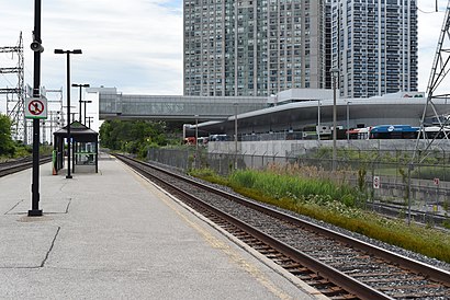
The station has the following entrances: Kipling Go-Subway Cres and Saint Albans Road 27
The first line to this station is KI, at 6:42 AM, and the last line is KI at 7:28 PM.
Passenger Pick-Up/Drop-Off, Toronto, ON, Canada
This station serves GO Transit’s lines
Popular routes from Kipling Go station, Toronto
Bus stops near Kipling Go stop
Subway station near Kipling Go station
Popular public transit stations in Toronto
Get around Toronto by public transit!
Traveling around Toronto has never been so easy. See step by step directions as you travel to any attraction, street or major public transit station. View bus and train schedules, arrival times, service alerts and detailed routes on a map, so you know exactly how to get to anywhere in Toronto.
When traveling to any destination around Toronto use Moovit's Live Directions with Get Off Notifications to know exactly where and how far to walk, how long to wait for your line, and how many stops are left. Moovit will alert you when it's time to get off — no need to constantly re-check whether yours is the next stop.
Wondering how to use public transit in Toronto or how to pay for public transit in Toronto? Moovit public transit app can help you navigate your way with public transit easily, and at minimum cost. It includes public transit fees, ticket prices, and costs. Looking for a map of Toronto public transit lines? Moovit public transit app shows all public transit maps in Toronto with all Bus, Train, Subway, Streetcar and Ferry routes and stops on an interactive map.
Toronto has 5 transit type(s), including: Bus, Train, Subway, Streetcar and Ferry, operated by several transit agencies, including TTC, TTC Streetcar, Toronto Subway, Brampton Transit, MiWay, York Region Transit, GO Transit Bus, GO Transit, Durham Region Transit, UP Express, Grand River Transit, Guelph Transit, Hamilton Street Railway, Burlington Transit and Oakville Transit