Knights Rd & Academy Rd - FS stop - Tuesday schedule
| Line | Direction | Time |
|---|---|---|
| 84 | Frankford Transit Center | 5:27 AM |
| 84 | Frankford Transit Center | 5:52 AM |
| 67 | Frankford Transit Center | 6:13 AM |
| 84 | Frankford Transit Center | 6:17 AM |
| 67 | Frankford Transit Center | 6:38 AM |
| 84 | Frankford Transit Center | 6:39 AM |
| 67 | Frankford Transit Center | 6:56 AM |
| 84 | Frankford Transit Center | 6:57 AM |
| 84 | Frankford Transit Center | 7:17 AM |
| 84 | Frankford Transit Center | 7:37 AM |
| 67 | Frankford Transit Center | 7:38 AM |
| 84 | Frankford Transit Center | 7:57 AM |
| 84 | Frankford Transit Center | 8:17 AM |
| 84 | Frankford Transit Center | 8:37 AM |
| 67 | Frankford Transit Center | 8:41 AM |
| 84 | Frankford Transit Center | 8:57 AM |
| 84 | Frankford Transit Center | 9:17 AM |
| 67 | Frankford Transit Center | 9:39 AM |
| 84 | Frankford Transit Center | 9:41 AM |
| 84 | Frankford Transit Center | 10:11 AM |
| 67 | Frankford Transit Center | 10:40 AM |
| 84 | Frankford Transit Center | 10:41 AM |
| 84 | Frankford Transit Center | 11:11 AM |
| 67 | Frankford Transit Center | 11:38 AM |
| 84 | Frankford Transit Center | 11:41 AM |
Directions to Knights Rd & Academy Rd - FS stop (Philadelphia) with public transit
The following transit lines have routes that pass near Knights Rd & Academy Rd - FS
 Bus: 20, 50, 67, 84, 129.
- Train: TRE.
- Cable Car: 66.
How to get to Knights Rd & Academy Rd - FS stop by bus?
Click on the bus route to see step by step directions with maps, line arrival times and updated time schedules.
Bus stops near Knights Rd & Academy Rd - FS stop in Philadelphia
- Knights Rd & Franklin Mill Blvd, 1 min walk,
- Franklin Mills Dr & Knights Rd, 2 min walk,
- Franklin Mills & Design Center Dr, 2 min walk,
Train stations near Knights Rd & Academy Rd - FS station in Philadelphia
- Eddington, 28 min walk,
Cable Car stations near Knights Rd & Academy Rd - FS station in Philadelphia
- Frankford Av & Lyman Dr - Fs, 48 min walk,
Bus lines to Knights Rd & Academy Rd - FS stop in Philadelphia
- 67, Philadelphia Mills Via Industrial,
- 84, Philadelphia Mills,
- 50, Frankford Transit Center,
- 129, Bridgewater Industrial Park,
- 130, Neshaminy Mall,
- 20, Philadelphia Mills,
What are the closest stations to Knights Rd & Academy Rd - FS?
The closest stations to Knights Rd & Academy Rd - FS are:
- Knights Rd & Franklin Mill Blvd stop is 73 yards away, 1 min walk.
- Franklin Mills Dr & Knights Rd stop is 79 yards away, 2 min walk.
- Franklin Mills & Design Center Dr stop is 165 yards away, 2 min walk.
- Eddington station is 2379 yards away, 28 min walk.
- Frankford Av & Lyman Dr - Fs station is 4110 yards away, 48 min walk.
Which bus lines stop near Knights Rd & Academy Rd - FS?
These bus lines stop near Knights Rd & Academy Rd - FS: 20, 50, 67, 84.
What’s the nearest train station to Knights Rd & Academy Rd - FS in Philadelphia?
The nearest train station to Knights Rd & Academy Rd - FS in Philadelphia is Eddington. It’s a 28 min walk away.
What’s the nearest bus station to Knights Rd & Academy Rd - FS in Philadelphia?
The nearest bus station to Knights Rd & Academy Rd - FS in Philadelphia is Knights Rd & Franklin Mill Blvd. It’s a 1 min walk away.
Knights Rd & Academy Rd - FS station
 Taken by Anonymous
See Knights Rd & Academy Rd - FS stop, Philadelphia, on the map
Public transit to Knights Rd & Academy Rd - FS stop (ID: 1100) in Philadelphia
Looking for directions to Knights Rd & Academy Rd - FS in Philadelphia, United States?
Download the Moovit App to find the current schedule and step-by-step directions for Bus, Light Rail or Train routes that pass through Knights Rd & Academy Rd - FS.
Looking for the nearest stops closest to Knights Rd & Academy Rd - FS ? Check out this list of closest stops to your destination: Knights Rd & Franklin Mill Blvd; Franklin Mills Dr & Knights Rd; Franklin Mills & Design Center Dr; Eddington; Frankford Av & Lyman Dr - Fs.
Bus: 20, 50, 67, 84, 129, 130.Train: TRE.Cable Car: 66.
We make riding on public transit to Knights Rd & Academy Rd - FS easy, which is why over 1.7 billion users, including users in Philadelphia trust Moovit as the best app for public transit.
Use the app to navigate to popular places including to the airport, hospital, stadium, grocery store, mall, coffee shop, school, college, and university.
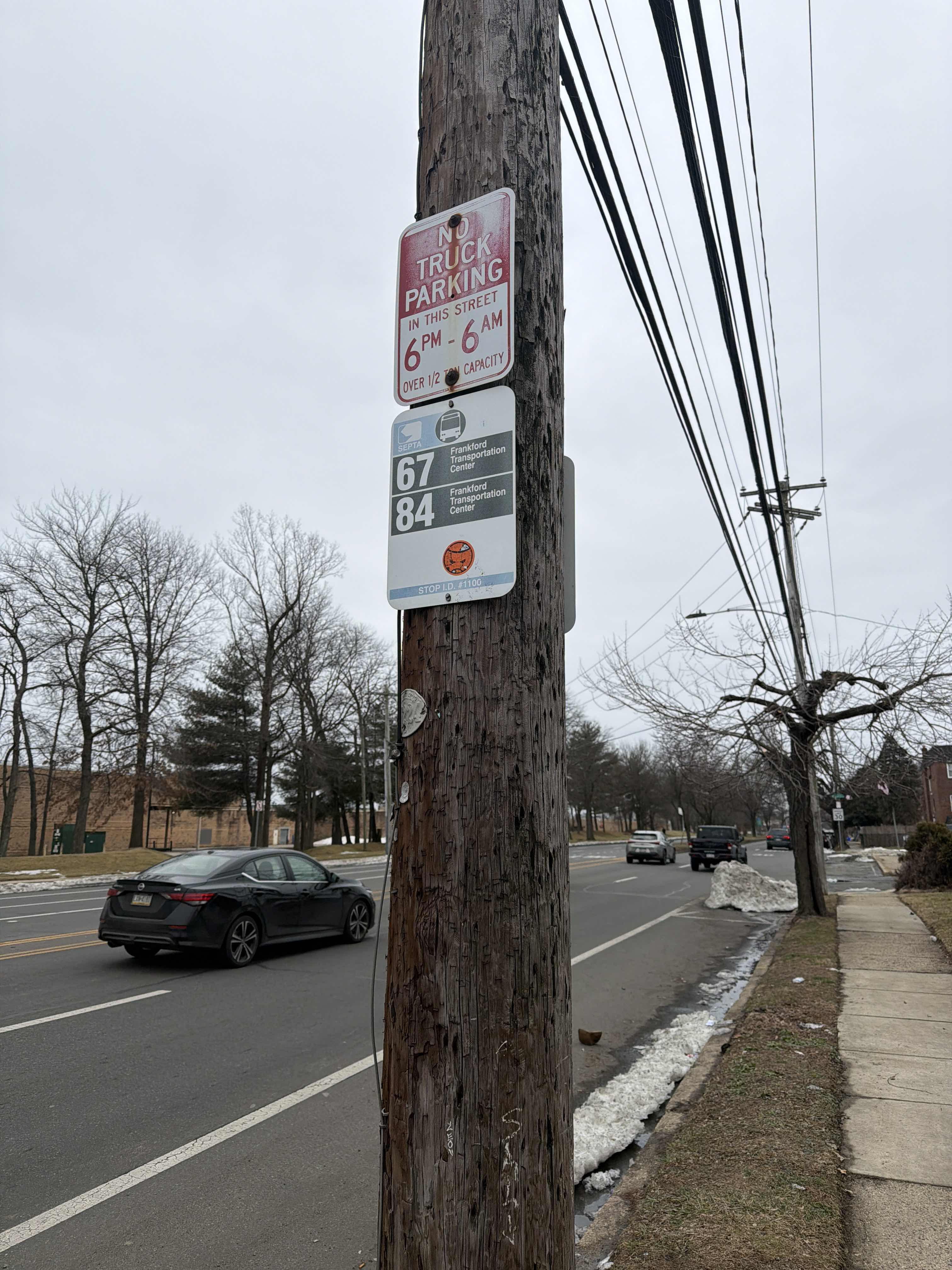
Knights Rd & Academy Rd - FS stop’s code is 1100
The first line to this stop is 84, at 5:27 AM, and the last line is 84 at 12:49 AM.
3738 Academy Rd, Philadelphia, PA, USA
This stop serves SEPTA’s lines
- Knights Rd & Franklin Mill Blvd,
- Franklin Mills Dr & Knights Rd,
- Franklin Mills & Design Center Dr
Bus stops near Knights Rd & Academy Rd - FS stop
- Eddington
Train station near Knights Rd & Academy Rd - FS station
- Frankford Av & Lyman Dr - Fs
Cable Car station near Knights Rd & Academy Rd - FS station
- Broad St & Jefferson St,
- Bustleton Av & Cottman Av ,
- Hunting Park Av & 19th St,
- 17th St & Montgomery Av,
- Roosevelt Blvd & Haldeman Av,
- University Av & Curie Blvd,
- Germantown Av & Windrim Av,
- 17th St & Callowhill St ,
- Broad St & Tioga St,
- 17th St & Spring Garden St,
- Tacony,
- 34th St & Market St - Fs,
- Richmond St & Orthodox St,
- Ben Franklin Pkwy & 22nd St,
- Egypt Rd & Mill Rd,
- 7th St & Berks St ,
- 4th St & Bainbridge St,
- Radcliffe St & Monroe St,
- 17th St & Diamond St ,
- Pottstown Pk & Us 30
Popular public transit stations in Philadelphia
Get around Philadelphia by public transit!
Traveling around Philadelphia has never been so easy. See step by step directions as you travel to any attraction, street or major public transit station. View bus and train schedules, arrival times, service alerts and detailed routes on a map, so you know exactly how to get to anywhere in Philadelphia.
When traveling to any destination around Philadelphia use Moovit's Live Directions with Get Off Notifications to know exactly where and how far to walk, how long to wait for your line, and how many stops are left. Moovit will alert you when it's time to get off — no need to constantly re-check whether yours is the next stop.
Wondering how to use public transit in Philadelphia or how to pay for public transit in Philadelphia? Moovit public transit app can help you navigate your way with public transit easily, and at minimum cost. It includes public transit fees, ticket prices, and costs. Looking for a map of Philadelphia public transit lines? Moovit public transit app shows all public transit maps in Philadelphia with all Bus, Train, Metro, Light Rail and Cable Car routes and stops on an interactive map.
Philadelphia has 5 transit type(s), including: Bus, Train, Metro, Light Rail and Cable Car, operated by several transit agencies, including SEPTA Subway, SEPTA Rail, SEPTA, SEPTA Trolley, NJ Transit Rail, NJ Transit, Port Authority Transit Corporation, Navy Yard, Penn Transit, Drexel University, Pottstown Area Rapid Transit (PART), Fullington Tours, Chescobus, Amtrak and Greyhound-us