Larchmont Av+Fable St stop - Saturday schedule
| Line | Direction | Time |
|---|---|---|
| P63 | East To Largo | 7:23 AM |
| P63 | East To Largo | 8:23 AM |
| P63 | East To Largo | 9:23 AM |
| P63 | East To Largo | 10:23 AM |
| P63 | East To Largo | 11:23 AM |
| P63 | East To Largo | 12:24 PM |
| P63 | East To Largo | 1:24 PM |
| P63 | East To Largo | 2:24 PM |
| P63 | East To Largo | 3:24 PM |
| P63 | East To Largo | 4:23 PM |
| P63 | East To Largo | 5:23 PM |
| P63 | East To Largo | 6:23 PM |
| P63 | East To Largo | 7:23 PM |
| P63 | East To Largo | 8:23 PM |
| P63 | East To Largo | 9:23 PM |
Directions to Larchmont Av+Fable St stop (Prince George's County) with public transit
The following transit lines have routes that pass near Larchmont Av+Fable St
 Bus: P63, C37, P62.
- Metro: BLUE, SILVER, ORANGE, GREEN.
How to get to Larchmont Av+Fable St stop by bus?
Click on the bus route to see step by step directions with maps, line arrival times and updated time schedules.
How to get to Larchmont Av+Fable St stop by metro?
Click on the metro route to see step by step directions with maps, line arrival times and updated time schedules.
Bus stops near Larchmont Av+Fable St stop in Prince George's County
- Larchmont Av+Fable St, 1 min walk,
- Southern Av Se+Fable St SE, 9 min walk,
- Brooke Rd & Highview Pl, 20 min walk,
Metro stations near Larchmont Av+Fable St station in Prince George's County
- Minnesota Ave, 42 min walk,
- Benning Rd Metro Station, 47 min walk,
- Suitland Metro Station, 54 min walk,
Bus lines to Larchmont Av+Fable St stop in Prince George's County
- P63, East To Largo,
- C37, South To Potomac Av,
- P62, South To Branch Av,
What are the closest stations to Larchmont Av+Fable St?
The closest stations to Larchmont Av+Fable St are:
- Larchmont Av+Fable St stop is 25 yards away, 1 min walk.
- Southern Av Se+Fable St SE stop is 767 yards away, 9 min walk.
- Brooke Rd & Highview Pl stop is 1670 yards away, 20 min walk.
- Minnesota Ave station is 3583 yards away, 42 min walk.
- Benning Rd Metro Station is 4097 yards away, 47 min walk.
- Suitland Metro Station is 4672 yards away, 54 min walk.
Which bus line stops near Larchmont Av+Fable St?
P63 (West To Naylor Rd)
Which metro lines stop near Larchmont Av+Fable St?
These metro lines stop near Larchmont Av+Fable St: BLUE, SILVER.
What’s the nearest bus station to Larchmont Av+Fable St in Prince George's County?
The nearest bus station to Larchmont Av+Fable St in Prince George's County is Larchmont Av+Fable St. It’s a 1 min walk away.
What time is the first metro to Larchmont Av+Fable St in Prince George's County?
The BLUE is the first metro that goes to Larchmont Av+Fable St in Prince George's County. It stops nearby at 4:59 AM.
What time is the last metro to Larchmont Av+Fable St in Prince George's County?
The GREEN is the last metro that goes to Larchmont Av+Fable St in Prince George's County. It stops nearby at 12:35 AM.
What time is the first bus to Larchmont Av+Fable St in Prince George's County?
The C37 is the first bus that goes to Larchmont Av+Fable St in Prince George's County. It stops nearby at 4:47 AM.
What time is the last bus to Larchmont Av+Fable St in Prince George's County?
The C37 is the last bus that goes to Larchmont Av+Fable St in Prince George's County. It stops nearby at 2:14 AM.
Larchmont Av+Fable St station
 Taken by Keanna C.
See Larchmont Av+Fable St stop, Prince George's County, on the map
Public transit to Larchmont Av+Fable St stop (ID: 3000899) in Prince George's County
Looking for directions to Larchmont Av+Fable St in Prince George's County, United States?
Download the Moovit App to find the current schedule and step-by-step directions for Bus or Metro routes that pass through Larchmont Av+Fable St.
Looking for the nearest stops closest to Larchmont Av+Fable St ? Check out this list of closest stops to your destination: Larchmont Av+Fable St; Southern Av Se+Fable St SE; Brooke Rd & Highview Pl; Minnesota Ave; Benning Rd Metro Station; Suitland Metro Station.
Bus: P63, C37, P62.Metro: BLUE, SILVER, ORANGE, GREEN.
We make riding on public transit to Larchmont Av+Fable St easy, which is why over 1.7 billion users, including users in Prince George's County trust Moovit as the best app for public transit.
Use the app to navigate to popular places including to the airport, hospital, stadium, grocery store, mall, coffee shop, school, college, and university.
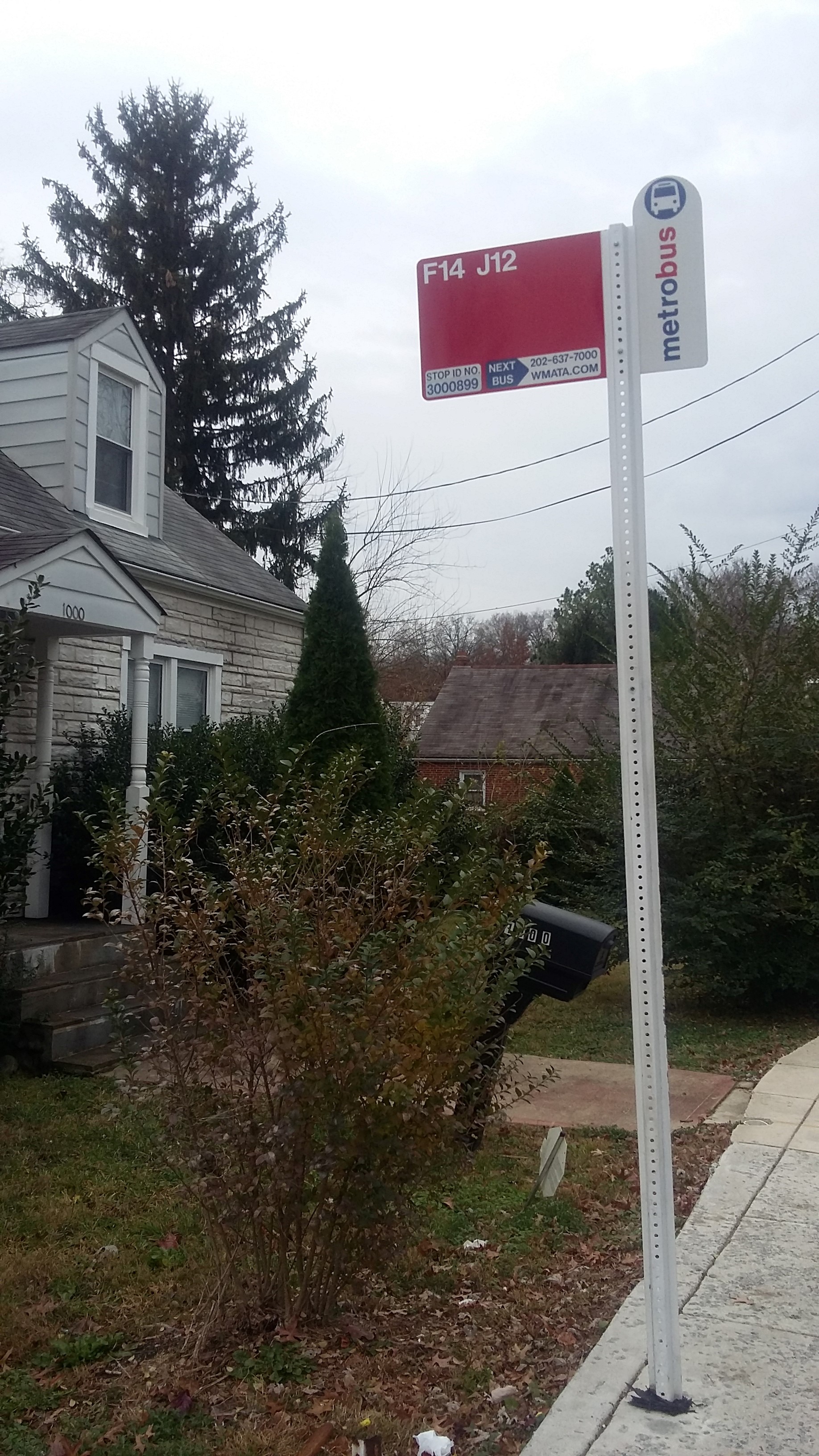
Larchmont Av+Fable St stop’s code is 3000899
The first line to this stop is P63, at 7:23 AM, and the last line is P63 at 9:23 PM.
This stop serves WMATA’s lines
- Larchmont Av+Fable St,
- Southern Av Se+Fable St SE,
- Brooke Rd & Highview Pl
Bus stops near Larchmont Av+Fable St stop
- Minnesota Ave,
- Benning Rd Metro Station,
- Suitland Metro Station
Metro stations near Larchmont Av+Fable St station
- 6 St Se+Southern Av SE,
- Wiehle Av @ North Shore Dr,
- Old Georgetown Rd & Cordell Ave,
- 11 St Nw+F St NW,
- Charlotte Hall Veterans Home,
- Medical Center Station & Bay E,
- Columbia Rd Nw+18 St NW,
- Georgia Av+Norbeck Rd,
- Reservoir Rd Nw+38 St NW,
- Randolph Rd & Dewey Rd,
- Bwi Thurgood Marshall Airport, Md,
- Nova Campus In Manassas Departures,
- Darnestown Rd & Shady Grove Rd,
- Georgia Av Nw+Decatur St NW,
- K St Nw & New Jersey Ave Nw,
- White Horse Apartments (Pulaski Hwy/Us 40),
- Johnson+Ml King Jr Hwy,
- Northside (On Pulaski Hwy/Us 40),
- Kilimanjaro Rd / Oakland Mills High School,
- Centreville Rd @ Mclearen Rd
Popular public transit stations in Prince George's County
Get around Prince George's County by public transit!
Traveling around Prince George's County has never been so easy. See step by step directions as you travel to any attraction, street or major public transit station. View bus and train schedules, arrival times, service alerts and detailed routes on a map, so you know exactly how to get to anywhere in Prince George's County.
When traveling to any destination around Prince George's County use Moovit's Live Directions with Get Off Notifications to know exactly where and how far to walk, how long to wait for your line, and how many stops are left. Moovit will alert you when it's time to get off — no need to constantly re-check whether yours is the next stop.
Wondering how to use public transit in Prince George's County or how to pay for public transit in Prince George's County? Moovit public transit app can help you navigate your way with public transit easily, and at minimum cost. It includes public transit fees, ticket prices, and costs. Looking for a map of Prince George's County public transit lines? Moovit public transit app shows all public transit maps in Prince George's County with all Bus, Train, Metro, Light Rail and Ferry routes and stops on an interactive map.
Washington, D.C. - Baltimore, MD has 5 transit type(s), including: Bus, Train, Metro, Light Rail and Ferry, operated by several transit agencies, including WMATA, Montgomery County Ride On, Fairfax Connector, Prince Georges County's TheBus, PRTC, DASH - Alexandria, Arlington Transit (ART), RTA of Central Maryland, MDOT MTA, MDOT MTA Light RailLink, MDOT MTA Commuter Bus, MDOT MTA Local Bus, FXBGO!, Virginia Railway Express (VRE) and MARC