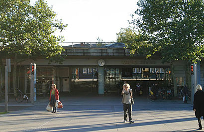
Lyngby St. station - Saturday schedule
| Line | Direction | Time |
|---|---|---|
| 920E | Hillerød | 4:02 AM |
| 920E | Hundested | 4:24 AM |
| 920E | Hillerød | 4:32 AM |
| 920E | Hundested | 4:54 AM |
| 920E | Hillerød | 5:02 AM |
| 920E | Hundested | 5:24 AM |
| 920E | Hillerød | 5:32 AM |
| 920E | Hundested | 5:54 AM |
| 920E | Hillerød | 6:02 AM |
| 920E | Hundested | 6:24 AM |
| 920E | Hillerød | 6:32 AM |
| 920E | Hillerød | 6:52 AM |
| 920E | Hundested | 6:54 AM |
| 920E | Hillerød | 7:12 AM |
| 920E | Hundested | 7:14 AM |
| 920E | Hillerød | 7:32 AM |
| 920E | Hundested | 7:34 AM |
| 920E | Hillerød | 7:52 AM |
| 920E | Hundested | 7:54 AM |
| 920E | Hillerød | 8:12 AM |
| 920E | Hundested | 8:14 AM |
| 920E | Hillerød | 8:32 AM |
| 920E | Hundested | 8:34 AM |
| 920E | Hillerød | 8:52 AM |
| 920E | Hundested | 8:54 AM |
Directions to Lyngby St. station (Lyngby-Taarbæk) with public transit
The following transit lines have routes that pass near Lyngby St.
 Bus: 184, 192, 300S, 68, 179.
- Train: A, 910, E.
How to get to Lyngby St. station by bus?
Click on the bus route to see step by step directions with maps, line arrival times and updated time schedules.
How to get to Lyngby St. station by train?
Click on the train route to see step by step directions with maps, line arrival times and updated time schedules.
Bus stops near Lyngby St. stop in Lyngby-Taarbæk
- Lyngby St. (Gammel Jernbanevej), 1 min walk,
- Lyngby St., 1 min walk,
Train stations near Lyngby St. station in Lyngby-Taarbæk
- Nørgaardsvej St., 9 min walk,
- Jægersborg St., 19 min walk,
Bus lines to Lyngby St. station in Lyngby-Taarbæk
- 68, Bella Center St. (Martha Christensens Vej) - Lyngby St. (Jernbanepladsen),
- 179, Lyngby St. - Skovshoved Strandvejen (Teglgårdsvej),
- 184, Vedbæk St. - Nørreport St. (Nørre Voldgade),
- 194, Teknikerbyen (Skodsborgvej) - Lyngby St. (Gammel Jernbanevej),
- 40E, Høje Taastrup St.,
- 191, Lyngby St.,
- 192, Hellerup St.,
- 300S, Lyngby St.,
- 400S, Høje Taastrup St.,
- 182, Lyngby St.,
- 183, Trongårdsvej,
- 388, Taarbæk Havn,
- 193, Vedbæk St.,
What are the closest stations to Lyngby St.?
The closest stations to Lyngby St. are:
- Lyngby St. (Gammel Jernbanevej) is 34 meters away, 1 min walk.
- Lyngby St. is 37 meters away, 1 min walk.
- Nørgaardsvej St. is 661 meters away, 9 min walk.
- Jægersborg St. is 1438 meters away, 19 min walk.
Which bus lines stop near Lyngby St.?
These bus lines stop near Lyngby St.: 184, 192, 300S, 68.
Which train line stops near Lyngby St.?
A (Mod nord)
What’s the nearest train station to Lyngby St. in Lyngby-Taarbæk?
The nearest train station to Lyngby St. in Lyngby-Taarbæk is Nørgaardsvej St.. It’s a 9 min walk away.
What’s the nearest bus station to Lyngby St. in Lyngby-Taarbæk?
The nearest bus stations to Lyngby St. in Lyngby-Taarbæk are Lyngby St. (Gammel Jernbanevej) and Lyngby St.. The closest one is a 1 min walk away.
What time is the first train to Lyngby St. in Lyngby-Taarbæk?
The A is the first train that goes to Lyngby St. in Lyngby-Taarbæk. It stops nearby at 3:04 AM.
What time is the last train to Lyngby St. in Lyngby-Taarbæk?
The A is the last train that goes to Lyngby St. in Lyngby-Taarbæk. It stops nearby at 1:06 AM.
What time is the first bus to Lyngby St. in Lyngby-Taarbæk?
The 400S is the first bus that goes to Lyngby St. in Lyngby-Taarbæk. It stops nearby at 3:21 AM.
What time is the last bus to Lyngby St. in Lyngby-Taarbæk?
The 184 is the last bus that goes to Lyngby St. in Lyngby-Taarbæk. It stops nearby at 2:58 AM.
See Lyngby St. station, Lyngby-Taarbæk, on the map
Public transit to Lyngby St. station in Lyngby-Taarbæk
Looking for directions to Lyngby St. in Lyngby-Taarbæk, Denmark?
Download the Moovit App to find the current schedule and step-by-step directions for Train, Bus or Metro routes that pass through Lyngby St..
Looking for the nearest stops closest to Lyngby St. ? Check out this list of closest stops to your destination: Lyngby St. (Gammel Jernbanevej); Lyngby St.; Nørgaardsvej St.; Jægersborg St..
Bus: 184, 192, 300S, 68, 179, 194, 40E, 191, 400S.Train: A, 910, E.
We make riding on public transit to Lyngby St. easy, which is why over 1.5 million users, including users in Lyngby-Taarbæk trust Moovit as the best app for public transit.
Use the app to navigate to popular places including to the airport, hospital, stadium, grocery store, mall, coffee shop, school, college, and university.
The station has the following entrances: Lyngby St. and Ulrikkenborg Pl.
The first line to this station is 920E, at 4:02 AM, and the last line is 920E at 3:54 AM.
Jernbanepladsen 39A, Copenhagen, Denmark
This station serves Lokaltog A/S and DSB S-tog’s lines
Popular routes from Lyngby St. station, Lyngby-Taarbæk
- Lyngby St. (Gammel Jernbanevej),
- Lyngby St.
Bus stops near Lyngby St. stop
- Nørgaardsvej St.,
- Jægersborg St.
Train stations near Lyngby St. station
- Riis Feriepark,
- Arnkilgade V Sygehuset,
- Tårnby St.,
- Grimstrupvej,
- Nygårdsvej (Vennemindevej),
- Gammelmosevej (Buddingevej),
- Agedrup (Odense Kommune),
- Spodsbjerg Færgehavn (Langeland Kommune),
- Femvejen (Bernstorffsvej),
- Bagsværd Svømmehal (Værebrovej),
- Billedskærervej (Odense Kommune),
- Egebjerg Bygade (Egebjergvej),
- Gasværksvej (Istedgade),
- Psykiatrisk Sygehus (Brønderslev),
- Nørrevangsskolen/Hadsundvej (Randers Kom),
- Hallandsparken (Hallands Boulevard),
- Tyren (Vandmanden / Aalbog),
- Lergravsparken St. (Metro),
- Spangsbro Tømmerupvej (Kåstrupvej),
- Brydes Allé (Peder Lykkes Vej)
Popular public transit stations in Lyngby-Taarbæk
Get around Lyngby-Taarbæk by public transit!
Traveling around Lyngby-Taarbæk has never been so easy. See step by step directions as you travel to any attraction, street or major public transit station. View bus and train schedules, arrival times, service alerts and detailed routes on a map, so you know exactly how to get to anywhere in Lyngby-Taarbæk.
When traveling to any destination around Lyngby-Taarbæk use Moovit's Live Directions with Get Off Notifications to know exactly where and how far to walk, how long to wait for your line, and how many stops are left. Moovit will alert you when it's time to get off — no need to constantly re-check whether yours is the next stop.
Wondering how to use public transit in Lyngby-Taarbæk or how to pay for public transit in Lyngby-Taarbæk? Moovit public transit app can help you navigate your way with public transit easily, and at minimum cost. It includes public transit fees, ticket prices, and costs. Looking for a map of Lyngby-Taarbæk public transit lines? Moovit public transit app shows all public transit maps in Lyngby-Taarbæk with all Bus, Train, Metro, Light Rail and Ferry routes and stops on an interactive map.
Denmark has 5 transit type(s), including: Bus, Train, Metro, Light Rail and Ferry, operated by several transit agencies, including Metroselskabet, DSB S-tog, Lokaltog A/S, Midttrafik, Odense Letbane, DSB, NT, GoCollective, Skånetrafiken, Movia, FYNBUS, Sydtrafik, Bornholms Trafik, Citybus and Ærø Kommune