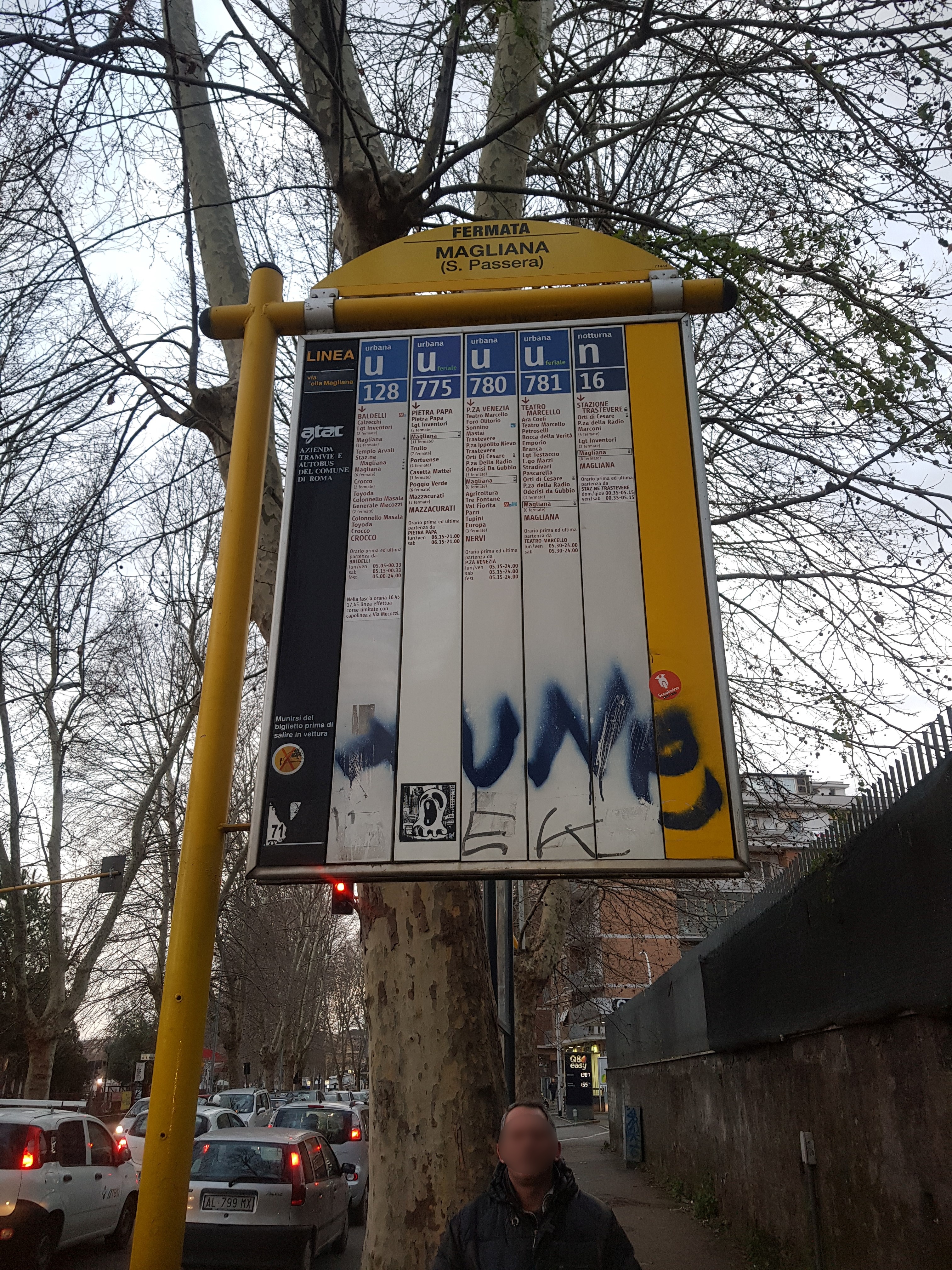
Magliana/St. Passera stop - Tuesday schedule
| Line | Direction | Time |
|---|---|---|
| N781 | Magliana/Scarperia | 3:23 AM |
| N781 | Magliana/Scarperia | 3:23 AM |
| N781 | Magliana/Scarperia | 4:03 AM |
| N781 | Magliana/Scarperia | 4:03 AM |
| N781 | Magliana/Scarperia | 4:43 AM |
| N781 | Magliana/Scarperia | 4:43 AM |
| 128 | Crocco | 5:09 AM |
| 128 | Crocco | 5:23 AM |
| N781 | Magliana/Scarperia | 5:23 AM |
| N781 | Magliana/Scarperia | 5:23 AM |
| 780 | Nervi/Sports Palace | 5:27 AM |
| 128 | Crocco | 5:36 AM |
| 780 | Nervi/Sports Palace | 5:41 AM |
| 128 | Crocco | 5:50 AM |
| 781 | Magliana/Scarperia | 5:51 AM |
| 780 | Nervi/Sports Palace | 5:56 AM |
| 128 | Crocco | 6:03 AM |
| 781 | Magliana/Scarperia | 6:07 AM |
| 780 | Nervi/Sports Palace | 6:11 AM |
| 128 | Crocco | 6:20 AM |
| 781 | Magliana/Scarperia | 6:21 AM |
| 780 | Nervi/Sports Palace | 6:26 AM |
| 775 | Nazzani | 6:27 AM |
| 781 | Magliana/Scarperia | 6:34 AM |
| 128 | Crocco | 6:36 AM |
Directions to Magliana/St. Passera stop (Roma) with public transit
The following transit lines have routes that pass near Magliana/St. Passera
 Bus: 128, 775, 780, 781, 710.
- Train: FL1, FL3, FL5, R, R.
- Metro: B.
How to get to Magliana/St. Passera stop by bus?
Click on the bus route to see step by step directions with maps, line arrival times and updated time schedules.
How to get to Magliana/St. Passera stop by train?
Click on the train route to see step by step directions with maps, line arrival times and updated time schedules.
How to get to Magliana/St. Passera stop by metro?
Click on the metro route to see step by step directions with maps, line arrival times and updated time schedules.
Bus stops near Magliana/St. Passera stop in Roma
- Greppi/Vigna Pia, 1 min walk,
- Magliana/St. Passera, 1 min walk,
- Trastevere Station (Rail), 9 min walk,
Train stations near Magliana/St. Passera station in Roma
- Roma Trastevere, 11 min walk,
- St. Paul's Basilica, 18 min walk,
Metro stations near Magliana/St. Passera station in Roma
- St. Paul's Basilica, 18 min walk,
Bus lines to Magliana/St. Passera stop in Roma
- 710, Lenin,
- 128, Crocco,
- 775, Nazzani,
- 780, Nervi/Sports Palace,
- 781, Magliana/Scarperia,
- N781, Trastevere Station,
- 3, Valle Giulia,
What are the closest stations to Magliana/St. Passera?
The closest stations to Magliana/St. Passera are:
- Greppi/Vigna Pia stop is 18 meters away, 1 min walk.
- Magliana/St. Passera stop is 58 meters away, 1 min walk.
- Trastevere Station (Rail) is 673 meters away, 9 min walk.
- Roma Trastevere station is 849 meters away, 11 min walk.
- St. Paul's Basilica station is 1406 meters away, 18 min walk.
Which bus lines stop near Magliana/St. Passera?
These bus lines stop near Magliana/St. Passera: 128, 775, 780, 781.
Which train lines stop near Magliana/St. Passera?
These train lines stop near Magliana/St. Passera: FL1, FL3, FL5.
Which metro line stops near Magliana/St. Passera?
B (Laurentina)
What’s the nearest metro station to Magliana/St. Passera in Roma?
The nearest metro station to Magliana/St. Passera in Roma is St. Paul's Basilica. It’s a 18 min walk away.
What’s the nearest train station to Magliana/St. Passera in Roma?
The nearest train station to Magliana/St. Passera in Roma is Roma Trastevere. It’s a 11 min walk away.
What’s the nearest bus station to Magliana/St. Passera in Roma?
The nearest bus stations to Magliana/St. Passera in Roma are Greppi/Vigna Pia and Magliana/St. Passera. The closest one is a 1 min walk away.
What time is the first light rail to Magliana/St. Passera in Roma?
The 3 is the first light rail that goes to Magliana/St. Passera in Roma. It stops nearby at 5:42 AM.
What time is the last light rail to Magliana/St. Passera in Roma?
The 3 is the last light rail that goes to Magliana/St. Passera in Roma. It stops nearby at 1:40 AM.
What time is the first metro to Magliana/St. Passera in Roma?
The B is the first metro that goes to Magliana/St. Passera in Roma. It stops nearby at 5:40 AM.
What time is the last metro to Magliana/St. Passera in Roma?
The B is the last metro that goes to Magliana/St. Passera in Roma. It stops nearby at 11:58 PM.
What time is the first train to Magliana/St. Passera in Roma?
The FC2 is the first train that goes to Magliana/St. Passera in Roma. It stops nearby at 5:18 AM.
What time is the last train to Magliana/St. Passera in Roma?
The FC2 is the last train that goes to Magliana/St. Passera in Roma. It stops nearby at 12:04 AM.
What time is the first bus to Magliana/St. Passera in Roma?
The N781 is the first bus that goes to Magliana/St. Passera in Roma. It stops nearby at 3:00 AM.
What time is the last bus to Magliana/St. Passera in Roma?
The N781 is the last bus that goes to Magliana/St. Passera in Roma. It stops nearby at 3:03 AM.
Magliana/St. Passera station
 Taken by Anonymous
See Magliana/St. Passera stop, Roma, on the map
Public transit to Magliana/St. Passera stop (ID: 71444) in Roma
Looking for directions to Magliana/St. Passera in Roma, Italy?
Download the Moovit App to find the current schedule and step-by-step directions for Bus, Metro or Train routes that pass through Magliana/St. Passera.
Looking for the nearest stops closest to Magliana/St. Passera ? Check out this list of closest stops to your destination: Greppi/Vigna Pia; Magliana/St. Passera; Trastevere Station (Rail); Roma Trastevere; St. Paul's Basilica.
Bus: 128, 775, 780, 781, 710, N781, 3.Train: FL1, FL3, FL5, R, R, R, RV, FC2.Metro: B.
We make riding on public transit to Magliana/St. Passera easy, which is why over 1.7 billion users, including users in Roma trust Moovit as the best app for public transit.
Use the app to navigate to popular places including to the airport, hospital, stadium, grocery store, mall, coffee shop, school, college, and university.
Magliana/St. Passera stop’s code is 71444
The first line to this stop is N781, at 3:23 AM, and the last line is N781 at 2:43 AM.
Vicolo di Santa Passera, Roma, Italy
This stop serves ATAC’s lines
- Greppi/Vigna Pia,
- Magliana/St. Passera,
- Trastevere Station (Rail)
Bus stops near Magliana/St. Passera stop
- Roma Trastevere,
- St. Paul's Basilica
Train stations near Magliana/St. Passera station
- St. Paul's Basilica
Metro station near Magliana/St. Passera station
- Sanzio Waterfront/Filipperi,
- Independence,
- Trinity of the Mountains,
- Longone | Fassinoro,
- Magliana/Villa Bonelli,
- Bella Farnia Via Migliara,
- Roma Anagnina (Platform 11 Cotral Departures),
- Mameli,
- Alghero,
- Jonio/Talenti,
- Viterbo | Via Cimina (Barracks),
- Tivoli,
- Vetralla | Via Cassia (Km 62),
- Rieti | Lower Cottano,
- Conservatory,
- Labicana,
- Teano,
- Roma Tuscolana,
- Ciciliano | Empolitana Road (Km 15),
- Rome Rebibbia (Metro B)
Popular public transit stations in Roma
Get around Roma by public transit!
Traveling around Roma has never been so easy. See step by step directions as you travel to any attraction, street or major public transit station. View bus and train schedules, arrival times, service alerts and detailed routes on a map, so you know exactly how to get to anywhere in Roma.
When traveling to any destination around Roma use Moovit's Live Directions with Get Off Notifications to know exactly where and how far to walk, how long to wait for your line, and how many stops are left. Moovit will alert you when it's time to get off — no need to constantly re-check whether yours is the next stop.
Wondering how to use public transit in Roma or how to pay for public transit in Roma? Moovit public transit app can help you navigate your way with public transit easily, and at minimum cost. It includes public transit fees, ticket prices, and costs. Looking for a map of Roma public transit lines? Moovit public transit app shows all public transit maps in Roma with all Bus, Train, Metro, Light Rail, Ferry, Funicular and Gondola routes and stops on an interactive map.
Rome and Lazio has 7 transit type(s), including: Bus, Train, Metro, Light Rail, Ferry, Funicular and Gondola, operated by several transit agencies, including ATAC, Cotral, Trenitalia, Troiani Transportation Services, BIS, ATR Mobility, Tuscia, Shuttle, Seatour, Troiani Bus Lines, CSC Mobility, Terravision, ATRAL, Tambus and Sitbus