How to get to Manathan by bus?
Click on the bus route to see step by step directions with maps, line arrival times and updated time schedules.
From Four Points by Sheraton New York Downtown, Manhattan
71 minFrom Orchard St, Manhattan
61 minFrom Castle Hill, Bronx
77 minFrom Tribeca, Manhattan
83 minFrom Greyhound NYC To Foxwoods Casino, Bronx
74 minFrom Minetta Lane Theatre, Manhattan
70 minFrom 28 Liberty, Manhattan
74 minFrom New York Presbyterian Hospital-Columbia Presbyterian Medical Center, Manhattan
47 minFrom The Public Theater, Manhattan
56 min
How to get to Manathan by train?
Click on the train route to see step by step directions with maps, line arrival times and updated time schedules.
From Four Points by Sheraton New York Downtown, Manhattan
192 minFrom Tribeca, Manhattan
188 minFrom Minetta Lane Theatre, Manhattan
146 minFrom 28 Liberty, Manhattan
190 minFrom New York Presbyterian Hospital-Columbia Presbyterian Medical Center, Manhattan
60 minFrom The Public Theater, Manhattan
152 min
How to get to Manathan by subway?
Click on the subway route to see step by step directions with maps, line arrival times and updated time schedules.
From Four Points by Sheraton New York Downtown, Manhattan
42 minFrom Orchard St, Manhattan
36 minFrom Castle Hill, Bronx
47 minFrom Tribeca, Manhattan
41 minFrom Greyhound NYC To Foxwoods Casino, Bronx
35 minFrom Minetta Lane Theatre, Manhattan
29 minFrom 28 Liberty, Manhattan
42 minFrom New York Presbyterian Hospital-Columbia Presbyterian Medical Center, Manhattan
39 minFrom The Public Theater, Manhattan
35 min
Subway stations near Manathan in Manhattan
- 96 St, 6 min walk,VIEW
Bus stops near Manathan in Manhattan
Bus lines to Manathan in Manhattan
- BXM3, Yonkers - Midtown,VIEW
- BXM4, Woodlawn - Midtown,VIEW
- BXM7, Co-Op City - Midtown,VIEW
- M1, Harlem - East Village,VIEW
- M2, Washington Heights - East Village,VIEW
- M3, Fort George - East Village,VIEW
- M4, The Cloisters - 32 St,VIEW
- M96, East Side 1 Av Crosstown,VIEW
- M106, East Harlem Fdr Drive Crosstown,VIEW
- M10, Harlem 159 St Via 8 Av,VIEW
- 28, 23rd St @ 5th Ave,VIEW
- BXM2, West Midtown Penn Sta-34 St Via Kappock St,VIEW
- BXM11, East Midtown 23 St Via Bronx Riv Pky Via 5 Av,VIEW
What are the closest stations to Manathan?
The closest stations to Manathan are:
- 96 St is 512 yards away, 6 min walk.
- 5 Av/E 96 St is 529 yards away, 7 min walk.
- E 96 St/5 Av is 545 yards away, 7 min walk.
- Central Park West/W 97 St is 585 yards away, 7 min walk.
- 5th Ave @ 98th St is 624 yards away, 8 min walk.
- 5 Av/E 98 St is 657 yards away, 8 min walk.
Which bus lines stop near Manathan?
These bus lines stop near Manathan: BX4A, BXM11, BXM2, M1, M10, M2, M4, M96.
Which train lines stop near Manathan?
These train lines stop near Manathan: 1, 3.
Which subway lines stop near Manathan?
These subway lines stop near Manathan: 6, 6X, B, C.
What’s the nearest subway station to Manathan in Manhattan?
The nearest subway station to Manathan in Manhattan is 96 St. It’s a 6 min walk away.
What’s the nearest bus station to Manathan in Manhattan?
The nearest bus stations to Manathan in Manhattan are 5 Av/E 96 St, E 96 St/5 Av and Central Park West/W 97 St. The closest one is a 7 min walk away.
What time is the first subway to Manathan in Manhattan?
The A is the first subway that goes to Manathan in Manhattan. It stops nearby at 3:00 AM.
What time is the last subway to Manathan in Manhattan?
The A is the last subway that goes to Manathan in Manhattan. It stops nearby at 4:09 AM.
What time is the first bus to Manathan in Manhattan?
The M96 is the first bus that goes to Manathan in Manhattan. It stops nearby at 3:05 AM.
What time is the last bus to Manathan in Manhattan?
The M96 is the last bus that goes to Manathan in Manhattan. It stops nearby at 2:49 AM.
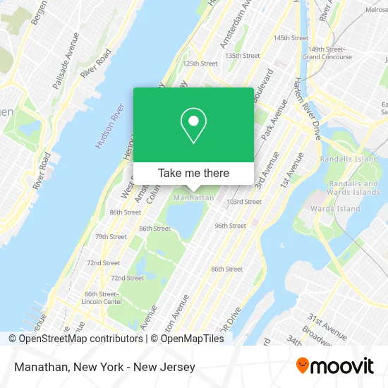
See Manathan, Manhattan, on the map
Public Transit to Manathan in Manhattan
Wondering how to get to Manathan in Manhattan? Moovit helps you find the best way to get to Manathan with step-by-step directions from the nearest public transit station.
Moovit provides free maps and live directions to help you navigate through your city. View schedules, routes, timetables, and find out how long does it take to get to Manathan in real time.
Looking for the nearest stop or station to Manathan? Check out this list of stops closest to your destination: 96 St; 5 Av/E 96 St; E 96 St/5 Av; Central Park West/W 97 St; 5th Ave @ 98th St; 5 Av/E 98 St.
Bus: BX4A, BXM11, BXM2, M1, M10, M2, M4, M96, BXM3, BXM4, BXM7, M3, M106.Train: 1, 3.Subway: 6, 6X, B, C, A, 4.
Want to see if there’s another route that gets you there at an earlier time? Moovit helps you find alternative routes or times. Get directions from and directions to Manathan easily from the Moovit App or Website.
We make riding to Manathan easy, which is why over 1.5 million users, including users in Manhattan, trust Moovit as the best app for public transit. You don’t need to download an individual bus app or train app, Moovit is your all-in-one transit app that helps you find the best bus time or train time available.
For information on prices of subway, bus and train, costs and ride fares to Manathan, please check the Moovit app.
Use the app to navigate to popular places including to the airport, hospital, stadium, grocery store, mall, coffee shop, school, college, and university.
Location: Manhattan, New York - New Jersey
- Mahatans,
- Borough Of Manhattan,
- Cabrini Hospice,
- Black Petals Flowers,
- Central Park - North Meadow Recreation Center,
- Johnson Strategic,
- North Meadow Recreation Center,
- North Meadow Field 12,
- Central Park,
- Central Park Tennis Center,
- Manhattan Piano Academy,
- Neu Space Llc,
- Headway Finance,
- Central Park - North Meadow Fields 1-4,
- Central Park - East Drive,
- Grandson Domestic Services,
- Squirrel Alley,
- Central Park-Jackie Kennedy Onassis Reservoir.,
- Central Park East Meadow Oval,
- Statue Of Albert Bertel Thorvaldsen
Places Near Manathan (Manhattan)
- Chinatown, Manhattan,
- 3 Stone St, Manhattan,
- Katz's Deli, Manhattan,
- 376 Hudson Street, Manhattan,
- San Gennaro Feast, Manhattan,
- 1 Police Plaza, Manhattan,
- qqqq, Manhattan,
- Hudson Yards, Manhattan,
- Wall Street, Manhattan,
- Queens Center Mall, Queens,
- SoHo, Manhattan,
- 66 John Street, Manhattan,
- 911 Memorial, Manhattan,
- 26 Federal Plaza, Manhattan,
- Mountainside Hospital, Glen Ridge,
- Pier 83, Manhattan,
- Times Square, Manhattan,
- 111 Centre New York City Supreme Court, Manhattan,
- Rockefeller Center, Manhattan,
- Bellevue Hospital, Manhattan
How to get to popular places in New York - New Jersey with public transit
Get around Manhattan by public transit!
Traveling around Manhattan has never been so easy. See step by step directions as you travel to any attraction, street or major public transit station. View bus and train schedules, arrival times, service alerts and detailed routes on a map, so you know exactly how to get to anywhere in Manhattan.
When traveling to any destination around Manhattan use Moovit's Live Directions with Get Off Notifications to know exactly where and how far to walk, how long to wait for your line, and how many stops are left. Moovit will alert you when it's time to get off — no need to constantly re-check whether yours is the next stop.
Wondering how to use public transit in Manhattan or how to pay for public transit in Manhattan? Moovit public transit app can help you navigate your way with public transit easily, and at minimum cost. It includes public transit fees, ticket prices, and costs. Looking for a map of Manhattan public transit lines? Moovit public transit app shows all public transit maps in Manhattan with all Bus, Train, Subway, Light Rail, Ferry and Cable Car routes and stops on an interactive map.
New York - New Jersey has 6 transit type(s), including: Bus, Train, Subway, Light Rail, Ferry and Cable Car, operated by several transit agencies, including MTA Subway, Metro-North Railroad, LIRR, PATH, MTA New York City Transit - Express routes, MTA Bus, NJ Transit, NYC Ferry, NICE bus, Bee-Line Bus, NJ Transit Rail, Norwalk Transit District, Hartford Line, River Valley Transit and HART