Memorial Dr @ West Forest Dr stop - Monday schedule
| Line | Direction | Time |
|---|---|---|
| 162 | Addicks P&R - Westbound | 6:30 AM |
| 162 | Addicks P&R - Westbound | 7:00 AM |
| 162 | Addicks P&R - Westbound | 7:30 AM |
| 162 | Addicks P&R - Westbound | 8:00 AM |
| 162 | Addicks P&R - Westbound | 8:29 AM |
| 162 | Addicks P&R - Westbound | 8:59 AM |
| 162 | Addicks P&R - Westbound | 9:27 AM |
| 162 | Addicks P&R - Westbound | 9:57 AM |
| 162 | Addicks P&R - Westbound | 10:27 AM |
| 162 | Addicks P&R - Westbound | 10:57 AM |
| 162 | Addicks P&R - Westbound | 11:27 AM |
| 162 | Addicks P&R - Westbound | 12:00 PM |
| 162 | Addicks P&R - Westbound | 12:30 PM |
| 162 | Addicks P&R - Westbound | 1:00 PM |
| 162 | Addicks P&R - Westbound | 1:30 PM |
| 162 | Addicks P&R - Westbound | 2:00 PM |
| 162 | Addicks P&R - Westbound | 2:34 PM |
| 162 | Addicks P&R - Westbound | 3:04 PM |
| 162 | Addicks P&R - Westbound | 3:34 PM |
| 162 | Addicks P&R - Westbound | 4:04 PM |
| 162 | Addicks P&R - Westbound | 4:34 PM |
| 162 | Addicks P&R - Westbound | 5:04 PM |
| 162 | Addicks P&R - Westbound | 5:32 PM |
| 162 | Addicks P&R - Westbound | 6:02 PM |
| 162 | Addicks P&R - Westbound | 6:28 PM |
Directions to Memorial Dr @ West Forest Dr stop (Houston) with public transit
The following transit lines have routes that pass near Memorial Dr @ West Forest Dr
 Bus: 162, 161.
How to get to Memorial Dr @ West Forest Dr stop by bus?
Click on the bus route to see step by step directions with maps, line arrival times and updated time schedules.
Bus stops near Memorial Dr @ West Forest Dr stop in Houston
- Memorial Dr @ West Forest Dr, 1 min walk,
- Wilcrest Dr @ Memorial Dr, 13 min walk,
Bus lines to Memorial Dr @ West Forest Dr stop in Houston
- 162, Downtown Tc - Eastbound,
- 161, Downtown Tc - Eastbound,
What are the closest stations to Memorial Dr @ West Forest Dr?
The closest stations to Memorial Dr @ West Forest Dr are:
- Memorial Dr @ West Forest Dr stop is 56 yards away, 1 min walk.
- Wilcrest Dr @ Memorial Dr stop is 1064 yards away, 13 min walk.
Which bus line stops near Memorial Dr @ West Forest Dr?
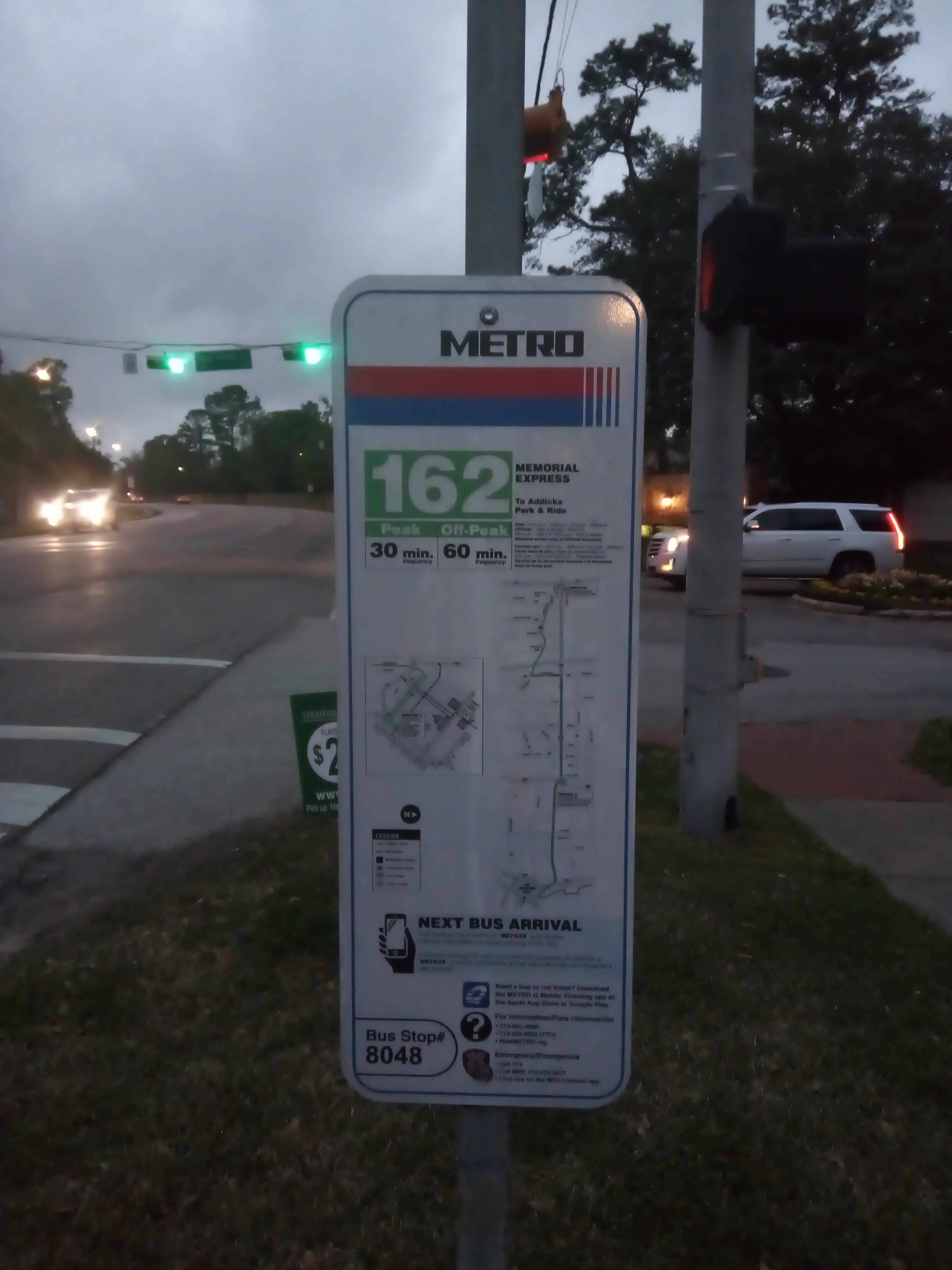
162 (Addicks P&R - Westbound)
What’s the nearest bus station to Memorial Dr @ West Forest Dr in Houston?
The nearest bus station to Memorial Dr @ West Forest Dr in Houston is Memorial Dr @ West Forest Dr. It’s a 1 min walk away.
What time is the first bus to Memorial Dr @ West Forest Dr in Houston?
The 161 is the first bus that goes to Memorial Dr @ West Forest Dr in Houston. It stops nearby at 4:37 AM.
What time is the last bus to Memorial Dr @ West Forest Dr in Houston?
The 162 is the last bus that goes to Memorial Dr @ West Forest Dr in Houston. It stops nearby at 12:56 AM.
Memorial Dr @ West Forest Dr station
 Taken by Marshall T.
See Memorial Dr @ West Forest Dr stop, Houston, on the map
Public transit to Memorial Dr @ West Forest Dr stop (ID: 8048) in Houston
Looking for directions to Memorial Dr @ West Forest Dr in Houston, United States?
Download the Moovit App to find the current schedule and step-by-step directions for Bus routes that pass through Memorial Dr @ West Forest Dr.
Looking for the nearest stops closest to Memorial Dr @ West Forest Dr ? Check out this list of closest stops to your destination: Memorial Dr @ West Forest Dr; Wilcrest Dr @ Memorial Dr.
Bus: 162, 161.
We make riding on public transit to Memorial Dr @ West Forest Dr easy, which is why over 1.7 billion users, including users in Houston trust Moovit as the best app for public transit.
Use the app to navigate to popular places including to the airport, hospital, stadium, grocery store, mall, coffee shop, school, college, and university.
Memorial Dr @ West Forest Dr stop’s code is 8048
The first line to this stop is 162, at 6:30 AM, and the last line is 162 at 12:55 AM.
702 W Forest Dr, Houston, TX, USA
This stop serves METRO’s lines
- Memorial Dr @ West Forest Dr,
- Wilcrest Dr @ Memorial Dr
Bus stops near Memorial Dr @ West Forest Dr stop
- Harwin Dr @ Savoy Dr,
- North Freeway @ Plaza Verde Dr,
- Holman St @ Main St,
- Airmail Rd @ Pallet Rd,
- Magnolia Transit Center,
- Beechnut St @ Jorine Dr,
- Fondren Rd @ Westpark Dr,
- Tidwell Rd @ Airline Dr,
- Smith St @ Preston St,
- Antoine Dr @ W Little York Rd,
- Woodridge Dr @ Village Way,
- Old Spanish Trail @ Dupont St,
- S Post Oak Rd @ Anderson Oaks St,
- Eastex Freeway @ Hopper Rd,
- Robertson Stadium/Uh/Tsu,
- Bissonnet St @ Country Creek Dr,
- Fm 1960 Rd @ Ella Blvd,
- W Montgomery Rd @ W Mt Houston Rd,
- N Shepherd Dr @ W 10th St,
- Bellaire Blvd @ Winkleman Rd
Popular public transit stations in Houston
Get around Houston by public transit!
Traveling around Houston has never been so easy. See step by step directions as you travel to any attraction, street or major public transit station. View bus and train schedules, arrival times, service alerts and detailed routes on a map, so you know exactly how to get to anywhere in Houston.
When traveling to any destination around Houston use Moovit's Live Directions with Get Off Notifications to know exactly where and how far to walk, how long to wait for your line, and how many stops are left. Moovit will alert you when it's time to get off — no need to constantly re-check whether yours is the next stop.
Wondering how to use public transit in Houston or how to pay for public transit in Houston? Moovit public transit app can help you navigate your way with public transit easily, and at minimum cost. It includes public transit fees, ticket prices, and costs. Looking for a map of Houston public transit lines? Moovit public transit app shows all public transit maps in Houston with all Bus and Light Rail routes and stops on an interactive map.
Houston has 2 transit type(s), including: Bus and Light Rail, operated by several transit agencies, including METRO, Greyhound-us and FlixBus-us