Menichella/Astuti stop - Monday schedule
| Line | Direction | Time |
|---|---|---|
| 344 | Nuovo Salario Station | 5:39 AM |
| 444 | Ponte Mammolo Metro B Station | 5:48 AM |
| 344 | Nuovo Salario Station | 5:58 AM |
| 344 | Eretum | 6:06 AM |
| 444 | Ponte Mammolo Metro B Station | 6:17 AM |
| 344 | Nuovo Salario Station | 6:18 AM |
| 344 | Nuovo Salario Station | 6:38 AM |
| 344 | Eretum | 6:38 AM |
| 444 | Ponte Mammolo Metro B Station | 6:46 AM |
| 344 | Nuovo Salario Station | 6:59 AM |
| 344 | Eretum | 7:04 AM |
| 444 | Ponte Mammolo Metro B Station | 7:07 AM |
| 435 | Val Di Lanzo | 7:11 AM |
| 344 | Nuovo Salario Station | 7:21 AM |
| 444 | Ponte Mammolo Metro B Station | 7:27 AM |
| 344 | Nuovo Salario Station | 7:42 AM |
| 444 | Ponte Mammolo Metro B Station | 7:47 AM |
| 344 | Eretum | 7:50 AM |
| 344 | Nuovo Salario Station | 8:02 AM |
| 444 | Ponte Mammolo Metro B Station | 8:07 AM |
| 344 | Nuovo Salario Station | 8:23 AM |
| 344 | Eretum | 8:25 AM |
| 444 | Ponte Mammolo Metro B Station | 8:32 AM |
| 344 | Nuovo Salario Station | 8:55 AM |
| 444 | Ponte Mammolo Metro B Station | 8:57 AM |
Directions to Menichella/Astuti stop (Roma) with public transit
The following transit lines have routes that pass near Menichella/Astuti
 Bus: 343, 404, 444, 344, 424.
- Metro: B.
How to get to Menichella/Astuti stop by bus?
Click on the bus route to see step by step directions with maps, line arrival times and updated time schedules.
How to get to Menichella/Astuti stop by metro?
Click on the metro route to see step by step directions with maps, line arrival times and updated time schedules.
Bus stops near Menichella/Astuti stop in Roma
- Jemolo, 2 min walk,
- Cappi, 5 min walk,
- Fabriano, 10 min walk,
- Montegiorgio/Corinaldo, 12 min walk,
Metro stations near Menichella/Astuti station in Roma
- St. Mary of Rescue, 27 min walk,
Bus lines to Menichella/Astuti stop in Roma
- 344, Nuovo Salario Station,
- 444, Ponte Mammolo Metro B Station,
- 404, Rebibbia (Metro B),
- 343, Ponte Mammolo (Metro B),
- 424, Ponte Mammolo (Metro B),
What are the closest stations to Menichella/Astuti?
The closest stations to Menichella/Astuti are:
- Jemolo stop is 147 meters away, 2 min walk.
- Cappi stop is 361 meters away, 5 min walk.
- Fabriano stop is 759 meters away, 10 min walk.
- Montegiorgio/Corinaldo stop is 903 meters away, 12 min walk.
- St. Mary of Rescue station is 2069 meters away, 27 min walk.
Which bus lines stop near Menichella/Astuti?
These bus lines stop near Menichella/Astuti: 343, 404, 444.
Which metro line stops near Menichella/Astuti?
B (Rebibbia/Jonio)
What’s the nearest metro station to Menichella/Astuti in Roma?
The nearest metro station to Menichella/Astuti in Roma is St. Mary of Rescue. It’s a 27 min walk away.
What’s the nearest bus station to Menichella/Astuti in Roma?
The nearest bus station to Menichella/Astuti in Roma is Jemolo. It’s a 2 min walk away.
What time is the first metro to Menichella/Astuti in Roma?
The B is the first metro that goes to Menichella/Astuti in Roma. It stops nearby at 5:30 AM.
What time is the last metro to Menichella/Astuti in Roma?
The B is the last metro that goes to Menichella/Astuti in Roma. It stops nearby at 12:09 AM.
What time is the first bus to Menichella/Astuti in Roma?
The 343 is the first bus that goes to Menichella/Astuti in Roma. It stops nearby at 5:16 AM.
What time is the last bus to Menichella/Astuti in Roma?
The 444 is the last bus that goes to Menichella/Astuti in Roma. It stops nearby at 2:17 AM.
Menichella/Astuti station
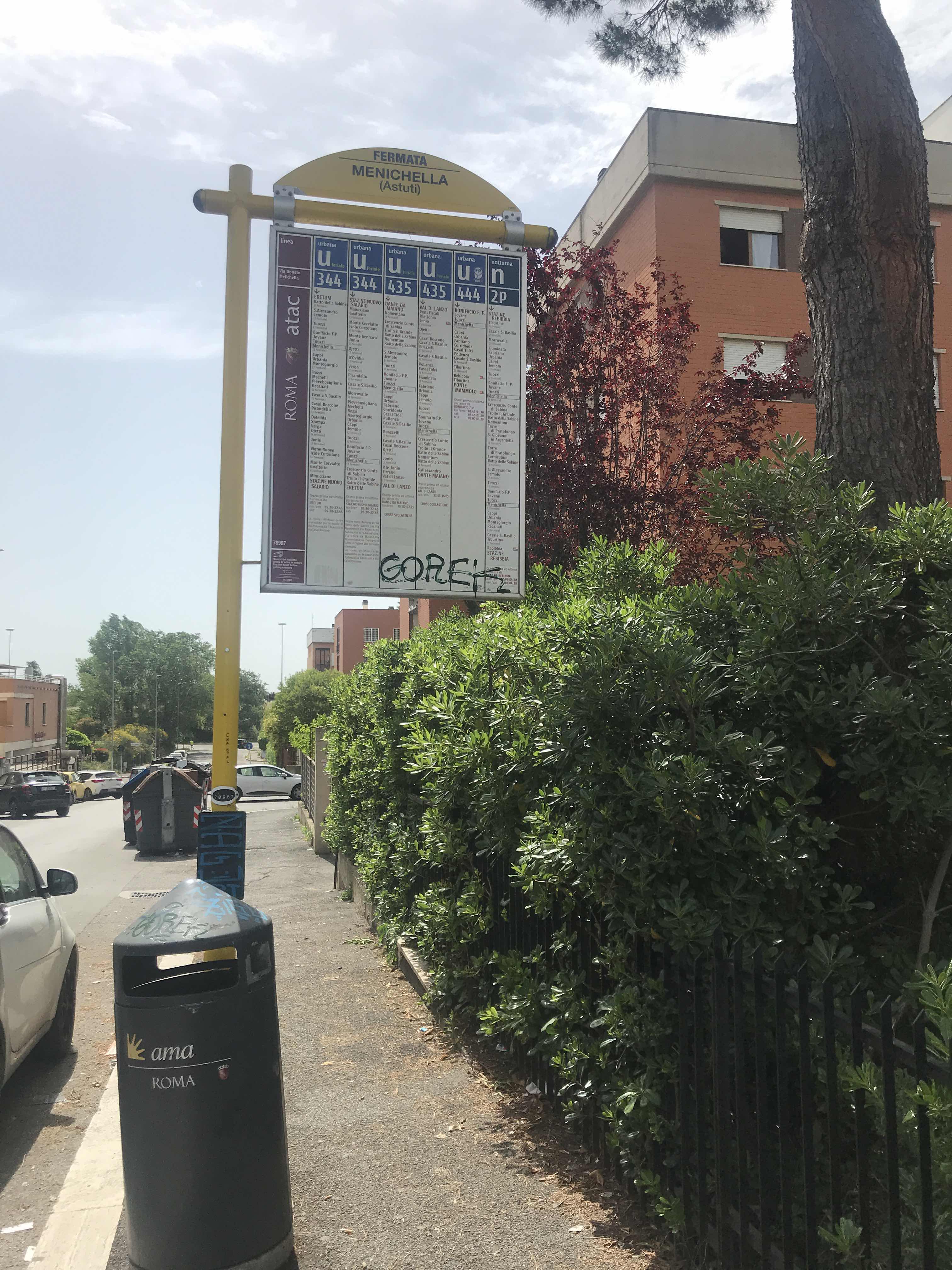 Taken by Anonymous
See Menichella/Astuti stop, Roma, on the map
Public transit to Menichella/Astuti stop (ID: 78987) in Roma
Looking for directions to Menichella/Astuti in Roma, Italy?
Download the Moovit App to find the current schedule and step-by-step directions for Bus or Metro routes that pass through Menichella/Astuti.
Looking for the nearest stops closest to Menichella/Astuti ? Check out this list of closest stops to your destination: Jemolo; Cappi; Fabriano; Montegiorgio/Corinaldo; St. Mary of Rescue.
Bus: 343, 404, 444, 344, 424.Metro: B.
We make riding on public transit to Menichella/Astuti easy, which is why over 1.7 billion users, including users in Roma trust Moovit as the best app for public transit.
Use the app to navigate to popular places including to the airport, hospital, stadium, grocery store, mall, coffee shop, school, college, and university.
Menichella/Astuti stop’s code is 78987
The first line to this stop is 344, at 5:39 AM, and the last line is 444 at 1:32 AM.
This stop serves ATAC and ATR Mobility’s lines
- Jemolo,
- Cappi,
- Fabriano,
- Montegiorgio/Corinaldo
Bus stops near Menichella/Astuti stop
- St. Mary of Rescue
Metro station near Menichella/Astuti station
- Vittorio Emanuele III Avenue,
- De Filippo/Pica,
- Kennedy/Ciampino Railway Station,
- Via Piave, 19,
- Sacred Cave Monastery - Subiaco,
- Piediluco,
- Ballarin,
- Ventotene,
- Jonio/Talenti,
- Ladispoli, Falcone Square,
- Civitavecchia | San Paolo Hospital,
- Villa Cavalletti (School Institute),
- Italian Forum/Sports Fields,
- Marinetti/Rebora,
- Guidonia - Via Tiburtina (Setteville),
- Chiaia Di Luna,
- Val D'Ala,
- Laurentina/Three Fountains,
- Santa Maria Delle Mole | Appia Road (Ice Palace),
- Ceccano
Popular public transit stations in Roma
Get around Roma by public transit!
Traveling around Roma has never been so easy. See step by step directions as you travel to any attraction, street or major public transit station. View bus and train schedules, arrival times, service alerts and detailed routes on a map, so you know exactly how to get to anywhere in Roma.
When traveling to any destination around Roma use Moovit's Live Directions with Get Off Notifications to know exactly where and how far to walk, how long to wait for your line, and how many stops are left. Moovit will alert you when it's time to get off — no need to constantly re-check whether yours is the next stop.
Wondering how to use public transit in Roma or how to pay for public transit in Roma? Moovit public transit app can help you navigate your way with public transit easily, and at minimum cost. It includes public transit fees, ticket prices, and costs. Looking for a map of Roma public transit lines? Moovit public transit app shows all public transit maps in Roma with all Bus, Train, Metro, Light Rail, Ferry, Funicular and Gondola routes and stops on an interactive map.
Rome and Lazio has 7 transit type(s), including: Bus, Train, Metro, Light Rail, Ferry, Funicular and Gondola, operated by several transit agencies, including ATAC, Cotral, Trenitalia, Troiani Transportation Services, BIS, ATR Mobility, Tuscia, Shuttle, Seatour, Troiani Bus Lines, CSC Mobility, Terravision, ATRAL, Tambus and Sitbus