Directions to Metropolitan Studio (Baltimore) with public transportation
The following transit lines have routes that pass near Metropolitan Studio
 Bus: 21, 22, 94, CITYLINK GOLD.
- Metro: METRO.
- Light Rail: LIGHT RAILLINK.
How to get to Metropolitan Studio by bus?
Click on the bus route to see step by step directions with maps, line arrival times and updated time schedules.
From Morgan State University, Baltimore
46 minFrom I-695 Exit 29 (Loch Raven Blvd (MD 542)/Cromwell Bridge Rd), Baltimore County
59 minFrom Pigtown / Washington Village, Baltimore
44 minFrom City Hall Fields, Baltimore
37 minFrom Bwi2 Employee Shuttles, Baltimore
54 minFrom Walmart, Baltimore County
61 minFrom Johns Hopkins Medicine at Green Spring Station, Baltimore County
41 minFrom Ravens Walk @ M&T Bank Stadium, Baltimore
44 minFrom Baltimore Marriott Waterfront, Baltimore
46 minFrom University Of Maryland Baltimore (Umbc), Baltimore County
70 min
How to get to Metropolitan Studio by metro?
Click on the metro route to see step by step directions with maps, line arrival times and updated time schedules.
Bus stops near Metropolitan Studio in Baltimore
Metro station near Metropolitan Studio in Baltimore
- Mondawmin Metro, 7 min walk,VIEW
Light Rail stations near Metropolitan Studio in Baltimore
- Woodberry, 36 min walk,VIEW
Bus lines to Metropolitan Studio in Baltimore
What are the closest stations to Metropolitan Studio?
The closest stations to Metropolitan Studio are:
- Clipper Rd & Union Ave is 61 yards away, 2 min walk.
- 41st St & Hooper Ave Opp Eb is 369 yards away, 5 min walk.
- Mondawmin Metro is 509 yards away, 7 min walk.
- Due 36th & Poole is 889 yards away, 11 min walk.
- Falls Rd & Union Ave Sb is 904 yards away, 11 min walk.
- Woodberry is 3007 yards away, 36 min walk.
Which bus lines stop near Metropolitan Studio?
These bus lines stop near Metropolitan Studio: 21, 22, 94.
Which metro line stops near Metropolitan Studio?
METRO (Towards Owing Mills)
Which light rail line stops near Metropolitan Studio?
LIGHT RAILLINK (Northbound)
What’s the nearest metro station to Metropolitan Studio in Baltimore?
The nearest metro station to Metropolitan Studio in Baltimore is Mondawmin Metro. It’s a 7 min walk away.
What’s the nearest bus station to Metropolitan Studio in Baltimore?
The nearest bus station to Metropolitan Studio in Baltimore is Clipper Rd & Union Ave. It’s a 2 min walk away.
What time is the first light rail to Metropolitan Studio in Baltimore?
The LIGHT RAILLINK is the first light rail that goes to Metropolitan Studio in Baltimore. It stops nearby at 4:26 AM.
What time is the last light rail to Metropolitan Studio in Baltimore?
The LIGHT RAILLINK is the last light rail that goes to Metropolitan Studio in Baltimore. It stops nearby at 12:47 AM.
What time is the first metro to Metropolitan Studio in Baltimore?
The METRO is the first metro that goes to Metropolitan Studio in Baltimore. It stops nearby at 5:01 AM.
What time is the last metro to Metropolitan Studio in Baltimore?
The METRO is the last metro that goes to Metropolitan Studio in Baltimore. It stops nearby at 12:18 AM.
What time is the first bus to Metropolitan Studio in Baltimore?
The 22 is the first bus that goes to Metropolitan Studio in Baltimore. It stops nearby at 3:48 AM.
What time is the last bus to Metropolitan Studio in Baltimore?
The 94 is the last bus that goes to Metropolitan Studio in Baltimore. It stops nearby at 2:47 AM.
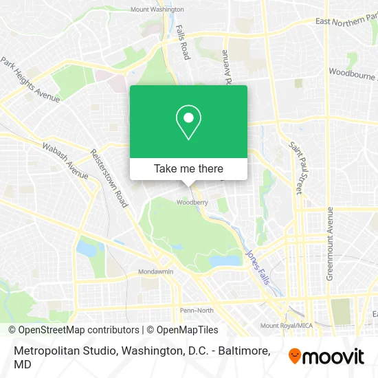
See Metropolitan Studio, Baltimore, on the map
Public Transit to Metropolitan Studio in Baltimore
Wondering how to get to Metropolitan Studio in Baltimore? Moovit helps you find the best way to get to Metropolitan Studio with step-by-step directions from the nearest public transit station.
Moovit provides free maps and live directions to help you navigate through your city. View schedules, routes, timetables, and find out how long does it take to get to Metropolitan Studio in real time.
Looking for the nearest stop or station to Metropolitan Studio? Check out this list of stops closest to your destination: Clipper Rd & Union Ave; 41st St & Hooper Ave Opp Eb; Mondawmin Metro; Due 36th & Poole; Falls Rd & Union Ave Sb; Woodberry.
Bus: 21, 22, 94, CITYLINK GOLD.Metro: METRO.Light Rail: LIGHT RAILLINK.
Want to see if there’s another route that gets you there at an earlier time? Moovit helps you find alternative routes or times. Get directions from and directions to Metropolitan Studio easily from the Moovit App or Website.
We make riding to Metropolitan Studio easy, which is why over 1.5 million users, including users in Baltimore, trust Moovit as the best app for public transit. You don’t need to download an individual bus app or train app, Moovit is your all-in-one transit app that helps you find the best bus time or train time available.
For information on prices of bus, light rail and metro, costs and ride fares to Metropolitan Studio, please check the Moovit app.
Use the app to navigate to popular places including to the airport, hospital, stadium, grocery store, mall, coffee shop, school, college, and university.
Metropolitan Studio Address: 2002 Clipper Park Rd Baltimore, MD 21211 street in Baltimore
- People Encouraging People (Meat for the People Catering),
- Complex Civil and Commercial Litigation,
- Clipper Park Road Airport,
- Morningstar Storage,
- Union Craft Brewing (Union Craft Brewery),
- Woodberry Kitchen,
- Stay Humble Tattoo Company,
- Slimtech,
- The Space Within Reiki,
- Woodberry Light Rail Station,
- Clipper Mill,
- Kelly Services,
- Jasmars,
- Union Mill (Union Avenue Master Tenan),
- Orans,
- Keyser Investment Group,
- The Factory Studios,
- Jessica Damen Fine Artist,
- Core Connections Yoga,
- Arting Gallery
Places Near Metropolitan Studio (Baltimore)
- Museum Of The Bible, Washington,
- Warner Theatre, Washington,
- Rock Creek Tennis Center, Washington,
- Washington National Cathedral, Washington,
- Westfield Montgomery Mall, Montgomery County,
- Amazon Hq2, Arlington County,
- The Anthem, Washington,
- Sibley Memorial Hospital, Washington,
- Marriott Marquis Washington, DC, Washington,
- PG Mall, Prince George's County,
- Basilica of the National Shrine, Washington,
- M&T Bank Stadium, Baltimore,
- Camden Yards, Baltimore,
- National Zoo, Washington,
- Washington DC VA Medical Center, Washington,
- Capital One Arena, Washington,
- National Mall, Washington,
- Pennsylvania Ave NW (3rd st and pennsylvania), Washington,
- National Museum of African American History and Culture, Washington,
- Georgetown, Washington
How to get to popular places in Washington, D.C. - Baltimore, MD with public transit
Get around Baltimore by public transit!
Traveling around Baltimore has never been so easy. See step by step directions as you travel to any attraction, street or major public transit station. View bus and train schedules, arrival times, service alerts and detailed routes on a map, so you know exactly how to get to anywhere in Baltimore.
When traveling to any destination around Baltimore use Moovit's Live Directions with Get Off Notifications to know exactly where and how far to walk, how long to wait for your line, and how many stops are left. Moovit will alert you when it's time to get off — no need to constantly re-check whether yours is the next stop.
Wondering how to use public transit in Baltimore or how to pay for public transit in Baltimore? Moovit public transit app can help you navigate your way with public transit easily, and at minimum cost. It includes public transit fees, ticket prices, and costs. Looking for a map of Baltimore public transit lines? Moovit public transit app shows all public transit maps in Baltimore with all Bus, Train, Metro, Light Rail and Ferry routes and stops on an interactive map.
Washington, D.C. - Baltimore, MD has 5 transit type(s), including: Bus, Train, Metro, Light Rail and Ferry, operated by several transit agencies, including WMATA, Montgomery County Ride On, Fairfax Connector, TheBus, PRTC, DASH - Alexandria, Arlington Transit (ART), RTA of Central Maryland, MDOT MTA, MDOT MTA Light RailLink, MDOT MTA Commuter Bus, MDOT MTA Local Bus, FXBGO!, Virginia Railway Express (VRE) and MARC