Milestone Center Dr & Observation Dr stop - Saturday schedule
| Line | Direction | Time |
|---|---|---|
| 83 | Holy Cross Germ | 7:09 AM |
| 83 | Germantown Trans Cntr | 7:47 AM |
| 83 | Holy Cross Germ | 7:54 AM |
| 83 | Germantown Trans Cntr | 8:32 AM |
| 83 | Holy Cross Germ | 8:34 AM |
| 83 | Germantown Trans Cntr | 9:12 AM |
| 83 | Holy Cross Germ | 9:14 AM |
| 83 | Germantown Trans Cntr | 9:52 AM |
| 83 | Holy Cross Germ | 9:53 AM |
| 83 | Germantown Trans Cntr | 10:32 AM |
| 83 | Holy Cross Germ | 10:33 AM |
| 83 | Germantown Trans Cntr | 11:12 AM |
| 83 | Holy Cross Germ | 11:13 AM |
| 83 | Germantown Trans Cntr | 11:52 AM |
| 83 | Holy Cross Germ | 11:53 AM |
| 83 | Germantown Trans Cntr | 12:32 PM |
| 83 | Holy Cross Germ | 12:33 PM |
| 83 | Germantown Trans Cntr | 1:12 PM |
| 83 | Holy Cross Germ | 1:13 PM |
| 83 | Germantown Trans Cntr | 1:52 PM |
| 83 | Holy Cross Germ | 1:53 PM |
| 83 | Germantown Trans Cntr | 2:32 PM |
| 83 | Holy Cross Germ | 2:33 PM |
| 83 | Germantown Trans Cntr | 3:12 PM |
| 83 | Holy Cross Germ | 3:13 PM |
Directions to Milestone Center Dr & Observation Dr stop (Montgomery County) with public transit
The following transit lines have routes that pass near Milestone Center Dr & Observation Dr
 Bus: 73, 83, 90, 75.
- Train: MARC.
How to get to Milestone Center Dr & Observation Dr stop by bus?
Click on the bus route to see step by step directions with maps, line arrival times and updated time schedules.
Bus stops near Milestone Center Dr & Observation Dr stop in Montgomery County
- Dorsey Mill Rd & Observation Dr, 4 min walk,
- Ridge Rd & Observation Dr, 9 min walk,
- Seneca Meadows Pkwy & the Shops, 16 min walk,
Train stations near Milestone Center Dr & Observation Dr station in Montgomery County
- Germantown, 47 min walk,
Bus lines to Milestone Center Dr & Observation Dr stop in Montgomery County
- 83, Germantown Trans Cntr,
- 73, Clarksburg Via Gateway,
- 90, Shady Grove Via Damascus,
- 75, Marc Station Via Clarksburg Hs,
What are the closest stations to Milestone Center Dr & Observation Dr?
The closest stations to Milestone Center Dr & Observation Dr are:
- Dorsey Mill Rd & Observation Dr is 289 yards away, 4 min walk.
- Ridge Rd & Observation Dr is 748 yards away, 9 min walk.
- Seneca Meadows Pkwy & the Shops is 1297 yards away, 16 min walk.
- Germantown is 4043 yards away, 47 min walk.
Which bus lines stop near Milestone Center Dr & Observation Dr?
These bus lines stop near Milestone Center Dr & Observation Dr: 73, 83.
What’s the nearest bus station to Milestone Center Dr & Observation Dr in Montgomery County?
The nearest bus station to Milestone Center Dr & Observation Dr in Montgomery County is Dorsey Mill Rd & Observation Dr. It’s a 4 min walk away.
What time is the first train to Milestone Center Dr & Observation Dr in Montgomery County?
The MARC is the first train that goes to Milestone Center Dr & Observation Dr in Montgomery County. It stops nearby at 5:22 AM.
What time is the last train to Milestone Center Dr & Observation Dr in Montgomery County?
The MARC is the last train that goes to Milestone Center Dr & Observation Dr in Montgomery County. It stops nearby at 8:04 PM.
What time is the first bus to Milestone Center Dr & Observation Dr in Montgomery County?
The 83 is the first bus that goes to Milestone Center Dr & Observation Dr in Montgomery County. It stops nearby at 4:34 AM.
What time is the last bus to Milestone Center Dr & Observation Dr in Montgomery County?
The 83 is the last bus that goes to Milestone Center Dr & Observation Dr in Montgomery County. It stops nearby at 12:15 AM.
Milestone Center Dr & Observation Dr station
 Taken by Anonymous
See Milestone Center Dr & Observation Dr stop, Montgomery County, on the map
Public transit to Milestone Center Dr & Observation Dr stop (ID: 16008) in Montgomery County
Looking for directions to Milestone Center Dr & Observation Dr in Montgomery County, United States?
Download the Moovit App to find the current schedule and step-by-step directions for Bus routes that pass through Milestone Center Dr & Observation Dr.
Looking for the nearest stops closest to Milestone Center Dr & Observation Dr ? Check out this list of closest stops to your destination: Dorsey Mill Rd & Observation Dr; Ridge Rd & Observation Dr; Seneca Meadows Pkwy & the Shops; Germantown.
Bus: 73, 83, 90, 75.Train: MARC.
We make riding on public transit to Milestone Center Dr & Observation Dr easy, which is why over 1.5 million users, including users in Montgomery County trust Moovit as the best app for public transit.
Use the app to navigate to popular places including to the airport, hospital, stadium, grocery store, mall, coffee shop, school, college, and university.
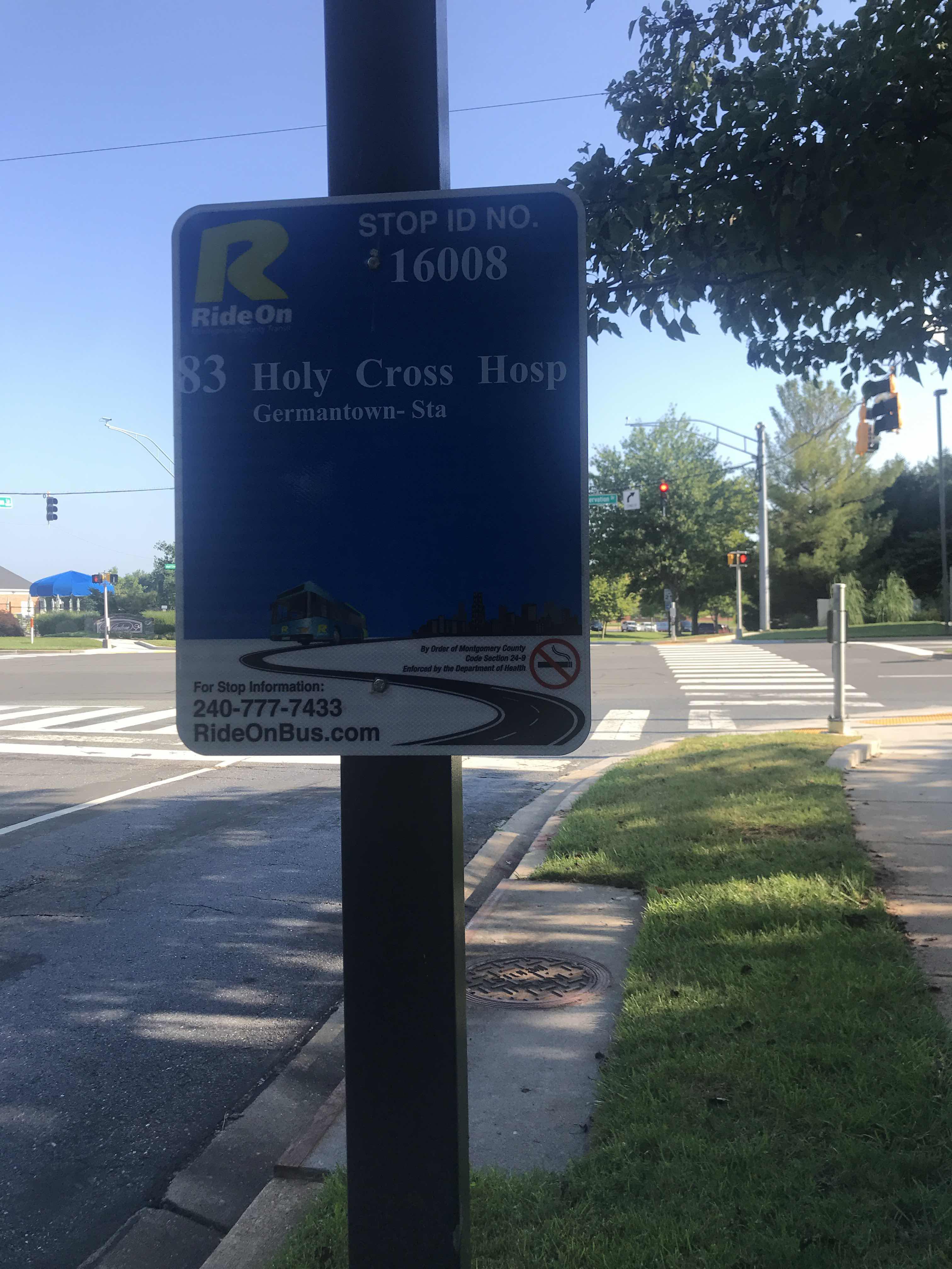
Milestone Center Dr & Observation Dr stop’s code is 16008
The first line to this stop is 83, at 7:09 AM, and the last line is 83 at 10:01 PM.
12537 Great Park Cir, Germantown, MD, USA
This stop serves Montgomery County Ride On’s lines
- Dorsey Mill Rd & Observation Dr,
- Ridge Rd & Observation Dr,
- Seneca Meadows Pkwy & the Shops
Bus stops near Milestone Center Dr & Observation Dr stop
- Germantown
Train station near Milestone Center Dr & Observation Dr station
- Laurel Race Track,
- Rhode Island Av Nw+1 St NW,
- Harford Ave & Putty Hill Ave Sb,
- Sunset Hills Rd @ Reston Pkwy W,
- Washington Blvd & Monroe St Wb,
- 2nd St & E Capitol St (Supreme Court) Sb,
- Metro Dr & Seton Dr,
- Old Washington Rd & Sub Station Rd,
- Georgia Av+Seminary Rd,
- Seabrook,
- Rock Spring Dr & Rockledge Dr,
- Marlboro Pk+Delano Ln,
- Chevy Chase Terminal+Connecticut Av NW,
- Federal Drug Administration Fda &,
- Leesburg Pk+Baileys Crossroads Ctr,
- Ft Totten Station & Bus Bay E, F, G,
- Medical Center Dr & @9711,
- Pennsylvania Av Se+L'Enfant Sq SE,
- East West Hwy & @1325,
- Western Av+Westmoreland Cir
Popular public transit stations in Montgomery County
Get around Montgomery County by public transit!
Traveling around Montgomery County has never been so easy. See step by step directions as you travel to any attraction, street or major public transit station. View bus and train schedules, arrival times, service alerts and detailed routes on a map, so you know exactly how to get to anywhere in Montgomery County.
When traveling to any destination around Montgomery County use Moovit's Live Directions with Get Off Notifications to know exactly where and how far to walk, how long to wait for your line, and how many stops are left. Moovit will alert you when it's time to get off — no need to constantly re-check whether yours is the next stop.
Wondering how to use public transit in Montgomery County or how to pay for public transit in Montgomery County? Moovit public transit app can help you navigate your way with public transit easily, and at minimum cost. It includes public transit fees, ticket prices, and costs. Looking for a map of Montgomery County public transit lines? Moovit public transit app shows all public transit maps in Montgomery County with all Bus, Train, Metro, Light Rail and Ferry routes and stops on an interactive map.
Washington, D.C. - Baltimore, MD has 5 transit type(s), including: Bus, Train, Metro, Light Rail and Ferry, operated by several transit agencies, including WMATA, Montgomery County Ride On, Fairfax Connector, TheBus, PRTC, DASH - Alexandria, Arlington Transit (ART), DC Streetcar, RTA of Central Maryland, FXBGO!, MDOT MTA, Marc, Virginia Railway Express (VRE), University of Maryland Shuttle-UM and CUE Bus - City of Fairfax