How to get to Modicare by bus?
Click on the bus route to see step by step directions with maps, line arrival times and updated time schedules.
From Jevargi - Chamarajanagar Road, Mysuru
51 minFrom Jayadeva Hospital, Mysuru
30 minFrom Rajiv Nagar 1st Stage, Mysuru
62 minFrom Esi Hospital, Mysuru
34 minFrom Public Toilet, Mysuru
51 minFrom Mahajana High School, Mysuru
31 minFrom JSS Layout 2nd Stage, Mysuru
60 minFrom Sukhadayi Layout-Stage-2, Mysuru
65 minFrom Banni Mantapa, Mysuru
51 minFrom Sathagalli, Mysuru
49 min
How to get to Modicare by train?
Click on the train route to see step by step directions with maps, line arrival times and updated time schedules.
Bus stops near Modicare in Mysuru
- Vivekananda Circle (ವಿವೇಕಾನಂದ ವೃತ್ತ), 3 min walk,VIEW
- Kuvempu Nagar Bus Stand (ಕುವೆಂಪುನಗರ ಬಸ್ ನಿಲ್ದಾಣ), 5 min walk,VIEW
- Ruby Bakery (ರೂಬಿ ಬೇಕರಿ), 6 min walk,VIEW
- Sri Rampura Water Tank (ಶ್ರೀ ರಾಮ್ಪುರ ವಾಟರ್ ಟ್ಯಾಂಕ್), 7 min walk,VIEW
- Kuvempu Nagar Depot (ಕುವೆಂಪುನಗರ ಘಟಕ), 8 min walk,VIEW
- Eshwara Temple (ಈಶ್ವರ ದೇವಸ್ಥಾನ), 9 min walk,VIEW
Train station near Modicare in Mysuru
- Chamarajapuram, 36 min walk,VIEW
Bus lines to Modicare in Mysuru
- 53, City Bus Station ⇄ B.E.M.L Nagar (ನಗರ ಬಸ್ ನಿಲ್ದಾಣ ⇄ ಬಿ.ಇ.ಎಂ.ಎಲ್ ನಗರ),VIEW
- 72, Metagalli ⇄ B.E.M.L Nagar (ಮೆಟಗಳ್ಳಿ ⇄ ಬಿ.ಇ.ಎಂ.ಎಲ್ ನಗರ),VIEW
- 73, City Bus Station ⇄ B.E.M.L Nagar (ನಗರ ಬಸ್ ನಿಲ್ದಾಣ ⇄ ಬಿ.ಇ.ಎಂ.ಎಲ್ ನಗರ),VIEW
- 83, City Bus Station ⇄ B.E.M.L Nagar (ನಗರ ಬಸ್ ನಿಲ್ದಾಣ ⇄ ಬಿ.ಇ.ಎಂ.ಎಲ್ ನಗರ),VIEW
- 94, City Bus Station ⇄ B.E.M.L Nagar (ನಗರ ಬಸ್ ನಿಲ್ದಾಣ ⇄ ಬಿ.ಇ.ಎಂ.ಎಲ್ ನಗರ),VIEW
- 80A, City Bus Station ⇄ B.E.M.L Nagar (ನಗರ ಬಸ್ ನಿಲ್ದಾಣ ⇄ ಬಿ.ಇ.ಎಂ.ಎಲ್ ನಗರ),VIEW
- 94A, City Bus Station ⇄ Parasaiahna Hundi (ನಗರ ಬಸ್ ನಿಲ್ದಾಣ ⇄ ಪರಸಯ್ಯನಹುಂಡಿ),VIEW
- 80B, B.E.M.L Nagar ⇄ Yaraganahalli (ಬಿ.ಇ.ಎಂ.ಎಲ್ ನಗರ ⇄ ಎರಗನಹಳ್ಳಿ),VIEW
- 94B, City Bus Station ⇄ Lingambudhi Palya (ನಗರ ಬಸ್ ನಿಲ್ದಾಣ ⇄ ಲಿಂಗಂಬುಧಿ ಪಾಳ್ಯ),VIEW
- 80BN, B.E.M.L Nagar ➥ City Bus Station (ಬಿ.ಇ.ಎಂ.ಎಲ್ ನಗರ ➥ ನಗರ ಬಸ್ ನಿಲ್ದಾಣ),VIEW
- 178D, Parasaiahna Hundi ⇄ Narayana Hrudayalaya (ಪರಸಯ್ಯನ ಹುಂಡಿ ⇄ ನಾರಾಯಣ ಹೃದಯಾಲಯ),VIEW
- 178DB, B.E.M.L Nagar ⇄ Narayana Hrudayalaya (ಬಿ.ಇ.ಎಂ.ಎಲ್ ನಗರ ⇄ ನಾರಾಯಣ ಹೃದಯಾಲಯ),VIEW
- 94DC, City Bus Station ⇄ Parasaiahna Hundi (ನಗರ ಬಸ್ ನಿಲ್ಧಾಣ ⇄ ಪರಸಯ್ಯನಹುಂಡಿ),VIEW
- 94E, B.E.M.L Nagar ⇄ Sathagalli (ಬಿ.ಇ.ಎಂ.ಎಲ್ ನಗರ ⇄ ಸಾತಗಳ್ಳಿ),VIEW
- 116E, LnT ⇄ B.E.M.L Nagar (ಎಲ್&ಟಿ ⇄ ಬಿ.ಇ.ಎಂ.ಎಲ್ ನಗರ),VIEW
- 135N, City Bus Station ⇄ Kuvempu Nagar (ನಗರ ಬಸ್ ನಿಲ್ದಾಣ ⇄ ಕುವೆಂಪುನಗರ),VIEW
- 2R, City Bus Station ⇄ B.E.M.L Nagar (ನಗರ ಬಸ್ ನಿಲ್ದಾಣ ⇄ ಬಿ.ಇ.ಎಂ.ಎಲ್ ನಗರ),VIEW
- 53R, City Bus Station ⇄ B.E.M.L Nagar (ನಗರ ಬಸ್ ನಿಲ್ದಾಣ ⇄ ಬಿ.ಇ.ಎಂ.ಎಲ್ ನಗರ),VIEW
- 60R, City Bus Station ↺ City Bus Station (ನ.ಬ.ನಿ ↺ ನ.ಬ.ನಿ),VIEW
- 116R, Rangsons ⇄ B.E.M.L Nagar (ರ್ಯಾಂಗ್ಸನ್ಸ್ ⇄ ಬಿ.ಇ.ಎಂ.ಎಲ್ ನಗರ),VIEW
What are the closest stations to Modicare?
The closest stations to Modicare are:
- Vivekananda Circle (ವಿವೇಕಾನಂದ ವೃತ್ತ) is 158 meters away, 3 min walk.
- Kuvempu Nagar Bus Stand (ಕುವೆಂಪುನಗರ ಬಸ್ ನಿಲ್ದಾಣ) is 318 meters away, 5 min walk.
- Ruby Bakery (ರೂಬಿ ಬೇಕರಿ) is 450 meters away, 6 min walk.
- Kuvempu Nagar Depot (ಕುವೆಂಪುನಗರ ಘಟಕ) is 514 meters away, 8 min walk.
- Sri Rampura Water Tank (ಶ್ರೀ ರಾಮ್ಪುರ ವಾಟರ್ ಟ್ಯಾಂಕ್) is 528 meters away, 7 min walk.
- Eshwara Temple (ಈಶ್ವರ ದೇವಸ್ಥಾನ) is 636 meters away, 9 min walk.
- Chamarajapuram is 2807 meters away, 36 min walk.
Which bus lines stop near Modicare?
These bus lines stop near Modicare: 135, 53R, 72, 80, 80B.
Which train line stops near Modicare?
SWR (Nanjangud Town)
What’s the nearest bus station to Modicare in Mysuru?
The nearest bus station to Modicare in Mysuru is Vivekananda Circle (ವಿವೇಕಾನಂದ ವೃತ್ತ). It’s a 3 min walk away.
What time is the first train to Modicare in Mysuru?
The SWR is the first train that goes to Modicare in Mysuru. It stops nearby at 9:15 AM.
What time is the last train to Modicare in Mysuru?
The SWR is the last train that goes to Modicare in Mysuru. It stops nearby at 11:21 AM.
What time is the first bus to Modicare in Mysuru?
The 2R is the first bus that goes to Modicare in Mysuru. It stops nearby at 4:43 AM.
What time is the last bus to Modicare in Mysuru?
The 80N is the last bus that goes to Modicare in Mysuru. It stops nearby at 10:48 PM.
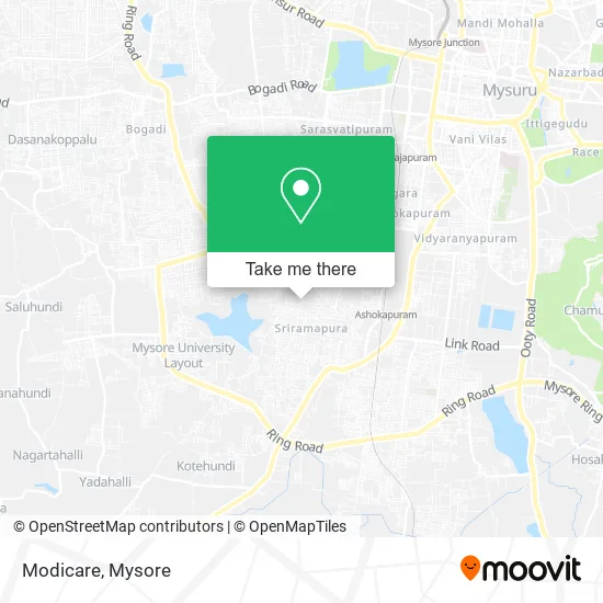
See Modicare, Mysuru, on the map
Public Transit to Modicare in Mysuru
Wondering how to get to Modicare in Mysuru? Moovit helps you find the best way to get to Modicare with step-by-step directions from the nearest public transit station.
Moovit provides free maps and live directions to help you navigate through your city. View schedules, routes, timetables, and find out how long does it take to get to Modicare in real time.
Looking for the nearest stop or station to Modicare? Check out this list of stops closest to your destination: Vivekananda Circle (ವಿವೇಕಾನಂದ ವೃತ್ತ); Kuvempu Nagar Bus Stand (ಕುವೆಂಪುನಗರ ಬಸ್ ನಿಲ್ದಾಣ); Ruby Bakery (ರೂಬಿ ಬೇಕರಿ); Kuvempu Nagar Depot (ಕುವೆಂಪುನಗರ ಘಟಕ); Sri Rampura Water Tank (ಶ್ರೀ ರಾಮ್ಪುರ ವಾಟರ್ ಟ್ಯಾಂಕ್); Eshwara Temple (ಈಶ್ವರ ದೇವಸ್ಥಾನ); Chamarajapuram.
Bus: 135, 53R, 72, 80, 80B, 53, 73, 83, 94, 80N, 94N, 135NN, 94C, 61, 62, 62A, 62K, 62R, 60, 60A.Train: SWR.
Want to see if there’s another route that gets you there at an earlier time? Moovit helps you find alternative routes or times. Get directions from and directions to Modicare easily from the Moovit App or Website.
We make riding to Modicare easy, which is why over 1.5 million users, including users in Mysuru, trust Moovit as the best app for public transit. You don’t need to download an individual bus app or train app, Moovit is your all-in-one transit app that helps you find the best bus time or train time available.
For information on prices of bus and train, costs and ride fares to Modicare, please check the Moovit app.
Use the app to navigate to popular places including to the airport, hospital, stadium, grocery store, mall, coffee shop, school, college, and university.
Modicare Address: 5th Main Road Mysuru 570023 KA street in Mysuru
- Manvi Tea & Juice Corner,
- Iyengars Condiments,
- Kuvempunagar Bus Depot,
- N S Madina Motors,
- Mahalakshmi Honda Bike Zone,
- Suddha Kudiyuva Neerina Ghataka,
- Saaryas Aeshtetics,
- Rajshree Jewellers & Bankers,
- Raj Shri Jewellers,
- Graviti Events,
- Prashanth Enterprises,
- Amrutha Chinese,
- Wood Workshop,
- Balaji Service Centre,
- Harsh Jewels & Bankers,
- Sudha Clinic,
- Uma Maheshwara Traders - Acc,
- Saibaba Tent House,
- Vinayaka Bankers & Jewellers,
- Meenakshi Fancy & Gift Center
Places Near Modicare (Mysuru)
- Dattagalli, Mysuru,
- Vidya Vardhaka College Of Engineering, Mysuru,
- Jayadeva Hospital, Mysuru,
- Red Light area, Mysuru,
- Payana Car Museum, Shrirangapattana,
- Venugopal Swamy Temple, Mysuru,
- Hebbal Industrial Area, Mysuru,
- Brindavan Garden KRS Mysore, Mysuru,
- Ranganathittu Bird Sanctuary, Shrirangapattana,
- Venugopala Swamy Temple (Shri Venugopala Swamy Temple-Kannambady), Pandavapura,
- Sri Chamundeshwari Temple, Mysuru,
- Iskcon Mysore, Mysuru,
- Nimishamba Temple, Shrirangapattana,
- Bharat Cancer Hospital Bus Stop, Mysuru,
- Vijayanagar 4th Stage, Mysuru,
- Brindavan Garden KRS Mysore, Pandavapura,
- Chamundi Hill, Mysuru,
- Kallahalli, Mysuru,
- KRS Dam, Pandavapura,
- Ion Digital Zone, Mysuru
How to get to popular places in Mysore with public transit
Get around Mysuru by public transit!
Traveling around Mysuru has never been so easy. See step by step directions as you travel to any attraction, street or major public transit station. View bus and train schedules, arrival times, service alerts and detailed routes on a map, so you know exactly how to get to anywhere in Mysuru.
When traveling to any destination around Mysuru use Moovit's Live Directions with Get Off Notifications to know exactly where and how far to walk, how long to wait for your line, and how many stops are left. Moovit will alert you when it's time to get off — no need to constantly re-check whether yours is the next stop.
Wondering how to use public transit in Mysuru or how to pay for public transit in Mysuru? Moovit public transit app can help you navigate your way with public transit easily, and at minimum cost. It includes public transit fees, ticket prices, and costs. Looking for a map of Mysuru public transit lines? Moovit public transit app shows all public transit maps in Mysuru with all Bus and Train routes and stops on an interactive map.
Mysore has 2 transit type(s), including: Bus and Train, operated by several transit agencies, including KSRTC AC Volvo Bus Services, KSRTC Ordinary Bus Services and South-Western Railways
Public transit lines with stations closest to Modicare in Mysuru
Train lines with stations closest to Modicare in Mysuru
Bus lines with stations closest to Modicare in Mysuru
Vivekananda Circle (ವಿವೇಕಾನಂದ ವೃತ್ತ)
 53City Bus Station ⇄ B.E.M.L Nagar (ನಗರ ಬಸ್ ನಿಲ್ದಾಣ ⇄ ಬಿ.ಇ.ಎಂ.ಎಲ್ ನಗರ)
- 72Metagalli ⇄ B.E.M.L Nagar (ಮೆಟಗಳ್ಳಿ ⇄ ಬಿ.ಇ.ಎಂ.ಎಲ್ ನಗರ)
- 73City Bus Station ⇄ B.E.M.L Nagar (ನಗರ ಬಸ್ ನಿಲ್ದಾಣ ⇄ ಬಿ.ಇ.ಎಂ.ಎಲ್ ನಗರ)
- 83City Bus Station ⇄ B.E.M.L Nagar (ನಗರ ಬಸ್ ನಿಲ್ದಾಣ ⇄ ಬಿ.ಇ.ಎಂ.ಎಲ್ ನಗರ)
- 94City Bus Station ⇄ B.E.M.L Nagar (ನಗರ ಬಸ್ ನಿಲ್ದಾಣ ⇄ ಬಿ.ಇ.ಎಂ.ಎಲ್ ನಗರ)
Vivekananda Circle (ವಿವೇಕಾನಂದ ವೃತ್ತ)
- 80Vivekananda Circle ⇄ Sathagalli (ವಿವೇಕಾನಂದ ವೃತ್ತ ⇄ ಸಾತಗಳ್ಳಿ)
- 135City Bus Station ↺ City Bus Station (ನ.ಬ.ನಿ ↺ ನ,ಬ,ನಿ)
- 80NCity Bus Station ⇄ Vivekananda Circle (ನಗರ ಬಸ್ ನಿಲ್ದಾಣ ⇄ ವಿವೇಕಾನಂದ ವೃತ್ತ)
- 94NCity Bus Station ⇄ Vivekananda Circle (ನಗರ ಬಸ್ ನಿಲ್ದಾಣ ⇄ ವಿವೇಕಾನಂದ ವೃತ್ತ)
- 135NNVivekananda Circle ➥ City Bus Station (ವಿವೇಕಾನಂದ ವೃತ್ತ ➥ ನ.ಬ.ನಿ)
Ruby Bakery (ರೂಬಿ ಬೇಕರಿ)
- 61City Bus Station ⇄ Ramakrishna Nagar H Block (ನಗರ ಬಸ್ ನಿಲ್ದಾಣ ⇄ ರಾಮಕೃಷ್ಣ ನಗರ ಹೆಚ್ ಬ್ಲಾಕ್)
- 62City Bus Station ⇄ Ramakrishna Nagar H Block (ನಗರ ಬಸ್ ನಿಲ್ದಾಣ ⇄ ರಾಮಕೃಷ್ಣ ನಗರ ಹೆಚ್ ಬ್ಲಾಕ್)
- 62ACity Bus Station ⇄ Ramakrishna Nagar H Block (ನಗರ ಬಸ್ ನಿಲ್ದಾಣ ⇄ ರಾಮಕೃಷ್ಣ ನಗರ ಹೆಚ್ ಬ್ಲಾಕ್)
- 62KCity Bus Station ⇄ Ramakrishna Nagar H Block (ನಗರ ಬಸ್ ನಿಲ್ದಾಣ ⇄ ರಾಮಕೃಷ್ಣ ನಗರ ಹೆಚ್ ಬ್ಲಾಕ್)
- 62RCity Bus Station ⇄ Ramakrishna Nagar H Block (ನಗರ ಬಸ್ ನಿಲ್ದಾಣ ⇄ ರಾಮಕೃಷ್ಣ ನಗರ ಹೆಚ್ ಬ್ಲಾಕ್)