How to get to Multibanco by bus?
Click on the bus route to see step by step directions with maps, line arrival times and updated time schedules.
From Universidade do Minho - Campus de Azurém/Guimarães, Guimarães
76 minFrom Hospital de Famalicão - Centro Hospitalar Médio Ave, Vila Nova de Famalicão e Calendário
41 minFrom Avepark, Guimarães
48 minFrom Rebordões, Santo Tirso
98 minFrom Moreira de Conegos, Guimarães
75 minFrom Campus de Azurém, Guimarães
76 minFrom Santo Tirso, Santo Tirso, Couto (Santa Cristina e São Miguel) e Burgães
106 minFrom Guimarães Shopping, Guimarães
56 minFrom Vila Nova de Famalicão, Vila Nova de Famalicão e Calendário
37 minFrom Parque Aquático Scorpio, Candoso (São Tiago) e Mascotelos
91 min
Bus stops near Multibanco in Oliveira (Santa Maria)
Bus lines to Multibanco in Oliveira (Santa Maria)
What are the closest stations to Multibanco?
The closest stations to Multibanco are:
- Anjos / Verdes is 16 meters away, 1 min walk.
- Bouças is 659 meters away, 9 min walk.
Which bus lines stop near Multibanco?
These bus lines stop near Multibanco: 081, 159, 164, 3773, 3775.
What’s the nearest bus station to Multibanco in Oliveira (Santa Maria)?
The nearest bus station to Multibanco in Oliveira (Santa Maria) is Anjos / Verdes. It’s a 1 min walk away.
What time is the first bus to Multibanco in Oliveira (Santa Maria)?
The 3773 is the first bus that goes to Multibanco in Oliveira (Santa Maria). It stops nearby at 8:11 AM.
What time is the last bus to Multibanco in Oliveira (Santa Maria)?
The 3773 is the last bus that goes to Multibanco in Oliveira (Santa Maria). It stops nearby at 7:48 PM.
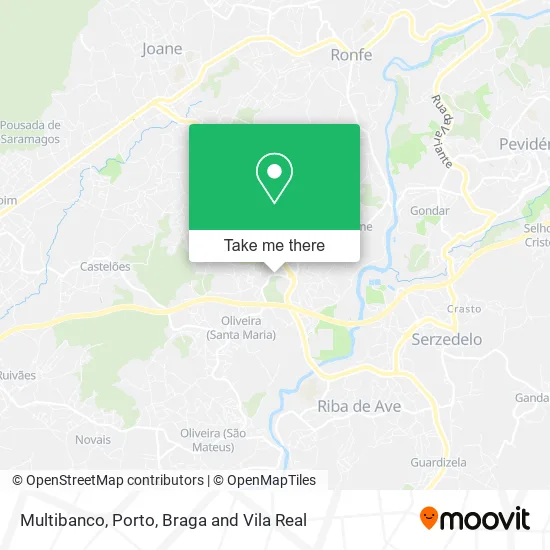
See Multibanco, Oliveira (Santa Maria), on the map
Public Transit to Multibanco in Oliveira (Santa Maria)
Wondering how to get to Multibanco in Oliveira (Santa Maria)? Moovit helps you find the best way to get to Multibanco with step-by-step directions from the nearest public transit station.
Moovit provides free maps and live directions to help you navigate through your city. View schedules, routes, timetables, and find out how long does it take to get to Multibanco in real time.
Looking for the nearest stop or station to Multibanco? Check out this list of stops closest to your destination: Anjos / Verdes; Bouças.
Bus: 081, 159, 164, 3773, 3775, 354, 453, 455, 450.
Want to see if there’s another route that gets you there at an earlier time? Moovit helps you find alternative routes or times. Get directions from and directions to Multibanco easily from the Moovit App or Website.
We make riding to Multibanco easy, which is why over 1.5 million users, including users in Oliveira (Santa Maria), trust Moovit as the best app for public transit. You don’t need to download an individual bus app or train app, Moovit is your all-in-one transit app that helps you find the best bus time or train time available.
For information on prices of bus, costs and ride fares to Multibanco, please check the Moovit app.
Use the app to navigate to popular places including to the airport, hospital, stadium, grocery store, mall, coffee shop, school, college, and university.
Multibanco Address: Avenida Humberto Delgado Anjos, 4765-803 Vila Nova de Famalicão street in Oliveira (Santa Maria)
- SOCIEDADE INTERBANCARIA DE SERVICOS S A SIBS,
- Ribaltas Club,
- Ourivesaria Millenium,
- Onda Curiosa,
- Humanitave- Associação de Emergência Humanitária,
- Maria C Faria Cunha,
- Risco Invisível - Carpintaria,
- Francisco & Rafael S.a.,
- Construções - Machado & Angélica,
- Escola Basica 1, 2, 3 de Pedome,
- Multibanco,
- Pinscher,
- Centro Social de Castelões polo de Pedome,
- Portela e Irmão,
- Beatriz & Alexandre-Fishtrading,
- Snack Bar Tal Sítio,
- Jardim de Infância do Centro Social da Paróquia de Castelões,
- Cemitério de Pedome,
- Sempre Kontigo,
- Casa de Pasto Tonicha
Places Near Multibanco (Oliveira (Santa Maria))
- VILA do CONDE PORTO FASHION OUTLET, Modivas,
- MAR Shopping, Matosinhos e Leça da Palmeira,
- Acesso ao Shopping Parque Nascente, Campanhã,
- Avintes, Vila Nova De Gaia,
- Hospital Santos Silva, Vila Nova De Gaia,
- Zoo Santo Inácio, Vila Nova De Gaia,
- Espinho, Espinho,
- Parque Aquatico Amarante - Aqua Aventura, Amarante,
- Valongo, Valongo,
- El Corte Inglés de Gaia, Mafamude e Vilar do Paraíso,
- Estádio do Dragão, Campanhã,
- Hospital da Prelada, Ramalde,
- Senhor de Matosinhos, Matosinhos e Leça da Palmeira,
- Rua Calouste Gulbenkian, Lordelo do Ouro e Massarelos,
- Canidelo, Vila Nova De Gaia,
- Palácio de Cristal, Lordelo do Ouro e Massarelos,
- Maia, Maia,
- Arrábida Shopping, Santa Marinha e São Pedro da Afurada,
- Leça da Palmeira, Matosinhos e Leça da Palmeira,
- Hospital de Santo António, Cedofeita, Santo Ildefonso, Sé, Miragaia, São Nicolau e Vitória
How to get to popular places in Porto, Braga and Vila Real with public transit
Get around Oliveira (Santa Maria) by public transit!
Traveling around Oliveira (Santa Maria) has never been so easy. See step by step directions as you travel to any attraction, street or major public transit station. View bus and train schedules, arrival times, service alerts and detailed routes on a map, so you know exactly how to get to anywhere in Oliveira (Santa Maria).
When traveling to any destination around Oliveira (Santa Maria) use Moovit's Live Directions with Get Off Notifications to know exactly where and how far to walk, how long to wait for your line, and how many stops are left. Moovit will alert you when it's time to get off — no need to constantly re-check whether yours is the next stop.
Wondering how to use public transit in Oliveira (Santa Maria) or how to pay for public transit in Oliveira (Santa Maria)? Moovit public transit app can help you navigate your way with public transit easily, and at minimum cost. It includes public transit fees, ticket prices, and costs. Looking for a map of Oliveira (Santa Maria) public transit lines? Moovit public transit app shows all public transit maps in Oliveira (Santa Maria) with all Bus, Train, Metro, Ferry, Funicular and Gondola routes and stops on an interactive map.
Porto, Braga and Vila Real has 6 transit type(s), including: Bus, Train, Metro, Ferry, Funicular and Gondola, operated by several transit agencies, including Metro do Porto, Metro do Porto - Metrobus, CP - Comboios de Portugal, STCP, UNIR Mobilidade da Area Metropolitana do Porto, Getbus - Aerobus, Mobiave, Valpibus, TUB - Transportes Urbanos de Braga, TuViana, Guimabus, Ave Mobilidade, Cávado Mobilidade, Transdev and Câmara Municipal de Santo Tirso
Public transit lines with stations closest to Multibanco in Oliveira (Santa Maria)
Bus lines with stations closest to Multibanco in Oliveira (Santa Maria)
Anjos / Verdes
 164Pedome (Ponte de Serves) - Famalicão (Terminal) (via Castelões)
- 354Riba de Ave (Igreja) - Joane (Escola Bernardino Machado) (via Pedome)
- 453Carreira (Fojo) - Joane (Escola Bernardino Machado) (via Pedome)
- 455Delães (Pedro Marques) - Pedome (Escola) (via Ruivães)
- 3773Guimarães (Terminal) - Famalicão (Terminal) (via Ruivães)