Ne 10 Av & Ne 177 St stop - Monday schedule
| Line | Direction | Time |
|---|---|---|
| 9 | 9 - Downtown Miami Via M. Gardens Dr | 6:23 AM |
| 9 | 9 - Downtown Miami Via M. Gardens Dr | 6:43 AM |
| 9 | 9 - Downtown Miami Via M. Gardens Dr | 7:00 AM |
| 9 | 9 - Downtown Miami Via M. Gardens Dr | 7:21 AM |
| 9 | 9 - Downtown Miami Via M. Gardens Dr | 7:40 AM |
| 9 | 9 - Downtown Miami Via M. Gardens Dr | 7:59 AM |
| 9 | 9 - Downtown Miami Via M. Gardens Dr | 8:18 AM |
| 9 | 9 - Downtown Miami Via M. Gardens Dr | 8:43 AM |
| 9 | 9 - Downtown Miami Via M. Gardens Dr | 9:14 AM |
| 9 | 9 - Downtown Miami Via M. Gardens Dr | 9:42 AM |
| 9 | 9 - Downtown Miami Via M. Gardens Dr | 10:12 AM |
| 9 | 9 - Downtown Miami Via M. Gardens Dr | 10:41 AM |
| 9 | 9 - Downtown Miami Via M. Gardens Dr | 11:08 AM |
| 9 | 9 - Downtown Miami Via M. Gardens Dr | 11:36 AM |
| 9 | 9 - Downtown Miami Via M. Gardens Dr | 12:00 PM |
| 9 | 9 - Downtown Miami Via M. Gardens Dr | 12:30 PM |
| 9 | 9 - Downtown Miami Via M. Gardens Dr | 1:01 PM |
| 9 | 9 - Downtown Miami Via M. Gardens Dr | 1:35 PM |
| 9 | 9 - Downtown Miami Via M. Gardens Dr | 2:01 PM |
| 9 | 9 - Downtown Miami Via M. Gardens Dr | 2:21 PM |
| 9 | 9 - Downtown Miami Via M. Gardens Dr | 2:47 PM |
| 9 | 9 - Downtown Miami Via M. Gardens Dr | 3:07 PM |
| 9 | 9 - Downtown Miami Via M. Gardens Dr | 3:26 PM |
| 9 | 9 - Downtown Miami Via M. Gardens Dr | 3:46 PM |
| 9 | 9 - Downtown Miami Via M. Gardens Dr | 4:12 PM |
Directions to Ne 10 Av & Ne 177 St stop (Miami) with public transit
The following transit lines have routes that pass near Ne 10 Av & Ne 177 St
 Bus: 9, NMBEACD, 95, 183, 17.
How to get to Ne 10 Av & Ne 177 St stop by bus?
Click on the bus route to see step by step directions with maps, line arrival times and updated time schedules.
Bus stops near Ne 10 Av & Ne 177 St stop in Miami
- Ne 10 Av & Ne 175 St, 3 min walk,
- Ne 183 St & Ne 10 Av, 8 min walk,
- Ne 6 Av & Ne 177 St, 11 min walk,
- Ne 171st St @ Ne 8th Ave, 15 min walk,
Bus lines to Ne 10 Av & Ne 177 St stop in Miami
- 9, 9 - Downtown Miami Via M. Gardens Dr,
- 95, 95a - Aventura Mall Terminal Via Golden Glades Park & Ride,
- 183, 183 - Okeechobee Station,
- 17, 17 - Vizcaya Station,
- NMBEACD, City Of North Miami Beach D Route,
What are the closest stations to Ne 10 Av & Ne 177 St?
The closest stations to Ne 10 Av & Ne 177 St are:
- Ne 10 Av & Ne 175 St stop is 183 yards away, 3 min walk.
- Ne 183 St & Ne 10 Av stop is 657 yards away, 8 min walk.
- Ne 6 Av & Ne 177 St stop is 904 yards away, 11 min walk.
- Ne 171st St @ Ne 8th Ave stop is 1222 yards away, 15 min walk.
Which bus lines stop near Ne 10 Av & Ne 177 St?
These bus lines stop near Ne 10 Av & Ne 177 St: 9, NMBEACD.
What’s the nearest bus station to Ne 10 Av & Ne 177 St in Miami?
The nearest bus station to Ne 10 Av & Ne 177 St in Miami is Ne 10 Av & Ne 175 St. It’s a 3 min walk away.
What time is the first bus to Ne 10 Av & Ne 177 St in Miami?
The 17 is the first bus that goes to Ne 10 Av & Ne 177 St in Miami. It stops nearby at 3:37 AM.
What time is the last bus to Ne 10 Av & Ne 177 St in Miami?
The 9 is the last bus that goes to Ne 10 Av & Ne 177 St in Miami. It stops nearby at 12:38 AM.
Ne 10 Av & Ne 177 St station
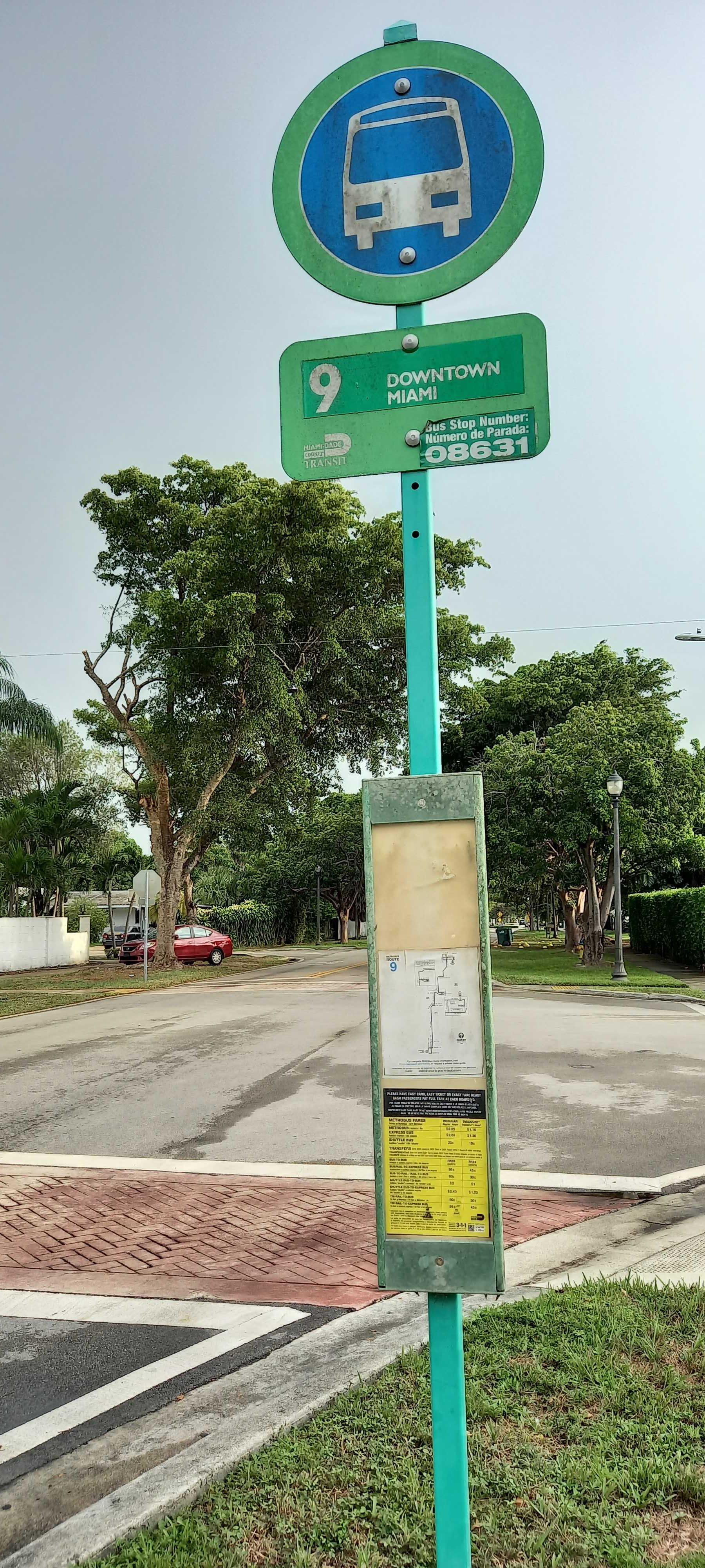 Taken by Anonymous
See Ne 10 Av & Ne 177 St stop, Miami, on the map
Public transit to Ne 10 Av & Ne 177 St stop (ID: A10V1773) in Miami
Looking for directions to Ne 10 Av & Ne 177 St in Miami, United States?
Download the Moovit App to find the current schedule and step-by-step directions for Bus routes that pass through Ne 10 Av & Ne 177 St.
Looking for the nearest stops closest to Ne 10 Av & Ne 177 St ? Check out this list of closest stops to your destination: Ne 10 Av & Ne 175 St; Ne 183 St & Ne 10 Av; Ne 6 Av & Ne 177 St; Ne 171st St @ Ne 8th Ave.
Bus: 9, NMBEACD, 95, 183, 17.
We make riding on public transit to Ne 10 Av & Ne 177 St easy, which is why over 1.7 billion users, including users in Miami trust Moovit as the best app for public transit.
Use the app to navigate to popular places including to the airport, hospital, stadium, grocery store, mall, coffee shop, school, college, and university.
Ne 10 Av & Ne 177 St stop’s code is A10V1773
The first line to this stop is 9, at 6:23 AM, and the last line is 9 at 12:30 AM.
17700 Ne 10th Ave, Ives Estates, FL, USA
This stop serves Miami-Dade Transit’s lines
- Ne 10 Av & Ne 175 St,
- Ne 183 St & Ne 10 Av,
- Ne 6 Av & Ne 177 St,
- Ne 171st St @ Ne 8th Ave
Bus stops near Ne 10 Av & Ne 177 St stop
- Allapattah Station @ 3501 Nw 12 Av,
- US 441/Stirling Road (North) - (Seminole Way),
- Mile Marker 87 Tavrnier,
- Pembroke Road/US 441 (East),
- University,
- Collins Av & 4500 Blk,
- Ives Dairy Rd (Ne 199 St) & California Dr,
- JOG RD at SOUTHERN BLVD,
- Copans Road/Powerline Road,
- Indian Creek Dr & 40 St,
- Edgewater Dr @ # 90,
- Sw 42 Av & Coral Way,
- US 441/Northwest 41st Street,
- Indian Creek Dr & 63 St,
- Historic Overtown/Lyric Theatre,
- Nw 57 Av & W Flagler St,
- Sw 112 Av @ Sw 220 St,
- Pine Island Road/Northwest 41st Street,
- FEDERAL HWY at NE 20TH ST,
- Sw 72 St @ Sw 147 Av
Popular public transit stations in Miami
Get around Miami by public transit!
Traveling around Miami has never been so easy. See step by step directions as you travel to any attraction, street or major public transit station. View bus and train schedules, arrival times, service alerts and detailed routes on a map, so you know exactly how to get to anywhere in Miami.
When traveling to any destination around Miami use Moovit's Live Directions with Get Off Notifications to know exactly where and how far to walk, how long to wait for your line, and how many stops are left. Moovit will alert you when it's time to get off — no need to constantly re-check whether yours is the next stop.
Wondering how to use public transit in Miami or how to pay for public transit in Miami? Moovit public transit app can help you navigate your way with public transit easily, and at minimum cost. It includes public transit fees, ticket prices, and costs. Looking for a map of Miami public transit lines? Moovit public transit app shows all public transit maps in Miami with all Bus, Train, Light Rail and Ferry routes and stops on an interactive map.
Miami has 4 transit type(s), including: Bus, Train, Light Rail and Ferry, operated by several transit agencies, including Broward County Transit, Miami-Dade Transit, Metrorail, Palm Tran, Tri-Rail, Brightline, MARTY, City of Homestead Trolley, Key West Transit, Treasure Coast Connector, GoLine IRT, Amtrak, Greyhound-us, FlixBus-us and Aventura Express Shuttle Bus