Directions to Neptune Diner (Queens) with public transportation
The following transit lines have routes that pass near Neptune Diner
 Bus: M60-SBS, Q19, Q18, Q101.
- Train: LONG BEACH BRANCH, PORT WASHINGTON BRANCH, RONKONKOMA BRANCH.
- Subway: N, W, E, F, M.
How to get to Neptune Diner by bus?
Click on the bus route to see step by step directions with maps, line arrival times and updated time schedules.
From Queens Criminal Court, Queens
64 minFrom Hotel Riu Plaza New York Times Square, Manhattan
75 minFrom 90 Church St, Manhattan
86 minFrom 163-03 Horace Harding Expressway, Queens
55 minFrom Macy's (Macy's Herald Square), Manhattan
71 minFrom Pace University, Manhattan
81 minFrom Castle Hill, Bronx
68 minFrom Angelika Film Center, Manhattan
73 minFrom Stuyvesant High School, Manhattan
99 minFrom 1 PIER 76, Manhattan
67 min
How to get to Neptune Diner by train?
Click on the train route to see step by step directions with maps, line arrival times and updated time schedules.
How to get to Neptune Diner by subway?
Click on the subway route to see step by step directions with maps, line arrival times and updated time schedules.
From Queens Criminal Court, Queens
44 minFrom Hotel Riu Plaza New York Times Square, Manhattan
32 minFrom 90 Church St, Manhattan
42 minFrom Macy's (Macy's Herald Square), Manhattan
28 minFrom Pace University, Manhattan
38 minFrom Castle Hill, Bronx
62 minFrom Angelika Film Center, Manhattan
39 minFrom Stuyvesant High School, Manhattan
46 minFrom 1 PIER 76, Manhattan
41 min
Bus stops near Neptune Diner in Queens
Subway stations near Neptune Diner in Queens
Bus lines to Neptune Diner in Queens
What are the closest stations to Neptune Diner?
The closest stations to Neptune Diner are:
- Hoyt Av/31 St is 79 yards away, 2 min walk.
- Steinway St is 131 yards away, 2 min walk.
- 30 Av/31 St is 668 yards away, 9 min walk.
- Astoria-Ditmars Blvd is 689 yards away, 9 min walk.
- Steinway St/25 Av is 767 yards away, 10 min walk.
Which bus lines stop near Neptune Diner?
These bus lines stop near Neptune Diner: M60-SBS, Q19.
Which train lines stop near Neptune Diner?
These train lines stop near Neptune Diner: LONG BEACH BRANCH, PORT WASHINGTON BRANCH, RONKONKOMA BRANCH.
Which subway lines stop near Neptune Diner?
These subway lines stop near Neptune Diner: N, W.
What’s the nearest subway station to Neptune Diner in Queens?
The nearest subway station to Neptune Diner in Queens is Steinway St. It’s a 2 min walk away.
What’s the nearest bus station to Neptune Diner in Queens?
The nearest bus station to Neptune Diner in Queens is Hoyt Av/31 St. It’s a 2 min walk away.
What time is the first subway to Neptune Diner in Queens?
The N is the first subway that goes to Neptune Diner in Queens. It stops nearby at 3:01 AM.
What time is the last subway to Neptune Diner in Queens?
The N is the last subway that goes to Neptune Diner in Queens. It stops nearby at 4:25 AM.
What time is the first bus to Neptune Diner in Queens?
The Q101 is the first bus that goes to Neptune Diner in Queens. It stops nearby at 3:05 AM.
What time is the last bus to Neptune Diner in Queens?
The M60-SBS is the last bus that goes to Neptune Diner in Queens. It stops nearby at 3:16 AM.
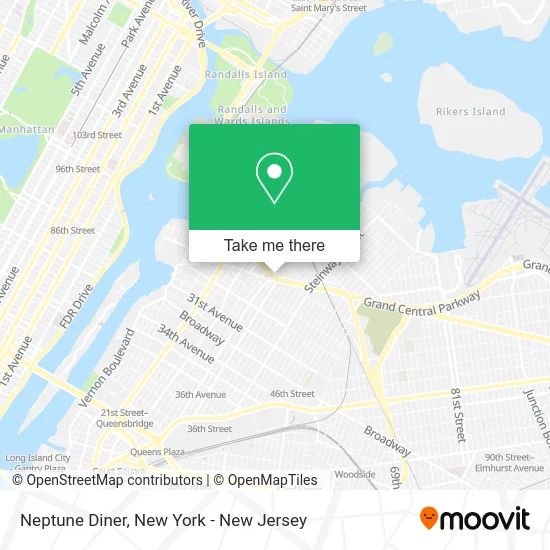
See Neptune Diner, Queens, on the map
Public Transit to Neptune Diner in Queens
Wondering how to get to Neptune Diner in Queens? Moovit helps you find the best way to get to Neptune Diner with step-by-step directions from the nearest public transit station.
Moovit provides free maps and live directions to help you navigate through your city. View schedules, routes, timetables, and find out how long does it take to get to Neptune Diner in real time.
Looking for the nearest stop or station to Neptune Diner? Check out this list of stops closest to your destination: Hoyt Av/31 St; Steinway St; 30 Av/31 St; Astoria-Ditmars Blvd; Steinway St/25 Av.
Bus: M60-SBS, Q19, Q18, Q101.Train: LONG BEACH BRANCH, PORT WASHINGTON BRANCH, RONKONKOMA BRANCH.Subway: N, W, E, F, M, R.
Want to see if there’s another route that gets you there at an earlier time? Moovit helps you find alternative routes or times. Get directions from and directions to Neptune Diner easily from the Moovit App or Website.
We make riding to Neptune Diner easy, which is why over 1.5 million users, including users in Queens, trust Moovit as the best app for public transit. You don’t need to download an individual bus app or train app, Moovit is your all-in-one transit app that helps you find the best bus time or train time available.
For information on prices of subway, bus and train, costs and ride fares to Neptune Diner, please check the Moovit app.
Use the app to navigate to popular places including to the airport, hospital, stadium, grocery store, mall, coffee shop, school, college, and university.
Neptune Diner Address: 31-05 Astoria Blvd (at 31st St) street in Queens
- Citi Bike - 31 St & Hoyt Ave N,
- 31st St (astoria blvd & 31st street),
- Astoria Blvd N (astoria blvd and 31st street),
- 31st St (I-278-TRUCK intersection 31st st),
- Christodoulos Iordanou,
- MTA Bus - M60 +Select Bus Service+,
- Ups Alliance Shipping Partner,
- 31st St (31st and Hoyt Ave S),
- Hoyt Ave S / 31st St,
- MTA M60, Q19 (Astoria Blvd / 31st St),
- MTA Bus - M60 (LaGuardia Airport) - Astoria Blvd @ 32nd,
- Astoria,
- H2 Environmental Pest Management,
- Sydney Health Xpres,
- Astoria Blvd Station,
- Ups Access Point Location,
- Party City,
- Functional Pro,
- Keyme Locksmiths,
- 33rd St (33rd street and astoria blvd)
Places Near Neptune Diner (Queens)
- 26 Federal Plaza, Manhattan,
- 1 Police Plaza, Manhattan,
- Chinatown, Manhattan,
- SoHo, Manhattan,
- Bellevue Hospital, Manhattan,
- qqqq, Manhattan,
- Rockefeller Center, Manhattan,
- Pier 83, Manhattan,
- Mountainside Hospital, Glen Ridge,
- 66 John Street, Manhattan,
- 911 Memorial, Manhattan,
- Hudson Yards, Manhattan,
- San Gennaro Feast, Manhattan,
- Times Square, Manhattan,
- Wall Street, Manhattan,
- 376 Hudson Street, Manhattan,
- Katz's Deli, Manhattan,
- Queens Center Mall, Queens,
- 111 Centre New York City Supreme Court, Manhattan,
- 3 Stone St, Manhattan
How to get to popular places in New York - New Jersey with public transit
Get around Queens by public transit!
Traveling around Queens has never been so easy. See step by step directions as you travel to any attraction, street or major public transit station. View bus and train schedules, arrival times, service alerts and detailed routes on a map, so you know exactly how to get to anywhere in Queens.
When traveling to any destination around Queens use Moovit's Live Directions with Get Off Notifications to know exactly where and how far to walk, how long to wait for your line, and how many stops are left. Moovit will alert you when it's time to get off — no need to constantly re-check whether yours is the next stop.
Wondering how to use public transit in Queens or how to pay for public transit in Queens? Moovit public transit app can help you navigate your way with public transit easily, and at minimum cost. It includes public transit fees, ticket prices, and costs. Looking for a map of Queens public transit lines? Moovit public transit app shows all public transit maps in Queens with all Bus, Train, Subway, Light Rail, Ferry and Cable Car routes and stops on an interactive map.
New York - New Jersey has 6 transit type(s), including: Bus, Train, Subway, Light Rail, Ferry and Cable Car, operated by several transit agencies, including MTA Subway, Metro-North Railroad, LIRR, PATH, MTA New York City Transit - Express routes, MTA Bus, NJ Transit, NYC Ferry, NICE bus, Bee-Line Bus, NJ Transit Rail, Norwalk Transit District, Hartford Line, River Valley Transit and HART