Norwood Park stop - Wednesday schedule
| Line | Direction | Time |
|---|---|---|
| 44D | O'Connell Street | 6:44 AM |
| 11 | Phoenix Pk | 6:55 AM |
| 11 | Phoenix Pk | 7:15 AM |
| 44 | Dcu | 7:28 AM |
| 44D | O'Connell Street | 7:34 AM |
| 11 | Phoenix Pk | 7:35 AM |
| 44 | Dcu | 8:08 AM |
| 11 | Phoenix Pk | 8:08 AM |
| 11 | Phoenix Pk | 8:28 AM |
| 11 | Phoenix Pk | 8:48 AM |
| 11 | Phoenix Pk | 9:06 AM |
| 44 | Dcu | 9:12 AM |
| 11 | Phoenix Pk | 9:31 AM |
| 11 | Phoenix Pk | 9:56 AM |
| 11 | Phoenix Pk | 10:16 AM |
| 44 | Dcu | 10:17 AM |
| 11 | Phoenix Pk | 10:41 AM |
| 11 | Phoenix Pk | 11:01 AM |
| 44 | Dcu | 11:17 AM |
| 11 | Phoenix Pk | 11:21 AM |
| 11 | Phoenix Pk | 11:51 AM |
| 44 | Dcu | 12:18 PM |
| 11 | Phoenix Pk | 12:22 PM |
| 11 | Phoenix Pk | 12:52 PM |
| 44 | Dcu | 1:18 PM |
Directions to Norwood Park stop (Dublin) with public transit
The following transit lines have routes that pass near Norwood Park
 Bus: 11, 39A, 44, 7B, 44D.
- Train: DART, RAIL.
How to get to Norwood Park stop by bus?
Click on the bus route to see step by step directions with maps, line arrival times and updated time schedules.
How to get to Norwood Park stop by train?
Click on the train route to see step by step directions with maps, line arrival times and updated time schedules.
Bus stops near Norwood Park stop in Dublin
- Sandford Road, 2 min walk,
- Victoria Avenue, 9 min walk,
- Donnybrook Village, 9 min walk,
- Donnybrook, 11 min walk,
Light Rail stations near Norwood Park station in Dublin
- Beechwood, 14 min walk,
Bus lines to Norwood Park stop in Dublin
- 11, Sandyford B.D.,
- 44, Enniskerry,
- 44D, O'Connell Street,
- E1, Ballywaltrim,
- X1, Hawkins Street,
- E2, Dun Laoghaire,
- X2, Hawkins Street,
- 7B, Shankill,
- 7D, Mountjoy Square,
- 11B, Phoenix Pk,
- X25, Ucd Belfield,
- X26, Ucd Belfield,
- X27, Ucd Belfield,
- X28, Salesian College,
- X30, Ucd Belfield,
- X31, River Forest,
- X32, Ucd Belfield,
- 39A, Ucd,
- 41X, Ucd,
- 77X, Ucd,
What are the closest stations to Norwood Park?
The closest stations to Norwood Park are:
- Sandford Road is 131 meters away, 2 min walk.
- Victoria Avenue is 619 meters away, 9 min walk.
- Donnybrook Village is 672 meters away, 9 min walk.
- Donnybrook is 817 meters away, 11 min walk.
- Beechwood is 1034 meters away, 14 min walk.
Which bus lines stop near Norwood Park?
These bus lines stop near Norwood Park: 11, 39A, 44, 7B.
Which train lines stop near Norwood Park?
These train lines stop near Norwood Park: DART, RAIL.
What’s the nearest light rail station to Norwood Park in Dublin?
The nearest light rail station to Norwood Park in Dublin is Beechwood. It’s a 14 min walk away.
What’s the nearest bus station to Norwood Park in Dublin?
The nearest bus station to Norwood Park in Dublin is Sandford Road. It’s a 2 min walk away.
What time is the first light rail to Norwood Park in Dublin?
The GREEN is the first light rail that goes to Norwood Park in Dublin. It stops nearby at 5:42 AM.
What time is the last light rail to Norwood Park in Dublin?
The GREEN is the last light rail that goes to Norwood Park in Dublin. It stops nearby at 12:50 AM.
What time is the first bus to Norwood Park in Dublin?
The 39A is the first bus that goes to Norwood Park in Dublin. It stops nearby at 3:04 AM.
What time is the last bus to Norwood Park in Dublin?
The E1 is the last bus that goes to Norwood Park in Dublin. It stops nearby at 3:22 AM.
Norwood Park station
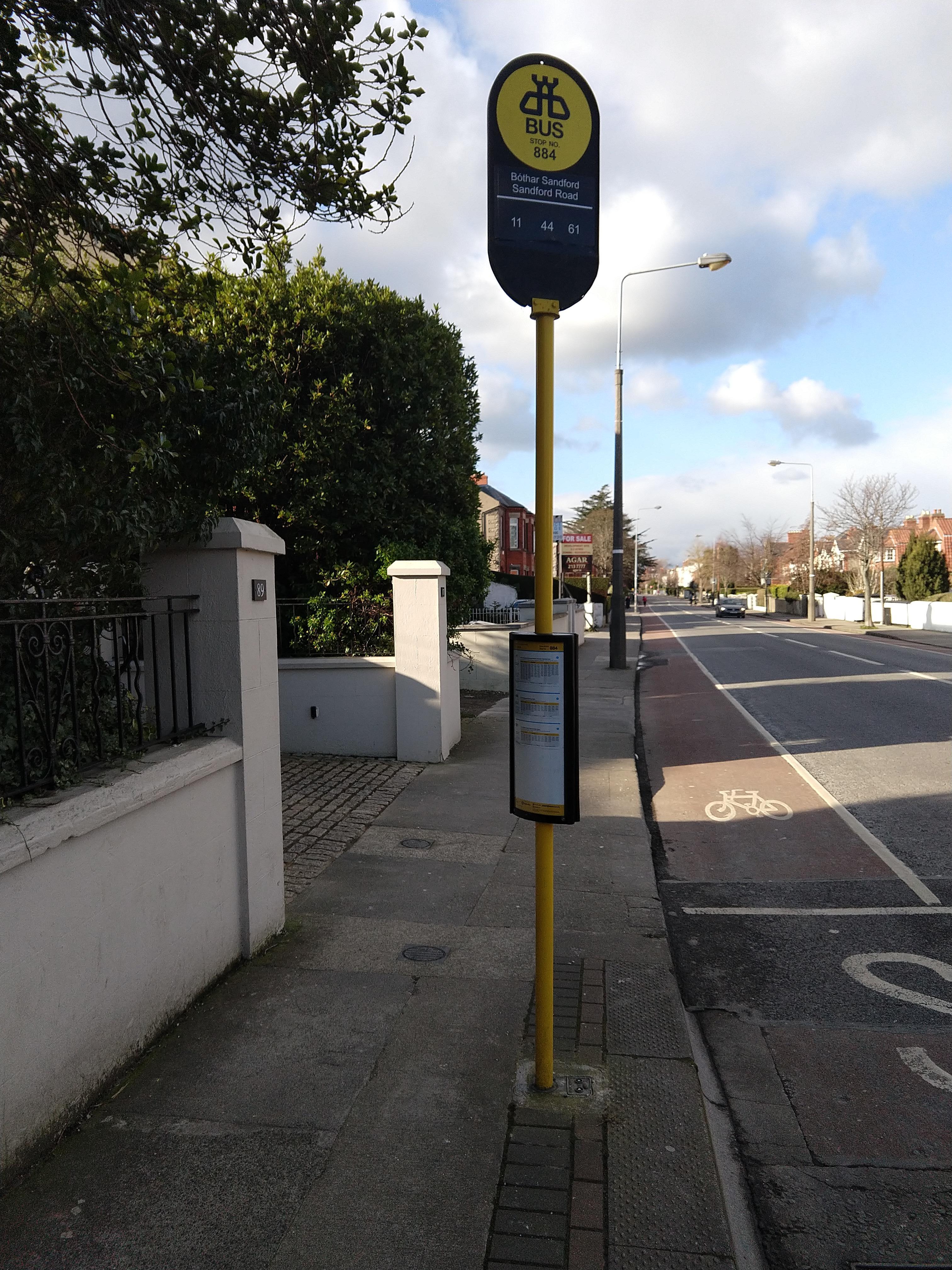 Taken by nestor v.
See Norwood Park stop, Dublin, on the map
Public transit to Norwood Park stop (ID: 884) in Dublin
Looking for directions to Norwood Park in Dublin, Ireland?
Download the Moovit App to find the current schedule and step-by-step directions for Bus, Train or Light Rail routes that pass through Norwood Park.
Looking for the nearest stops closest to Norwood Park ? Check out this list of closest stops to your destination: Sandford Road; Victoria Avenue; Donnybrook Village; Donnybrook; Beechwood.
Bus: 11, 39A, 44, 7B, 44D, E1, X1, E2, X2, 118, 32X.Train: DART, RAIL.
We make riding on public transit to Norwood Park easy, which is why over 1.5 million users, including users in Dublin trust Moovit as the best app for public transit.
Use the app to navigate to popular places including to the airport, hospital, stadium, grocery store, mall, coffee shop, school, college, and university.
Norwood Park stop’s code is 884
The first line to this stop is 44D, at 6:44 AM, and the last line is 11 at 11:46 PM.
93 Sandford Road, Dublin, Ireland
This stop serves Bus Átha Cliath – Dublin Bus’s lines
- Sandford Road,
- Victoria Avenue,
- Donnybrook Village,
- Donnybrook
Bus stops near Norwood Park stop
- Beechwood
Light Rail station near Norwood Park station
- East Wall, East Wall Road,
- Greengates,
- Richmond Street South,
- Ballintemple,
- Rathmullan Road,
- Corkagh Demesne,
- Kilbarrack Road,
- Mount Merrion Avenue,
- Dublin City South, South Great George's Street,
- Clonskeagh,
- North Bull Island,
- Belgard Retail Park,
- Ballyboughal,
- Carrigtwohill,
- Caherline,
- Cork Kent Station,
- Castle Park,
- Myrtleville,
- Bachelors Walk,
- Woodbrook Lawn
Popular public transit stations in Dublin
Get around Dublin by public transit!
Traveling around Dublin has never been so easy. See step by step directions as you travel to any attraction, street or major public transit station. View bus and train schedules, arrival times, service alerts and detailed routes on a map, so you know exactly how to get to anywhere in Dublin.
When traveling to any destination around Dublin use Moovit's Live Directions with Get Off Notifications to know exactly where and how far to walk, how long to wait for your line, and how many stops are left. Moovit will alert you when it's time to get off — no need to constantly re-check whether yours is the next stop.
Wondering how to use public transit in Dublin or how to pay for public transit in Dublin? Moovit public transit app can help you navigate your way with public transit easily, and at minimum cost. It includes public transit fees, ticket prices, and costs. Looking for a map of Dublin public transit lines? Moovit public transit app shows all public transit maps in Dublin with all Bus, Train and Light Rail routes and stops on an interactive map.
Ireland has 3 transit type(s), including: Bus, Train and Light Rail, operated by several transit agencies, including Luas, Bus Átha Cliath – Dublin Bus, Bus Éireann, Go-Ahead Ireland, Nitelink, Dublin Bus, Citylink, City Direct, Kenneally's Bus Service, Aircoach, TFI Local Link Mayo, Irish Rail, Express Bus, JJ/Bernard Kavanagh, Dublin Coach and Kearns Transport