Directions to Note (Quelfes) with public transportation
The following transit lines have routes that pass near Note
 Bus: 62, 66, LINHA AMARELA, LINHA VERDE, LINHA AZUL.
- Train: R.
- Ferry: OLHÃO - ARMONA, OLHÃO - CULATRA - FAROL.
How to get to Note by bus?
Click on the bus route to see step by step directions with maps, line arrival times and updated time schedules.
From Multibanco, Faro (Sé e São Pedro)
53 minFrom Eduardo Ramon, Faro (Sé e São Pedro)
33 minFrom Multibanco, Moncarapacho e Fuseta
27 minFrom Parque de Estacionamento, Faro (Sé e São Pedro)
34 minFrom ALDI, Faro
55 minFrom Loja Fresca, Faro (Sé e São Pedro)
54 minFrom Gulosa Tentação, Faro
53 minFrom Largo de São Francisco, Faro (Sé e São Pedro)
30 minFrom Mycenter - Sports & Wellness, Faro
55 minFrom Pastas Italianas, Faro (Sé e São Pedro)
28 min
How to get to Note by train?
Click on the train route to see step by step directions with maps, line arrival times and updated time schedules.
Bus stops near Note in Quelfes
Train station near Note in Quelfes
- Olhao, 15 min walk,VIEW
Ferry station near Note in Quelfes
- Olhão, 25 min walk,VIEW
Bus lines to Note in Quelfes
- LINHA AMARELA, Circular por Pechão,VIEW
- LINHA VERDE, Circular,VIEW
- LINHA AZUL, Linha Azul,VIEW
- LINHA AZUL A, Linha Azul A,VIEW
- 62, Olhão – Moncarapacho (por Fuzeta e Poço da Areia),VIEW
- 63, Faro – Olhão,VIEW
- 66, Albufeira - Vila Real de Sto. António,VIEW
- 67, Faro – Vila Real de Sto. António,VIEW
- 68, Olhão – Loulé,VIEW
- 69, Olhão – Univ. Algarve (Gambelas),VIEW
- 101, Olhão – Moncarapacho,VIEW
- 102, Pechão (R. Francisco Guerreiro),VIEW
What are the closest stations to Note?
The closest stations to Note are:
- Rep. Finanças is 32 meters away, 1 min walk.
- Olhão (Rep. Finanças) is 55 meters away, 1 min walk.
- Olhão (Quatro Estradas) is 560 meters away, 8 min walk.
- Olhao is 1083 meters away, 15 min walk.
- Olhão is 1917 meters away, 25 min walk.
Which bus lines stop near Note?
These bus lines stop near Note: 62, 66.
Which train line stops near Note?
R (Vila Real De Santo Antonio)
What’s the nearest train station to Note in Quelfes?
The nearest train station to Note in Quelfes is Olhao. It’s a 15 min walk away.
What’s the nearest bus station to Note in Quelfes?
The nearest bus stations to Note in Quelfes are Rep. Finanças and Olhão (Rep. Finanças). The closest one is a 1 min walk away.
What’s the nearest ferry station to Note in Quelfes?
The nearest ferry station to Note in Quelfes is Olhão. It’s a 25 min walk away.
What time is the first train to Note in Quelfes?
The R is the first train that goes to Note in Quelfes. It stops nearby at 6:44 AM.
What time is the last train to Note in Quelfes?
The R is the last train that goes to Note in Quelfes. It stops nearby at 10:27 PM.
What time is the first bus to Note in Quelfes?
The LINHA VERDE is the first bus that goes to Note in Quelfes. It stops nearby at 7:03 AM.
What time is the last bus to Note in Quelfes?
The LINHA AZUL is the last bus that goes to Note in Quelfes. It stops nearby at 8:17 PM.
What time is the first ferry to Note in Quelfes?
The OLHÃO - CULATRA - FAROL is the first ferry that goes to Note in Quelfes. It stops nearby at 7:00 AM.
What time is the last ferry to Note in Quelfes?
The OLHÃO - CULATRA - FAROL is the last ferry that goes to Note in Quelfes. It stops nearby at 7:20 PM.
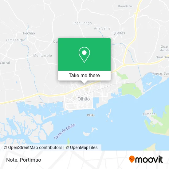
See Note, Quelfes, on the map
Public Transit to Note in Quelfes
Wondering how to get to Note in Quelfes? Moovit helps you find the best way to get to Note with step-by-step directions from the nearest public transit station.
Moovit provides free maps and live directions to help you navigate through your city. View schedules, routes, timetables, and find out how long does it take to get to Note in real time.
Looking for the nearest stop or station to Note? Check out this list of stops closest to your destination: Rep. Finanças; Olhão (Rep. Finanças); Olhão (Quatro Estradas); Olhao; Olhão.
Bus: 62, 66, LINHA AMARELA, LINHA VERDE, LINHA AZUL, LINHA AZUL A, 63, 102.Train: R.Ferry: OLHÃO - ARMONA, OLHÃO - CULATRA - FAROL.
Want to see if there’s another route that gets you there at an earlier time? Moovit helps you find alternative routes or times. Get directions from and directions to Note easily from the Moovit App or Website.
We make riding to Note easy, which is why over 1.5 million users, including users in Quelfes, trust Moovit as the best app for public transit. You don’t need to download an individual bus app or train app, Moovit is your all-in-one transit app that helps you find the best bus time or train time available.
For information on prices of bus and train, costs and ride fares to Note, please check the Moovit app.
Use the app to navigate to popular places including to the airport, hospital, stadium, grocery store, mall, coffee shop, school, college, and university.
Note Address: Olhão, 8700 Olhão street in Quelfes
- D. Franguito,
- Alain Afflelou Óptico - Olhao,
- Loja nos,
- Ginásio Bodyfit Olhao,
- W52,
- Code,
- Vivafit,
- Box,
- Serra Algarvia Em Olhão,
- AL-Sultão,
- Algarve Outlet,
- Douglas,
- Ria Shopping,
- OLH-00001,
- Dulci Caffe,
- Indoor Karting,
- Jumbo - Pão de Açúcar,
- Restaurante Burger Ranch Em Lisboa,
- Power Dot,
- Urbanização Vila Formosa
Places Near Note (Quelfes)
- Algarve Shopping, Guia,
- Portimão Retail Park, Portimão,
- Paragem - Rede Expresso, Portimão,
- Praia da Rocha, Portimão,
- P123 Lagos, São Gonçalo de Lagos,
- centro hospitalar do algarve - portimão, Portimão,
- Juliana Tantric Massage, Portimão,
- Fórum Algarve, Faro, Faro (Sé e São Pedro),
- Aquashow Park Hotel, Quarteira,
- Autodromo Internacional Algarve, Mexilhoeira Grande,
- Aqua Portimão, Portimão,
- Aquashow Park, Quarteira,
- Aqua Shopping Centre, Portimão,
- Zona Ribeirinha de Portimão, Portimão,
- Tchu Tchu Alvor, Alvor,
- Gare Rodoviária De Portimão, Portimão,
- Praia da Restinga, Mexilhoeira Grande,
- Univ. do Algarve-Campus de Gambelas, Faro,
- Pedra Mourinha, Portimão,
- Centro Comercial Continente Portimão, Portimão
How to get to popular places in Portimao with public transit
Get around Quelfes by public transit!
Traveling around Quelfes has never been so easy. See step by step directions as you travel to any attraction, street or major public transit station. View bus and train schedules, arrival times, service alerts and detailed routes on a map, so you know exactly how to get to anywhere in Quelfes.
When traveling to any destination around Quelfes use Moovit's Live Directions with Get Off Notifications to know exactly where and how far to walk, how long to wait for your line, and how many stops are left. Moovit will alert you when it's time to get off — no need to constantly re-check whether yours is the next stop.
Wondering how to use public transit in Quelfes or how to pay for public transit in Quelfes? Moovit public transit app can help you navigate your way with public transit easily, and at minimum cost. It includes public transit fees, ticket prices, and costs. Looking for a map of Quelfes public transit lines? Moovit public transit app shows all public transit maps in Quelfes with all Bus, Train and Ferry routes and stops on an interactive map.
Portimao has 3 transit type(s), including: Bus, Train and Ferry, operated by several transit agencies, including Barcos da Carreira de Olhão, Apanha-me! - Transportes Urbanos, CP - Comboios de Portugal, A Onda - Mobilidade Urbana, Vai e Vem - Circuito Urbano, Próximo - Transportes Urbanos de Faro, Vamus Algarve, CUBO, GIRO - Transportes Urbanos and Sobe e Desce - Transportes Urbanos de Tavira