Directions to Oliver Economic Development (Baltimore) with public transportation
The following transit lines have routes that pass near Oliver Economic Development
 Bus: 21, 54, CITYLINK GOLD, CITYLINK LIME.
- Train: MARC, ACELA, CARDINAL, CAROLINIAN, CRESCENT.
- Metro: METRO.
How to get to Oliver Economic Development by bus?
Click on the bus route to see step by step directions with maps, line arrival times and updated time schedules.
From Eastern Ave (eastern avenue and dundalk av), Baltimore
41 minFrom Dundalk, Maryland, Baltimore County
52 minFrom Towson, MD, Baltimore County
46 minFrom Reisterstown Road Plaza, Baltimore
66 minFrom Pimlico Race Course, Baltimore
69 minFrom Medstar Franklin Square Medical Center, Baltimore County
51 minFrom Mva, Baltimore
57 minFrom Towson Town Center, Baltimore County
48 minFrom I-695 Exit 29 (Loch Raven Blvd (MD 542)/Cromwell Bridge Rd), Baltimore County
52 minFrom Saint Agnes Hospital, Baltimore
48 min
How to get to Oliver Economic Development by metro?
Click on the metro route to see step by step directions with maps, line arrival times and updated time schedules.
Bus stops near Oliver Economic Development in Baltimore
Metro station near Oliver Economic Development in Baltimore
- Johns Hopkins Metro, 22 min walk,VIEW
Light Rail stations near Oliver Economic Development in Baltimore
- Penn Station, 38 min walk,VIEW
Train stations near Oliver Economic Development in Baltimore
Bus lines to Oliver Economic Development in Baltimore
What are the closest stations to Oliver Economic Development?
The closest stations to Oliver Economic Development are:
- Harford Ave & Federal St FS Nb is 231 yards away, 3 min walk.
- North Ave & Harford Rd FS Eb is 509 yards away, 7 min walk.
- Preston St & Caroline St Wb FS is 652 yards away, 8 min walk.
- Johns Hopkins Metro is 1797 yards away, 22 min walk.
- Penn Station is 3161 yards away, 38 min walk.
- Penn Station Marc Sb is 3274 yards away, 39 min walk.
- Baltimore Penn Station is 3280 yards away, 39 min walk.
Which bus lines stop near Oliver Economic Development?
These bus lines stop near Oliver Economic Development: 21, 54, CITYLINK GOLD.
Which metro line stops near Oliver Economic Development?
METRO (Towards John Hopkins)
What’s the nearest metro station to Oliver Economic Development in Baltimore?
The nearest metro station to Oliver Economic Development in Baltimore is Johns Hopkins Metro. It’s a 22 min walk away.
What’s the nearest bus station to Oliver Economic Development in Baltimore?
The nearest bus station to Oliver Economic Development in Baltimore is Harford Ave & Federal St FS Nb. It’s a 3 min walk away.
What time is the first light rail to Oliver Economic Development in Baltimore?
The LIGHT RAILLINK is the first light rail that goes to Oliver Economic Development in Baltimore. It stops nearby at 3:56 AM.
What time is the last light rail to Oliver Economic Development in Baltimore?
The LIGHT RAILLINK is the last light rail that goes to Oliver Economic Development in Baltimore. It stops nearby at 11:44 PM.
What time is the first metro to Oliver Economic Development in Baltimore?
The METRO is the first metro that goes to Oliver Economic Development in Baltimore. It stops nearby at 4:21 AM.
What time is the last metro to Oliver Economic Development in Baltimore?
The METRO is the last metro that goes to Oliver Economic Development in Baltimore. It stops nearby at 12:29 AM.
What time is the first train to Oliver Economic Development in Baltimore?
The MARC is the first train that goes to Oliver Economic Development in Baltimore. It stops nearby at 4:30 AM.
What time is the last train to Oliver Economic Development in Baltimore?
The SILVER METEOR is the last train that goes to Oliver Economic Development in Baltimore. It stops nearby at 7:57 AM.
What time is the first bus to Oliver Economic Development in Baltimore?
The CITYLINK GOLD is the first bus that goes to Oliver Economic Development in Baltimore. It stops nearby at 3:31 AM.
What time is the last bus to Oliver Economic Development in Baltimore?
The 54 is the last bus that goes to Oliver Economic Development in Baltimore. It stops nearby at 3:07 AM.
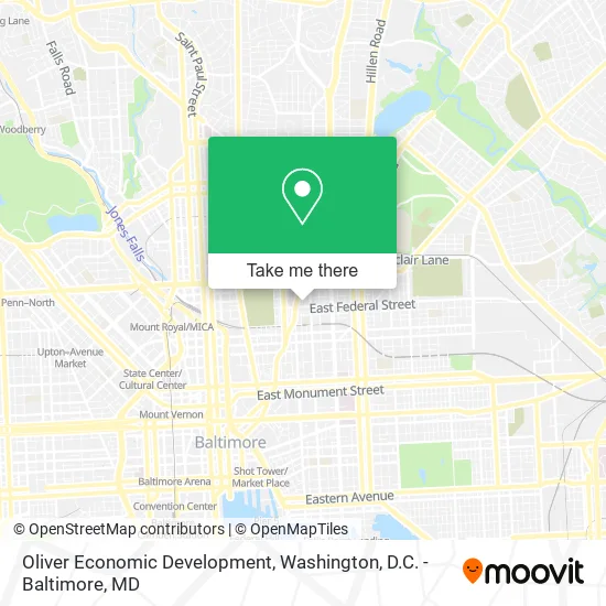
See Oliver Economic Development, Baltimore, on the map
Public Transit to Oliver Economic Development in Baltimore
Wondering how to get to Oliver Economic Development in Baltimore? Moovit helps you find the best way to get to Oliver Economic Development with step-by-step directions from the nearest public transit station.
Moovit provides free maps and live directions to help you navigate through your city. View schedules, routes, timetables, and find out how long does it take to get to Oliver Economic Development in real time.
Looking for the nearest stop or station to Oliver Economic Development? Check out this list of stops closest to your destination: Harford Ave & Federal St FS Nb; North Ave & Harford Rd FS Eb; Preston St & Caroline St Wb FS; Johns Hopkins Metro; Penn Station; Penn Station Marc Sb; Baltimore Penn Station.
Bus: 21, 54, CITYLINK GOLD, CITYLINK LIME.Train: MARC, ACELA, CARDINAL, CAROLINIAN, CRESCENT, NORTHEAST REGIONAL.Metro: METRO.
Want to see if there’s another route that gets you there at an earlier time? Moovit helps you find alternative routes or times. Get directions from and directions to Oliver Economic Development easily from the Moovit App or Website.
We make riding to Oliver Economic Development easy, which is why over 1.5 million users, including users in Baltimore, trust Moovit as the best app for public transit. You don’t need to download an individual bus app or train app, Moovit is your all-in-one transit app that helps you find the best bus time or train time available.
For information on prices of bus and metro, costs and ride fares to Oliver Economic Development, please check the Moovit app.
Use the app to navigate to popular places including to the airport, hospital, stadium, grocery store, mall, coffee shop, school, college, and university.
Oliver Economic Development Address: 1400 E Federal St Baltimore, MD 21213 street in Baltimore
- Hope Center,
- Amazon Locker-Biro,
- Locksmith of Baltimore,
- Ims,
- Min Min,
- Food Servsafe 식품위생 면허 교육.시험,
- Mc Call's Grocery,
- The Bethel Farm Lab,
- Caroline & Hoffman Park / Calvin B. Scruggs, Sr. Park,
- Caroline & Hoffman Park,
- Global Pest Control,
- Operation Oliver,
- Bethel Street Garden,
- Harford Rd (harford road and E North Ave),
- Veggeez,
- Wholistic Wellness Suite,
- Maryland Assisted Living Home,
- MTA Bus Stop - North Ave & Harford Rd,
- 1ne Touch Mobile Automotive,
- The Gale House - A Gifted Assisted Living Environment
Places Near Oliver Economic Development (Baltimore)
- Georgetown, Washington,
- Basilica of the National Shrine, Washington,
- Warner Theatre, Washington,
- Westfield Montgomery Mall, Montgomery County,
- Camden Yards, Baltimore,
- Marriott Marquis Washington, DC, Washington,
- Museum Of The Bible, Washington,
- Rock Creek Tennis Center, Washington,
- National Zoo, Washington,
- Washington National Cathedral, Washington,
- The Anthem, Washington,
- Washington DC VA Medical Center, Washington,
- M&T Bank Stadium, Baltimore,
- Sibley Memorial Hospital, Washington,
- PG Mall, Prince George's County,
- Capital One Arena, Washington,
- National Theatre, Washington,
- National Museum of African American History and Culture, Washington,
- Pennsylvania Ave NW (3rd st and pennsylvania), Washington,
- Amazon Hq2, Arlington County
How to get to popular places in Washington, D.C. - Baltimore, MD with public transit
Get around Baltimore by public transit!
Traveling around Baltimore has never been so easy. See step by step directions as you travel to any attraction, street or major public transit station. View bus and train schedules, arrival times, service alerts and detailed routes on a map, so you know exactly how to get to anywhere in Baltimore.
When traveling to any destination around Baltimore use Moovit's Live Directions with Get Off Notifications to know exactly where and how far to walk, how long to wait for your line, and how many stops are left. Moovit will alert you when it's time to get off — no need to constantly re-check whether yours is the next stop.
Wondering how to use public transit in Baltimore or how to pay for public transit in Baltimore? Moovit public transit app can help you navigate your way with public transit easily, and at minimum cost. It includes public transit fees, ticket prices, and costs. Looking for a map of Baltimore public transit lines? Moovit public transit app shows all public transit maps in Baltimore with all Bus, Train, Metro, Light Rail and Ferry routes and stops on an interactive map.
Washington, D.C. - Baltimore, MD has 5 transit type(s), including: Bus, Train, Metro, Light Rail and Ferry, operated by several transit agencies, including WMATA, Montgomery County Ride On, Fairfax Connector, TheBus, PRTC, DASH - Alexandria, Arlington Transit (ART), RTA of Central Maryland, MDOT MTA, MDOT MTA Light RailLink, MDOT MTA Commuter Bus, MDOT MTA Local Bus, FXBGO!, Virginia Railway Express (VRE) and MARC