Orthodox St & Almond St stop - Friday schedule
| Line | Direction | Time |
|---|---|---|
| 25 | Front-Spring Garden | 4:55 AM |
| 25 | Columbus Commons | 5:11 AM |
| 25 | Front-Spring Garden | 5:27 AM |
| 25 | Columbus Commons | 5:44 AM |
| 25 | Front-Spring Garden | 5:58 AM |
| 25 | Columbus Commons | 6:13 AM |
| 25 | Front-Spring Garden | 6:28 AM |
| 41 | Richmond-Orthodox | 6:32 AM |
| 25 | Columbus Commons | 6:43 AM |
| 25 | Front-Spring Garden | 6:55 AM |
| 41 | Richmond-Orthodox | 7:01 AM |
| 25 | Columbus Commons | 7:07 AM |
| 25 | Front-Spring Garden | 7:22 AM |
| 41 | Richmond-Orthodox | 7:35 AM |
| 25 | Columbus Commons | 7:37 AM |
| 25 | Front-Spring Garden | 7:53 AM |
| 41 | Richmond-Orthodox | 8:06 AM |
| 25 | Columbus Commons | 8:08 AM |
| 41 | Richmond-Orthodox | 8:30 AM |
| 25 | Columbus Commons | 8:30 AM |
| 41 | Richmond-Orthodox | 8:55 AM |
| 25 | Columbus Commons | 9:00 AM |
| 41 | Richmond-Orthodox | 9:25 AM |
| 25 | Columbus Commons | 9:30 AM |
| 41 | Richmond-Orthodox | 9:55 AM |
Directions to Orthodox St & Almond St stop (Philadelphia) with public transit
The following transit lines have routes that pass near Orthodox St & Almond St
 Bus: 25, 41, 73.
- Train: TRE.
- Metro: L1.
- Cable Car: 75, 89.
How to get to Orthodox St & Almond St stop by bus?
Click on the bus route to see step by step directions with maps, line arrival times and updated time schedules.
How to get to Orthodox St & Almond St stop by train?
Click on the train route to see step by step directions with maps, line arrival times and updated time schedules.
How to get to Orthodox St & Almond St stop by metro?
Click on the metro route to see step by step directions with maps, line arrival times and updated time schedules.
Bus stops near Orthodox St & Almond St stop in Philadelphia
- Orthodox St & Belgrade St , 2 min walk,
- Thompson St & Orthodox St , 2 min walk,
Metro stations near Orthodox St & Almond St station in Philadelphia
- Church Station, 5 min walk,
Train stations near Orthodox St & Almond St station in Philadelphia
- Bridesburg, 10 min walk,
Cable Car stations near Orthodox St & Almond St station in Philadelphia
- Penn St & Overington St , 11 min walk,
Bus lines to Orthodox St & Almond St stop in Philadelphia
- 25, Frankford Transit Center,
- 41, Chelten-Wissahickon,
- 73, Richmond-Westmoreland,
What are the closest stations to Orthodox St & Almond St?
The closest stations to Orthodox St & Almond St are:
- Orthodox St & Belgrade St stop is 95 yards away, 2 min walk.
- Thompson St & Orthodox St stop is 121 yards away, 2 min walk.
- Church Station is 413 yards away, 5 min walk.
- Bridesburg station is 799 yards away, 10 min walk.
- Penn St & Overington St station is 879 yards away, 11 min walk.
Which bus lines stop near Orthodox St & Almond St?
These bus lines stop near Orthodox St & Almond St: 25, 41.
Which train line stops near Orthodox St & Almond St?
TRE (#Tre9719 - Trenton)
Which metro line stops near Orthodox St & Almond St?
L1 (Frankford Transit Center)
What’s the nearest metro station to Orthodox St & Almond St in Philadelphia?
The nearest metro station to Orthodox St & Almond St in Philadelphia is Church Station. It’s a 5 min walk away.
What’s the nearest train station to Orthodox St & Almond St in Philadelphia?
The nearest train station to Orthodox St & Almond St in Philadelphia is Bridesburg. It’s a 10 min walk away.
What’s the nearest bus station to Orthodox St & Almond St in Philadelphia?
The nearest bus stations to Orthodox St & Almond St in Philadelphia are Orthodox St & Belgrade St and Thompson St & Orthodox St. The closest one is a 2 min walk away.
What’s the nearest cable car station to Orthodox St & Almond St in Philadelphia?
The nearest cable car station to Orthodox St & Almond St in Philadelphia is Penn St & Overington St. It’s a 11 min walk away.
What time is the first metro to Orthodox St & Almond St in Philadelphia?
The L1 is the first metro that goes to Orthodox St & Almond St in Philadelphia. It stops nearby at 4:59 AM.
What time is the last metro to Orthodox St & Almond St in Philadelphia?
The L1 is the last metro that goes to Orthodox St & Almond St in Philadelphia. It stops nearby at 12:39 AM.
What time is the first train to Orthodox St & Almond St in Philadelphia?
The TRE is the first train that goes to Orthodox St & Almond St in Philadelphia. It stops nearby at 4:23 AM.
What time is the last train to Orthodox St & Almond St in Philadelphia?
The TRE is the last train that goes to Orthodox St & Almond St in Philadelphia. It stops nearby at 12:31 AM.
What time is the first bus to Orthodox St & Almond St in Philadelphia?
The 73 is the first bus that goes to Orthodox St & Almond St in Philadelphia. It stops nearby at 3:05 AM.
What time is the last bus to Orthodox St & Almond St in Philadelphia?
The 73 is the last bus that goes to Orthodox St & Almond St in Philadelphia. It stops nearby at 2:49 AM.
What time is the first cable car to Orthodox St & Almond St in Philadelphia?
The 75 is the first cable car that goes to Orthodox St & Almond St in Philadelphia. It stops nearby at 5:36 AM.
What time is the last cable car to Orthodox St & Almond St in Philadelphia?
The 75 is the last cable car that goes to Orthodox St & Almond St in Philadelphia. It stops nearby at 2:02 AM.
Orthodox St & Almond St station
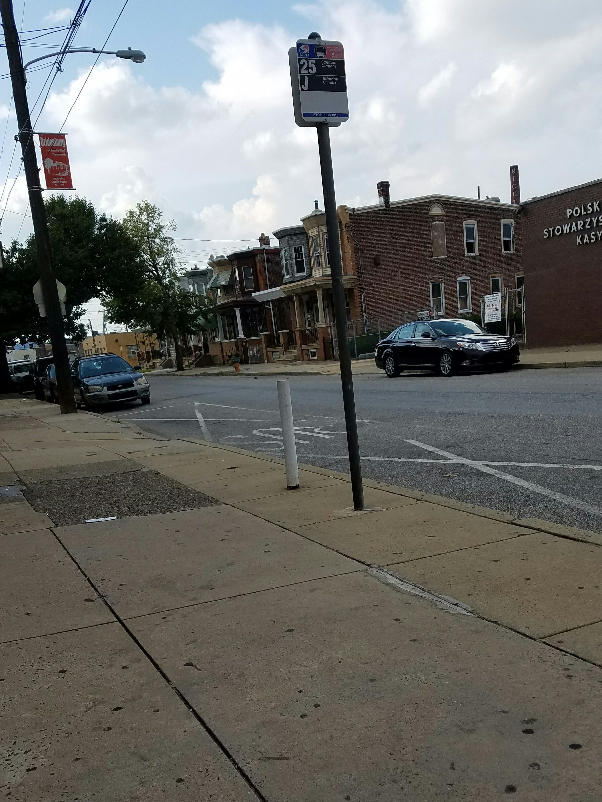 Taken by Anonymous
See Orthodox St & Almond St stop, Philadelphia, on the map
Public transit to Orthodox St & Almond St stop (ID: 24016) in Philadelphia
Looking for directions to Orthodox St & Almond St in Philadelphia, United States?
Download the Moovit App to find the current schedule and step-by-step directions for Bus, Metro or Train routes that pass through Orthodox St & Almond St.
Looking for the nearest stops closest to Orthodox St & Almond St ? Check out this list of closest stops to your destination: Orthodox St & Belgrade St ; Thompson St & Orthodox St ; Church Station; Bridesburg; Penn St & Overington St .
Bus: 25, 41, 73.Train: TRE.Metro: L1.Cable Car: 75, 89.
We make riding on public transit to Orthodox St & Almond St easy, which is why over 1.7 billion users, including users in Philadelphia trust Moovit as the best app for public transit.
Use the app to navigate to popular places including to the airport, hospital, stadium, grocery store, mall, coffee shop, school, college, and university.
Orthodox St & Almond St stop’s code is 24016
The first line to this stop is 25, at 4:55 AM, and the last line is 41 at 2:24 AM.
2578 Orthodox St, Philadelphia, PA, USA
This stop serves SEPTA’s lines
- Orthodox St & Belgrade St ,
- Thompson St & Orthodox St
Bus stops near Orthodox St & Almond St stop
- Church Station
Metro station near Orthodox St & Almond St station
- Bridesburg
Train station near Orthodox St & Almond St station
- Penn St & Overington St
Cable Car station near Orthodox St & Almond St station
- Haddonfield Patco,
- Ridley Park,
- Spring Garden St & 8th St,
- Frankford Transit Center,
- 3rd St & Chestnut St,
- Berks Station,
- Einstein Medical Ctr - South Entrance,
- 61st St & Passyunk Av - Fs,
- County Line Rd & Easton Rd,
- 19th St,
- 17th St & Huntingdon St,
- 22nd St & Lehigh Av,
- Tasker St & 33rd St,
- Whitman Plaza - 1,
- Glenside Av & Easton Rd ,
- 2nd St Station,
- Lansdale,
- 13th St & Market St - Mbfs,
- 12th St & Lombard St,
- 58th St & Baltimore Av
Popular public transit stations in Philadelphia
Get around Philadelphia by public transit!
Traveling around Philadelphia has never been so easy. See step by step directions as you travel to any attraction, street or major public transit station. View bus and train schedules, arrival times, service alerts and detailed routes on a map, so you know exactly how to get to anywhere in Philadelphia.
When traveling to any destination around Philadelphia use Moovit's Live Directions with Get Off Notifications to know exactly where and how far to walk, how long to wait for your line, and how many stops are left. Moovit will alert you when it's time to get off — no need to constantly re-check whether yours is the next stop.
Wondering how to use public transit in Philadelphia or how to pay for public transit in Philadelphia? Moovit public transit app can help you navigate your way with public transit easily, and at minimum cost. It includes public transit fees, ticket prices, and costs. Looking for a map of Philadelphia public transit lines? Moovit public transit app shows all public transit maps in Philadelphia with all Bus, Train, Metro, Light Rail and Cable Car routes and stops on an interactive map.
Philadelphia has 5 transit type(s), including: Bus, Train, Metro, Light Rail and Cable Car, operated by several transit agencies, including SEPTA Subway, SEPTA Rail, SEPTA, SEPTA Trolley, NJ Transit Rail, NJ Transit, Port Authority Transit Corporation, Navy Yard, Penn Transit, Drexel University, Pottstown Area Rapid Transit (PART), Fullington Tours, Chescobus, Amtrak and Greyhound-us