Directions to Otvovice (Kladno) with public transportation
The following transit lines have routes that pass near Otvovice
How to get to Otvovice by bus?
Click on the bus route to see step by step directions with maps, line arrival times and updated time schedules.
How to get to Otvovice by train?
Click on the train route to see step by step directions with maps, line arrival times and updated time schedules.
Bus stations near Otvovice in Kladno
- Zákolanytrněný Újezd (A),30 min walk,
Bus lines to Otvovice in Kladno
- 456,Želenice,
What are the closest stations to Otvovice?
The closest stations to Otvovice are:
- Zákolanytrněný Újezd (A) is 2268 meters away, 30 min walk.
Which bus line stops near Otvovice?
316
Which train line stops near Otvovice?
S45
See Otvovice, Kladno, on the map
Public Transit to Otvovice in Kladno
Wondering how to get to Otvovice in Kladno, Czech Republic? Moovit helps you find the best way to get to Otvovice with step-by-step directions from the nearest public transit station.
Moovit provides free maps and live directions to help you navigate through your city. View schedules, routes, timetables, and find out how long does it take to get to Otvovice in real time.
Looking for the nearest stop or station to Otvovice? Check out this list of stops closest to your destination: Zákolanytrněný Újezd (A).
Bus:316456Train:S45
Want to see if there’s another route that gets you there at an earlier time? Moovit helps you find alternative routes or times. Get directions from and directions to Otvovice easily from the Moovit App or Website.
We make riding to Otvovice easy, which is why over 1.5 million users, including users in Kladno, trust Moovit as the best app for public transit. You don’t need to download an individual bus app or train app, Moovit is your all-in-one transit app that helps you find the best bus time or train time available.
For information on prices of bus, train and light rail, costs and ride fares to Otvovice, please check the Moovit app.
Use the app to navigate to popular places including to the airport, hospital, stadium, grocery store, mall, coffee shop, school, college, and university.
Location: Kladno, Prague
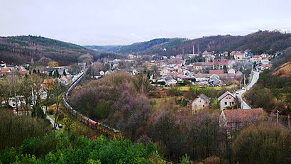
Otvovice is a village and municipality in Kladno District in the Central Bohemian Region of the Czech Republic.Wiki
Attractions near Otvovice
Rybníček U Dvou Potápek,Otvovické Koupaliště,Koupaliště Otvovice,Otvovická skála,Sprašová rokle Zeměchy,Zákolany;Otvovice,Hostinec Zeměchy,Trněný Újezd,Mikovice,Kralupy Nad Vltavou Předměstí,Kostel Narození Panny Marie,Zákolany Zastávka,V Růžovém údolí,Piánka Zákolany,Stadion Antonína Vašátka,Zákolany,AUTO KRALUPY a.s.,Zákolany,Holubický rybníček,Fotbalové hřiště TJ Sokol HolubiceHow to get to popular attractions in Kladno with public transit
Pavilon A4 - Fakultní Thomayerova nemocnice s poliklinikou, Praha 4,Nusle, Praha 4,Divadlo Na Jezerce, Praha 4,Poliklinika Malešice, Praha 10,Blokanda, Praha 22,Zahrádkářská kolonie Barrandov, Praha 5,hala Radlice, Praha 5,Sicherova, Praha-Satalice,Valdštejnský Palác, Praha 1,Kodaňská-28.Pluku, Praha 10,Dobrejovice na navsi Bus, Praha - Východ,Řepy, Praha 17,Stará Boleslav, Mladá Boleslav,Clarion Hotel Prague, Praha 1,Zahrádkářská kolonie Modřany / Cholupice, Praha 12,Odtahové parkoviště Holešovice, Praha 7,Benice, Praha-Benice,Novotného Lávka, Praha 1,Sídliště Petřiny, Praha 6,Česká Tržnice Na pankráci, Praha 4Get around Kladno by public transit!
Traveling around Kladno has never been so easy. See step by step directions as you travel to any attraction, street or major public transit station. View bus and train schedules, arrival times, service alerts and detailed routes on a map, so you know exactly how to get to anywhere in Kladno.
When traveling to any destination around Kladno use Moovit's Live Directions with Get Off Notifications to know exactly where and how far to walk, how long to wait for your line, and how many stops are left. Moovit will alert you when it's time to get off — no need to constantly re-check whether yours is the next stop.
Wondering how to use public transit in Kladno or how to pay for public transit in Kladno? Moovit public transit app can help you navigate your way with public transit easily, and at minimum cost. It includes public transit fees, ticket prices, and costs. Looking for a map of Kladno public transit lines? Moovit public transit app shows all public transit maps in Kladno with all bus, train or light rail routes and stops on an interactive map.
Kladno has 3 transit type(s), including: bus, train or light rail, operated by several transit agencies, including Dopravní podnik měst Liberce a Jablonce nad Nisou, a.s., Dopravní podnik měst Liberce a Jablonce nad Nisou, a.s., BusLine jižní Čechy s.r.o., Railway Capital a.s., Dopravní společnost Ústeckého kraje, příspěvková organizace, DPP, DPP, DPP, DPP, Dopravní podnik hl. m. Prahy, akciová společnost, České dráhy, a.s., KŽC Doprava,s.r.o., České dráhy a.s., ARRIVA vlaky s.r.o. and KAD BUS spol. s r.o.