How to get to Panthony by bus?
Click on the bus route to see step by step directions with maps, line arrival times and updated time schedules.
From Amazon-DBX8, Herbrechtingen
231 minFrom Media Markt, Gemeindeverwaltungsverband Eislingen-Ottenbach-Salach
246 minFrom Kloster Untermarchtal, Verwaltungsgemeinschaft Munderkingen
121 minFrom Möbel Rieger, Vereinbarte Verwaltungsgemeinschaft Der Stadt Göppingen
259 minFrom Heidenheim an der Brenz, Heidenheim An Der Brenz
144 minFrom Action, Gemeindeverwaltungsverband Eislingen-Ottenbach-Salach
251 minFrom HORNBACH, Vereinbarte Verwaltungsgemeinschaft Der Stadt Göppingen
248 minFrom Kaufland Geislingen, Vereinbarte Verwaltungsgemeinschaft Der Stadt Geislingen An Der Steige
181 min
How to get to Panthony by train?
Click on the train route to see step by step directions with maps, line arrival times and updated time schedules.
Bus stops near Panthony in Stuttgart
Light Rail stations near Panthony in Stuttgart
- Ulm Martin-Luther-Kirche Bstg B, 8 min walk,VIEW
Train stations near Panthony in Stuttgart
Bus lines to Panthony in Stuttgart
What are the closest stations to Panthony?
The closest stations to Panthony are:
- Ulm Leonberger Weg Bstg B is 168 meters away, 3 min walk.
- Ulm Maienweg Bstg A is 302 meters away, 4 min walk.
- Ulm Torstraße Bstg B is 536 meters away, 7 min walk.
- Ulm Martin-Luther-Kirche Bstg B is 602 meters away, 8 min walk.
- Ulm Söflingen is 758 meters away, 10 min walk.
- Ulm S-Bahnhalt Ulm-Söflingen is 1764 meters away, 23 min walk.
- Ulm-Söflingen is 2402 meters away, 31 min walk.
Which train lines stop near Panthony?
These train lines stop near Panthony: RS 3, RS3.
Which light rail line stops near Panthony?
1 (Ulm Söflingen)
Which bus lines stop near Panthony?
These bus lines stop near Panthony: 11, 21, 46, 585.
What’s the nearest light rail station to Panthony in Stuttgart?
The nearest light rail station to Panthony in Stuttgart is Ulm Martin-Luther-Kirche Bstg B. It’s a 8 min walk away.
What’s the nearest train station to Panthony in Stuttgart?
The nearest train station to Panthony in Stuttgart is Ulm S-Bahnhalt Ulm-Söflingen. It’s a 23 min walk away.
What’s the nearest bus station to Panthony in Stuttgart?
The nearest bus station to Panthony in Stuttgart is Ulm Leonberger Weg Bstg B. It’s a 3 min walk away.
What time is the first light rail to Panthony in Stuttgart?
The 2 is the first light rail that goes to Panthony in Stuttgart. It stops nearby at 4:40 AM.
What time is the last light rail to Panthony in Stuttgart?
The 1 is the last light rail that goes to Panthony in Stuttgart. It stops nearby at 1:11 AM.
What time is the first train to Panthony in Stuttgart?
The RS 3 is the first train that goes to Panthony in Stuttgart. It stops nearby at 4:53 AM.
What time is the last train to Panthony in Stuttgart?
The RE 55 is the last train that goes to Panthony in Stuttgart. It stops nearby at 11:29 PM.
What time is the first bus to Panthony in Stuttgart?
The 11 is the first bus that goes to Panthony in Stuttgart. It stops nearby at 4:45 AM.
What time is the last bus to Panthony in Stuttgart?
The MS9 is the last bus that goes to Panthony in Stuttgart. It stops nearby at 12:49 AM.
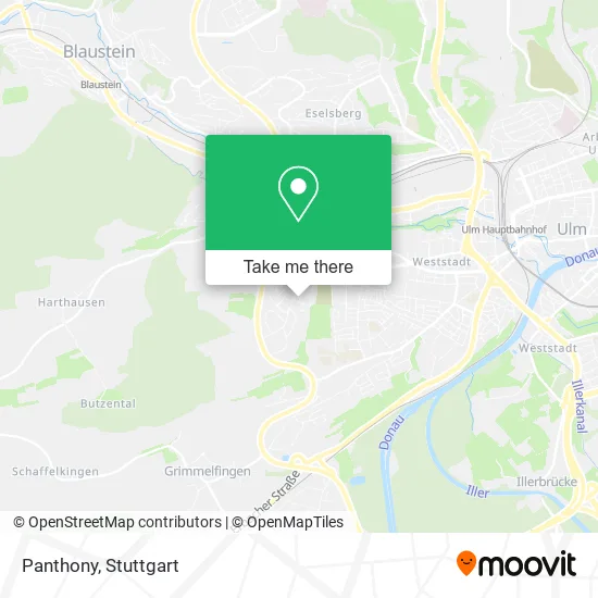
See Panthony, Stuttgart, on the map
Public Transit to Panthony in Stuttgart
Wondering how to get to Panthony in Stuttgart? Moovit helps you find the best way to get to Panthony with step-by-step directions from the nearest public transit station.
Moovit provides free maps and live directions to help you navigate through your city. View schedules, routes, timetables, and find out how long does it take to get to Panthony in real time.
Looking for the nearest stop or station to Panthony? Check out this list of stops closest to your destination: Ulm Leonberger Weg Bstg B; Ulm Maienweg Bstg A; Ulm Torstraße Bstg B; Ulm Martin-Luther-Kirche Bstg B; Ulm Söflingen; Ulm S-Bahnhalt Ulm-Söflingen; Ulm-Söflingen.
Train: RS 3, RS3, SAB, RE55, RE 55, RB 59.Light Rail: 1.Bus: 11, 21, 46, 585, 9, MS9, E, N1, 1, 8, MS9.
Want to see if there’s another route that gets you there at an earlier time? Moovit helps you find alternative routes or times. Get directions from and directions to Panthony easily from the Moovit App or Website.
We make riding to Panthony easy, which is why over 1.5 million users, including users in Stuttgart, trust Moovit as the best app for public transit. You don’t need to download an individual bus app or train app, Moovit is your all-in-one transit app that helps you find the best bus time or train time available.
For information on prices of bus, train and light rail, costs and ride fares to Panthony, please check the Moovit app.
Use the app to navigate to popular places including to the airport, hospital, stadium, grocery store, mall, coffee shop, school, college, and university.
Panthony Address: Eichhornweg 28 89081 Ulm street in Stuttgart
- Burgdörfer Software,
- Martha Hürlimann-Dewal,
- Pyramid Verwaltungs,
- Pyramid,
- Ev. Kita im Jörg Syrlinhaus,
- Sleep Doctor,
- Iptasys,
- Familie Ganzenmüller,
- Kinderkrippe Im Jörg-Syrlin-Haus,
- Familienzentrum,
- Heidelberg,
- Inasof,
- Jörg-Syrlin-Haus,
- Pilates4one,
- Janina Schmid,
- Lfmb-Vermögensverwaltungs,
- Kindertagesstätte,
- Kindergarten,
- Ev. Kindergarten,
- Kindergarten Im Jörg-Syrlin-Haus
Places Near Panthony (Stuttgart)
- Mercedes-Benz Museum (Mercedes Museum Stuttgart), Bad Cannstatt,
- Hanns-Martin-Schleyer-Halle (Stuttgart Hans-Martin-Schleyerhalle), Bad Cannstatt,
- Wilhelma (U-Bahn Wilhelma), Bad Cannstatt,
- Mettingen Eros-Center Puff Laufhaus, Esslingen Am Neckar,
- SI-Centrum, Möhringen,
- Waldfriedhof, Degerloch,
- Pariser Platz Stuttgart, Stuttgart-Mitte,
- Gleis 101/102 (tief), Stuttgart-Mitte,
- Gasometer Pforzheim, Pforzheim,
- Geilhaus Haus 33a, Reutlingen-Betzingen,
- Porsche Museum, Zuffenhausen,
- Im Wizemann (Halle), Bad Cannstatt,
- Klinikum Stuttgart - Katharinenhospital, Stuttgart-Mitte,
- Hauptbahnhof Stuttgart, Stuttgart-Mitte,
- Mercedes-Benz Museum, Bad Cannstatt,
- FlixBus Haltestelle, Stuttgart,
- Porsche-Arena, Bad Cannstatt,
- Schleyerhalle, Bad Cannstatt,
- Marmorsaal Im Weissenburgpark, Stuttgart-Süd,
- Hanns-Martin-Schleyer-Halle, Bad Cannstatt
How to get to popular places in Stuttgart with public transit
Get around Stuttgart by public transit!
Traveling around Stuttgart has never been so easy. See step by step directions as you travel to any attraction, street or major public transit station. View bus and train schedules, arrival times, service alerts and detailed routes on a map, so you know exactly how to get to anywhere in Stuttgart.
When traveling to any destination around Stuttgart use Moovit's Live Directions with Get Off Notifications to know exactly where and how far to walk, how long to wait for your line, and how many stops are left. Moovit will alert you when it's time to get off — no need to constantly re-check whether yours is the next stop.
Wondering how to use public transit in Stuttgart or how to pay for public transit in Stuttgart? Moovit public transit app can help you navigate your way with public transit easily, and at minimum cost. It includes public transit fees, ticket prices, and costs. Looking for a map of Stuttgart public transit lines? Moovit public transit app shows all public transit maps in Stuttgart with all Bus, Train, Subway, Light Rail, Ferry, S-Bahn and Funicular routes and stops on an interactive map.
Stuttgart has 7 transit type(s), including: Bus, Train, Subway, Light Rail, Ferry, S-Bahn and Funicular, operated by several transit agencies, including SSB - Stadtbahn, SSB, SSB - Seilbahn / Zacke, S-Bahn Stuttgart, Rhein-Neckar-Verkehr GmbH (rnv), Karlsruher Verkehrsverbund, DB AG, DB Regiobus BW, Arverio Baden-Württemberg GmbH, DB RegioNetz Verkehrs GmbH Westfrankenbahn, DB Regio AG Baden-Württemberg, Südwestdeutsche Verkehrs-AG, DB Regio AG Mitte Region Hessen, DB and Bodensee-Oberschwaben-Bahn