Paramount & 55th Way E stop - Friday schedule
| Line | Direction | Time |
|---|---|---|
| 111 | 111 Bdwy-Lkwd to South St via LB Airport | 5:52 AM |
| 112 | 112 Bdwy-Clark to South St via LBCC | 6:51 AM |
| 111 | 111 Bdwy-Lkwd to South St via LB Airport | 7:32 AM |
| 112 | 112 Bdwy-Clark to South St via LBCC | 7:58 AM |
| 111 | 111 Bdwy-Lkwd to South St via LB Airport | 8:34 AM |
| 112 | 112 Bdwy-Clark to South St via LBCC | 8:59 AM |
| 111 | 111 Bdwy-Lkwd to South St via LB Airport | 9:34 AM |
| 112 | 112 Bdwy-Clark to South St via LBCC | 9:59 AM |
| 111 | 111 Bdwy-Lkwd to South St via LB Airport | 10:36 AM |
| 112 | 112 Bdwy-Clark to South St via LBCC | 11:01 AM |
| 111 | 111 Bdwy-Lkwd to South St via LB Airport | 11:35 AM |
| 112 | 112 Bdwy-Clark to South St via LBCC | 12:00 PM |
| 111 | 111 Bdwy-Lkwd to South St via LB Airport | 12:35 PM |
| 112 | 112 Bdwy-Clark to South St via LBCC | 1:00 PM |
| 111 | 111 Bdwy-Lkwd to South St via LB Airport | 1:35 PM |
| 112 | 112 Bdwy-Clark to South St via LBCC | 2:02 PM |
| 111 | 111 Bdwy-Lkwd to South St via LB Airport | 2:38 PM |
| 112 | 112 Bdwy-Clark to South St via LBCC | 3:03 PM |
| 111 | 111 Bdwy-Lkwd to South St via LB Airport | 3:39 PM |
| 112 | 112 Bdwy-Clark to South St via LBCC | 4:04 PM |
| 111 | 111 Bdwy-Lkwd to South St via LB Airport | 4:38 PM |
| 112 | 112 Bdwy-Clark to South St via LBCC | 5:03 PM |
| 111 | 111 Bdwy-Lkwd to South St via LB Airport | 5:37 PM |
| 112 | 112 Bdwy-Clark to South St via LBCC | 6:00 PM |
| 111 | 111 Bdwy-Lkwd to South St via LB Airport | 6:33 PM |
Directions to Paramount & 55th Way E stop (Long Beach) with public transit
The following transit lines have routes that pass near Paramount & 55th Way E
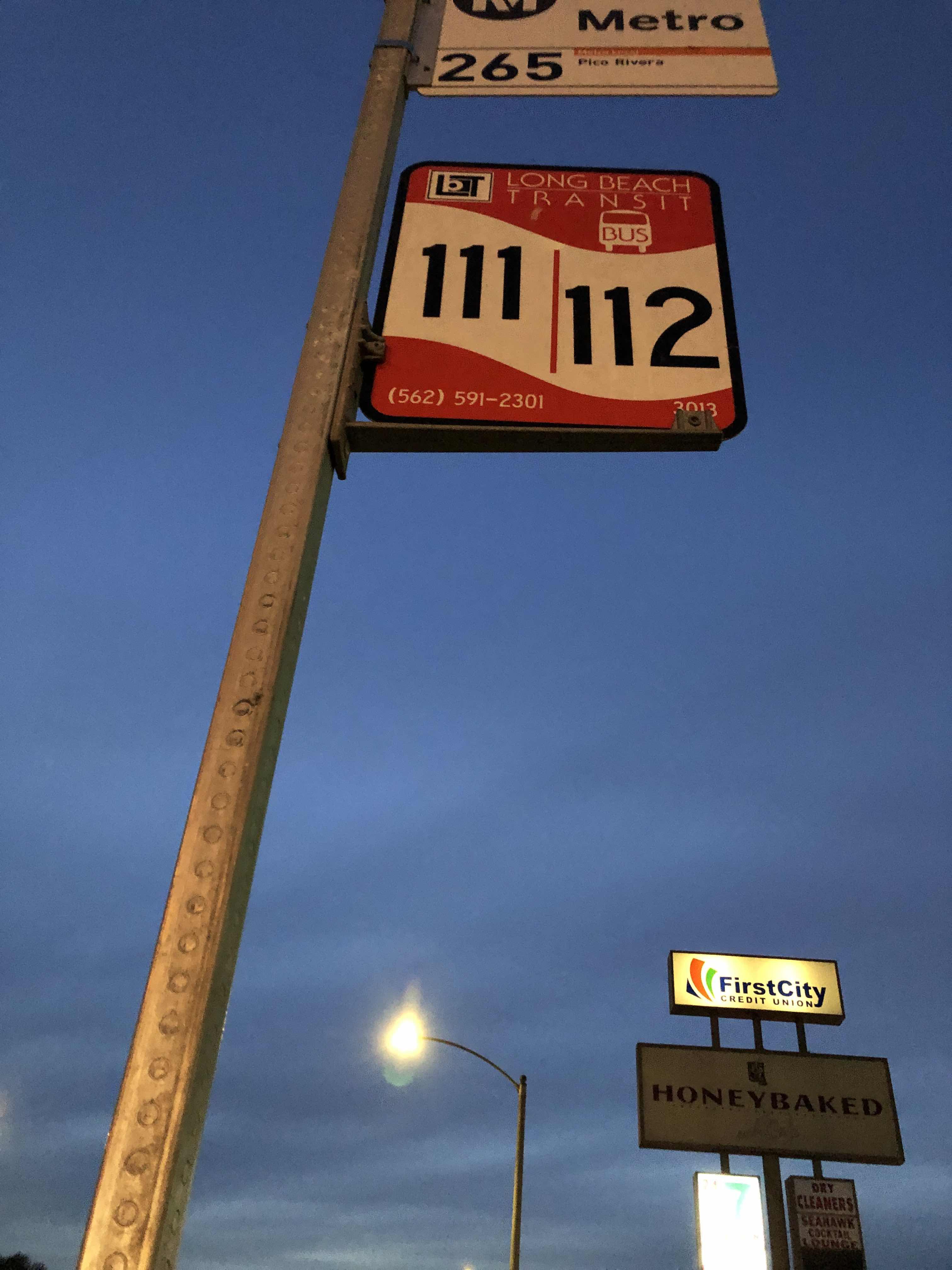
 Bus: 112, 192, 22, 265, 111.
How to get to Paramount & 55th Way E stop by bus?
Click on the bus route to see step by step directions with maps, line arrival times and updated time schedules.
Bus stops near Paramount & 55th Way E stop in Long Beach
- Paramount / 55th, 1 min walk,
- Paramount & Candlewood NE, 4 min walk,
- Candlewood / Paramount, 5 min walk,
- South & Paramount SE, 6 min walk,
Bus lines to Paramount & 55th Way E stop in Long Beach
- 265, Pico Rivera,
- 111, 111 Bdwy-Lkwd to South St via LB Airport,
- 112, 112 Bdwy-Clark to South St via LBCC,
- 22, 22 Downey Ave to Artesia Blvd Only,
- 192, 192 Santa Fe to Downtown Long Beach,
What are the closest stations to Paramount & 55th Way E?
The closest stations to Paramount & 55th Way E are:
- Paramount / 55th stop is 27 yards away, 1 min walk.
- Paramount & Candlewood NE stop is 340 yards away, 4 min walk.
- Candlewood / Paramount stop is 387 yards away, 5 min walk.
- South & Paramount SE stop is 442 yards away, 6 min walk.
Which bus lines stop near Paramount & 55th Way E?
These bus lines stop near Paramount & 55th Way E: 112, 192, 22, 265.
What’s the nearest bus station to Paramount & 55th Way E in Long Beach?
The nearest bus station to Paramount & 55th Way E in Long Beach is Paramount / 55th. It’s a 1 min walk away.
What time is the first bus to Paramount & 55th Way E in Long Beach?
The 192 is the first bus that goes to Paramount & 55th Way E in Long Beach. It stops nearby at 5:07 AM.
What time is the last bus to Paramount & 55th Way E in Long Beach?
The 22 is the last bus that goes to Paramount & 55th Way E in Long Beach. It stops nearby at 11:37 PM.
Paramount & 55th Way E station
 Taken by Anonymous
See Paramount & 55th Way E stop, Long Beach, on the map
Public transit to Paramount & 55th Way E stop (ID: 3057) in Long Beach
Looking for directions to Paramount & 55th Way E in Long Beach, United States?
Download the Moovit App to find the current schedule and step-by-step directions for Bus routes that pass through Paramount & 55th Way E.
Looking for the nearest stops closest to Paramount & 55th Way E ? Check out this list of closest stops to your destination: Paramount / 55th; Paramount & Candlewood NE; Candlewood / Paramount; South & Paramount SE.
Bus: 112, 192, 22, 265, 111.
We make riding on public transit to Paramount & 55th Way E easy, which is why over 1.7 billion users, including users in Long Beach trust Moovit as the best app for public transit.
Use the app to navigate to popular places including to the airport, hospital, stadium, grocery store, mall, coffee shop, school, college, and university.
Paramount & 55th Way E stop’s code is 3057
The first line to this stop is 111, at 5:52 AM, and the last line is 111 at 10:54 PM.
2696 E 55th Wy, Long Beach, CA, USA
This stop serves Long Beach Transit’s lines
- Paramount / 55th,
- Paramount & Candlewood NE,
- Candlewood / Paramount,
- South & Paramount SE
Bus stops near Paramount & 55th Way E stop
- Atlantic / Whittier,
- Florence / Centinela,
- Florence / Avalon,
- Alondra Blvd/Studebaker Rd SB,
- Las Virgenes Rd & 101 Fwy (Eastbound),
- Laurel Canyon / Vanowen,
- Sherman Way / Variel,
- Telegraph / Orr and Day,
- Cesar E Chavez / Gage,
- Wilshire / La Country Club,
- Victory / Tujunga,
- Bellflower & Atherton SW,
- MLK Blvd & Magic Johnson Theater,
- Willow & Long Beach Blvd SE,
- Compton Ave & Nadeau St (Northbound),
- Sunset / Western,
- Palmdale Blvd. & Sierra Hwy,
- 54th St & Vermont Ave (Eastbound),
- Centinela / Inglewood,
- Central / Olympic
Popular public transit stations in Long Beach
Get around Long Beach by public transit!
Traveling around Long Beach has never been so easy. See step by step directions as you travel to any attraction, street or major public transit station. View bus and train schedules, arrival times, service alerts and detailed routes on a map, so you know exactly how to get to anywhere in Long Beach.
When traveling to any destination around Long Beach use Moovit's Live Directions with Get Off Notifications to know exactly where and how far to walk, how long to wait for your line, and how many stops are left. Moovit will alert you when it's time to get off — no need to constantly re-check whether yours is the next stop.
Wondering how to use public transit in Long Beach or how to pay for public transit in Long Beach? Moovit public transit app can help you navigate your way with public transit easily, and at minimum cost. It includes public transit fees, ticket prices, and costs. Looking for a map of Long Beach public transit lines? Moovit public transit app shows all public transit maps in Long Beach with all Bus, Train, Subway, Ferry and Funicular routes and stops on an interactive map.
Los Angeles has 5 transit type(s), including: Bus, Train, Subway, Ferry and Funicular, operated by several transit agencies, including Metro, Metro Event Service, Alhambra Community Transit (ACT), Arcadia Transit, Artesia Transit, AVTA, Baldwin Park Transit, Beach Cities Transit, Beaumont Transit, Bell Gardens Town Trolley, Bellflower Bus, Big Blue Bus, Burbank Bus, Calabasas Trolley and Camarillo Area Transit