Passolombardo/Pantanella stop - Thursday schedule
| Line | Direction | Time |
|---|---|---|
| 506 | Anagnina Metro | 5:14 AM |
| 504 | Anagnina Metro | 5:35 AM |
| 506 | Anagnina Metro | 5:41 AM |
| 504 | Anagnina Metro | 5:57 AM |
| 506 | Anagnina Metro | 6:08 AM |
| 504 | Anagnina Metro | 6:18 AM |
| 506 | Anagnina Metro | 6:35 AM |
| 504 | Anagnina Metro | 6:43 AM |
| 506 | Anagnina Metro | 6:56 AM |
| 504 | Anagnina Metro | 7:06 AM |
| 506 | Anagnina Metro | 7:16 AM |
| 504 | Anagnina Metro | 7:30 AM |
| 506 | Anagnina Metro | 7:37 AM |
| 504 | Anagnina Metro | 7:51 AM |
| 506 | Anagnina Metro | 7:59 AM |
| 504 | Anagnina Metro | 8:12 AM |
| 506 | Anagnina Metro | 8:21 AM |
| 504 | Anagnina Metro | 8:32 AM |
| 506 | Anagnina Metro | 8:43 AM |
| 504 | Anagnina Metro | 8:53 AM |
| 506 | Anagnina Metro | 9:04 AM |
| 504 | Anagnina Metro | 9:13 AM |
| 506 | Anagnina Metro | 9:26 AM |
| 504 | Anagnina Metro | 9:33 AM |
| 504 | Anagnina Metro | 9:53 AM |
Directions to Passolombardo/Pantanella stop (Roma) with public transit
The following transit lines have routes that pass near Passolombardo/Pantanella
 Bus: 504, 506, 507, 552, COTRAL.
- Metro: C.
How to get to Passolombardo/Pantanella stop by bus?
Click on the bus route to see step by step directions with maps, line arrival times and updated time schedules.
Bus stops near Passolombardo/Pantanella stop in Roma
- Passolombardo/Pantanella, 2 min walk,
- Berkeley/Passolombardo, 2 min walk,
- Passolombardo/Cracovia, 5 min walk,
- Tor Vergata/Alessio, 5 min walk,
- Campus X/CLA Headquarters (Passolombardo Road), 8 min walk,
Metro stations near Passolombardo/Pantanella station in Roma
- Grotte Celoni, 20 min walk,
Bus lines to Passolombardo/Pantanella stop in Roma
- 506, Grotte Celoni,
- 504, Anagnina Metro,
- COTRAL, Colleferro Scalo - Roma Anagnina,
- COTRAL, Filettino - Roma Anagnina,
- COTRAL, Sora - Roma Anagnina,
- COTRAL, Genazzano - Roma Anagnina,
- COTRAL, Frosinone - Roma Anagnina,
- COTRAL, Roiate - Roma Anagnina,
- COTRAL, Rocca Santo Stefano - Roma Anagnina,
- COTRAL, Subiaco - Roma Anagnina,
- COTRAL, Guarcino - Roma Anagnina,
- COTRAL, Fiuggi - Roma Anagnina,
- COTRAL, Olevano Romano - Roma Anagnina,
- COTRAL, Veroli - Roma Anagnina,
- COTRAL, Alatri - Roma Anagnina,
- COTRAL, Carpineto Romano - Roma Anagnina,
- COTRAL, San Vito Romano - Roma Anagnina,
- 507, Grotte Celoni,
- 509, Anagnina Metro,
- 12, Ciampino Station,
What are the closest stations to Passolombardo/Pantanella?
The closest stations to Passolombardo/Pantanella are:
- Passolombardo/Pantanella stop is 95 meters away, 2 min walk.
- Berkeley/Passolombardo stop is 122 meters away, 2 min walk.
- Passolombardo/Cracovia stop is 317 meters away, 5 min walk.
- Tor Vergata/Alessio stop is 351 meters away, 5 min walk.
- Campus X/CLA Headquarters (Passolombardo Road) stop is 551 meters away, 8 min walk.
- Grotte Celoni station is 1559 meters away, 20 min walk.
Which bus lines stop near Passolombardo/Pantanella?
These bus lines stop near Passolombardo/Pantanella: 504, 506, 507, 552.
What’s the nearest metro station to Passolombardo/Pantanella in Roma?
The nearest metro station to Passolombardo/Pantanella in Roma is Grotte Celoni. It’s a 20 min walk away.
What’s the nearest bus station to Passolombardo/Pantanella in Roma?
The nearest bus stations to Passolombardo/Pantanella in Roma are Passolombardo/Pantanella and Berkeley/Passolombardo. The closest one is a 2 min walk away.
What time is the first metro to Passolombardo/Pantanella in Roma?
The C is the first metro that goes to Passolombardo/Pantanella in Roma. It stops nearby at 5:40 AM.
What time is the last metro to Passolombardo/Pantanella in Roma?
The C is the last metro that goes to Passolombardo/Pantanella in Roma. It stops nearby at 11:57 PM.
What time is the first bus to Passolombardo/Pantanella in Roma?
The 507 is the first bus that goes to Passolombardo/Pantanella in Roma. It stops nearby at 4:43 AM.
What time is the last bus to Passolombardo/Pantanella in Roma?
The 506 is the last bus that goes to Passolombardo/Pantanella in Roma. It stops nearby at 12:45 AM.
Passolombardo/Pantanella station
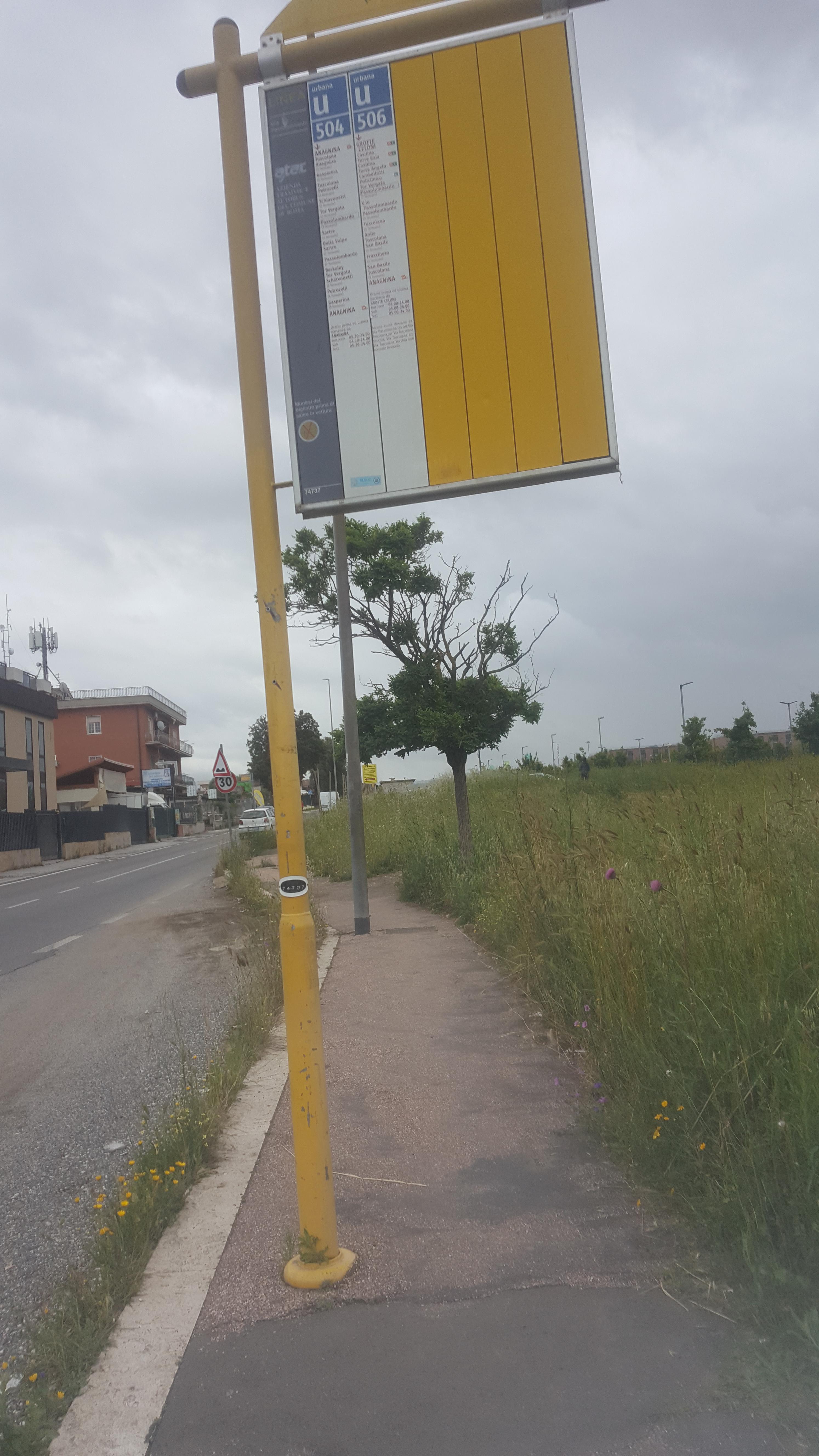 Taken by Anonymous
See Passolombardo/Pantanella stop, Roma, on the map
Public transit to Passolombardo/Pantanella stop (ID: 74737) in Roma
Looking for directions to Passolombardo/Pantanella in Roma, Italy?
Download the Moovit App to find the current schedule and step-by-step directions for Bus or Metro routes that pass through Passolombardo/Pantanella.
Looking for the nearest stops closest to Passolombardo/Pantanella ? Check out this list of closest stops to your destination: Passolombardo/Pantanella; Berkeley/Passolombardo; Passolombardo/Cracovia; Tor Vergata/Alessio; Campus X/CLA Headquarters (Passolombardo Road); Grotte Celoni.
Bus: 504, 506, 507, 552, COTRAL, COTRAL, COTRAL, COTRAL, COTRAL, 509, 12.Metro: C.
We make riding on public transit to Passolombardo/Pantanella easy, which is why over 1.7 billion users, including users in Roma trust Moovit as the best app for public transit.
Use the app to navigate to popular places including to the airport, hospital, stadium, grocery store, mall, coffee shop, school, college, and university.
Passolombardo/Pantanella stop’s code is 74737
The first line to this stop is 506, at 5:14 AM, and the last line is 504 at 12:20 AM.
Via Gianni Brera, Roma, Italy
This stop serves ATAC’s lines
- Passolombardo/Pantanella,
- Berkeley/Passolombardo,
- Passolombardo/Cracovia,
- Tor Vergata/Alessio,
- Campus X/CLA Headquarters (Passolombardo Road)
Bus stops near Passolombardo/Pantanella stop
- Grotte Celoni
Metro station near Passolombardo/Pantanella station
- Modern Art Gallery,
- Cassia/Giustiniana,
- Parioli/Santiago Del Cile,
- Repubblica (Metro A),
- Goito/XX September,
- Chestnuts Street, 136,
- Guglielmo Marconi Avenue, 38,
- Cortina D'Ampezzo/Cavalese,
- Cerveteri | Marina Di Cerveteri Station,
- Frascati | S. Sebastiano Hospital,
- Bufalotta/Albertazzi,
- Veneto/Sardegna,
- Pomezia | Via Del Mare (La Macchiozza),
- Cavalleggeri/San Pietro,
- Portuense/Imbrecciato,
- Rome | Salaria Road (Quattro Cancelli),
- Coastal Road/Gate 3,
- Frosinone | I.I.S. Turriziani,
- Crescenzio/Risorgimento,
- New Church
Popular public transit stations in Roma
Get around Roma by public transit!
Traveling around Roma has never been so easy. See step by step directions as you travel to any attraction, street or major public transit station. View bus and train schedules, arrival times, service alerts and detailed routes on a map, so you know exactly how to get to anywhere in Roma.
When traveling to any destination around Roma use Moovit's Live Directions with Get Off Notifications to know exactly where and how far to walk, how long to wait for your line, and how many stops are left. Moovit will alert you when it's time to get off — no need to constantly re-check whether yours is the next stop.
Wondering how to use public transit in Roma or how to pay for public transit in Roma? Moovit public transit app can help you navigate your way with public transit easily, and at minimum cost. It includes public transit fees, ticket prices, and costs. Looking for a map of Roma public transit lines? Moovit public transit app shows all public transit maps in Roma with all Bus, Train, Metro, Light Rail, Ferry, Funicular and Gondola routes and stops on an interactive map.
Rome and Lazio has 7 transit type(s), including: Bus, Train, Metro, Light Rail, Ferry, Funicular and Gondola, operated by several transit agencies, including ATAC, Cotral, Trenitalia, Troiani Transportation Services, BIS, ATR Mobility, Tuscia, Shuttle, Seatour, Troiani Bus Lines, CSC Mobility, Terravision, ATRAL, Tambus and Sitbus