Pearse Station, Pearse Street stop - Monday schedule
| Line | Direction | Time |
|---|---|---|
| C2 | Sandymount | 3:06 AM |
| C5 | Ringsend Road | 3:29 AM |
| C1 | Sandymount | 3:33 AM |
| C1 | Sandymount | 3:36 AM |
| C6 | Ringsend Road | 3:49 AM |
| C2 | Sandymount | 4:12 AM |
| C5 | Ringsend Road | 4:25 AM |
| C1 | Sandymount | 4:40 AM |
| C6 | Ringsend Road | 4:51 AM |
| C2 | Sandymount | 5:12 AM |
| C3 | Ringsend Road | 5:19 AM |
| C1 | Sandymount | 5:27 AM |
| C4 | Ringsend Road | 5:46 AM |
| C2 | Sandymount | 6:04 AM |
| C3 | Ringsend Road | 6:08 AM |
| 52 | Ringsend Road | 6:18 AM |
| C1 | Sandymount | 6:38 AM |
| C2 | Sandymount | 6:44 AM |
| C4 | Ringsend Road | 6:46 AM |
| C1 | Sandymount | 6:53 AM |
| C2 | Sandymount | 6:59 AM |
| C1 | Sandymount | 7:08 AM |
| C2 | Sandymount | 7:12 AM |
| C3 | Ringsend Road | 7:14 AM |
| 56A | Ringsend Road | 7:14 AM |
Directions to Pearse Station, Pearse Street (Dublin) with public transportation
The following transit lines have routes that pass near Pearse Station, Pearse Street
How to get to Pearse Station, Pearse Street by bus?
Click on the bus route to see step by step directions with maps, line arrival times and updated time schedules.
How to get to Pearse Station, Pearse Street by train?
Click on the train route to see step by step directions with maps, line arrival times and updated time schedules.
Bus stops near Pearse Station, Pearse Street in Dublin
- Erne Street, 1 min walk,
- Grand Canal Dock, Pearse Square, 3 min walk,
- Pearse Street, 5 min walk,
- Pearse Station, 5 min walk,
- Westland Row, 6 min walk,
- Prince's Street South, 6 min walk,
- Westland Row Church, 6 min walk,
Train station near Pearse Station, Pearse Street in Dublin
- Dublin Pearse, 2 min walk,
Bus lines to Pearse Station, Pearse Street in Dublin
- C1, Adamstown Station,
- C2, Adamstown Station,
- C3, Maynooth,
- C4, Maynooth,
- C5, Maynooth,
- C6, Maynooth,
- 27, Jobstown,
- P29, Adamstown Station,
- 47, Poolbeg St,
- 52, Leixlip Intel,
- 56A, The Square,
- 77A, Citywest,
- DUBLIN CITY SOUTH, D'OLIER STREET - CHARLESLAND ROAD (SEABORNE VIEW APTS), Charlesland,
- 720, Out Of Service Cw,
- 4, Heuston Station,
- 7, Mountjoy Square,
- 7A, Parnell Square,
- 7E, Mountjoy Square,
- 15A, Limekiln Ave,
- 15B, Stocking Ave,
What are the closest stations to Pearse Station, Pearse Street?
The closest stations to Pearse Station, Pearse Street are:
- Erne Street is 8 meters away, 1 min walk.
- Dublin Pearse is 138 meters away, 2 min walk.
- Grand Canal Dock, Pearse Square is 190 meters away, 3 min walk.
- Pearse Street is 338 meters away, 5 min walk.
- Pearse Station is 351 meters away, 5 min walk.
- Westland Row is 389 meters away, 6 min walk.
- Prince's Street South is 407 meters away, 6 min walk.
- Westland Row Church is 440 meters away, 6 min walk.
Which bus lines stop near Pearse Station, Pearse Street?
These bus lines stop near Pearse Station, Pearse Street: 77A, 7A, C2, C3, C4, N4.
Which train line stops near Pearse Station, Pearse Street?
DART (Bray (Daly)→Malahide)
What’s the nearest train station to Pearse Station, Pearse Street in Dublin?
The nearest train station to Pearse Station, Pearse Street in Dublin is Dublin Pearse. It’s a 2 min walk away.
What’s the nearest bus station to Pearse Station, Pearse Street in Dublin?
The nearest bus station to Pearse Station, Pearse Street in Dublin is Erne Street. It’s a 1 min walk away.
What time is the first light rail to Pearse Station, Pearse Street in Dublin?
The RED is the first light rail that goes to Pearse Station, Pearse Street in Dublin. It stops nearby at 7:04 AM.
What time is the last light rail to Pearse Station, Pearse Street in Dublin?
The RED is the last light rail that goes to Pearse Station, Pearse Street in Dublin. It stops nearby at 11:44 PM.
What time is the first train to Pearse Station, Pearse Street in Dublin?
The DART is the first train that goes to Pearse Station, Pearse Street in Dublin. It stops nearby at 9:01 AM.
What time is the last train to Pearse Station, Pearse Street in Dublin?
The DART is the last train that goes to Pearse Station, Pearse Street in Dublin. It stops nearby at 12:13 AM.
What time is the first bus to Pearse Station, Pearse Street in Dublin?
The C6 is the first bus that goes to Pearse Station, Pearse Street in Dublin. It stops nearby at 3:07 AM.
What time is the last bus to Pearse Station, Pearse Street in Dublin?
The 785 is the last bus that goes to Pearse Station, Pearse Street in Dublin. It stops nearby at 5:20 AM.
Pearse Station, Pearse Street station
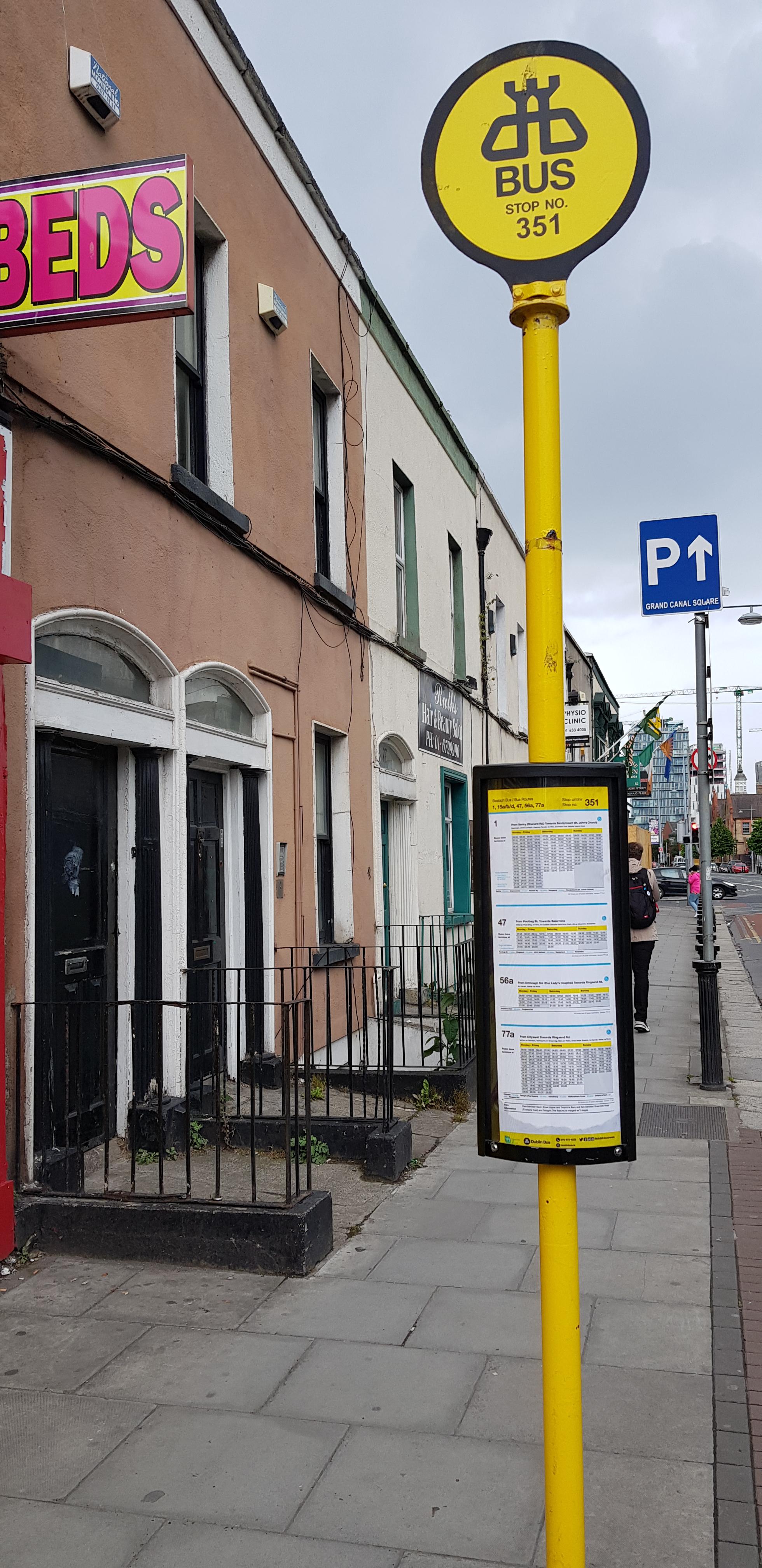 Taken by David E.
See Pearse Station, Pearse Street, Dublin, on the map
Public transit to Pearse Station, Pearse Street stop (ID: 351) in Dublin
Looking for directions to Pearse Station, Pearse Street in Dublin, Ireland?
Download the Moovit App to find the current schedule and step-by-step directions for Bus or Train routes that pass through Pearse Station, Pearse Street.
Looking for the nearest stops closest to Pearse Station, Pearse Street ? Check out this list of closest stops to your destination: Erne Street; Dublin Pearse; Grand Canal Dock; Pearse Street; Pearse Station; Westland Row; Prince's Street South; Westland Row Church.
Bus: 77A, 7A, C2, C3, C4, N4, C1, C5, DUBLIN CITY SOUTH, D'OLIER STREET - CHARLESLAND ROAD (SEABORNE VIEW APTS), 720, 4, 7, 7E, 15A, 193, 194, 785, 193, 194.Train: DART, COMMUTER, RAIL, RAIL, RAIL.
We make riding on public transit to Pearse Station, Pearse Street easy, which is why over 1.5 million users, including users in Dublin trust Moovit as the best app for public transit.
Use the app to navigate to popular places including to the airport, hospital, stadium, grocery store, mall, coffee shop, school, college, and university.
Pearse Station, Pearse Street stop’s code is 351
The first line to this stop is C2, at 3:06 AM, and the last line is C6 at 2:45 AM.
76 Pearse Street, Dublin, Ireland
This stop serves Bus Átha Cliath – Dublin Bus and Nitelink, Dublin Bus’s lines
Bus stops near Pearse Station, Pearse Street
Train station near Pearse Station, Pearse Street
Popular public transit stations in Dublin
Get around Dublin by public transit!
Traveling around Dublin has never been so easy. See step by step directions as you travel to any attraction, street or major public transit station. View bus and train schedules, arrival times, service alerts and detailed routes on a map, so you know exactly how to get to anywhere in Dublin.
When traveling to any destination around Dublin use Moovit's Live Directions with Get Off Notifications to know exactly where and how far to walk, how long to wait for your line, and how many stops are left. Moovit will alert you when it's time to get off — no need to constantly re-check whether yours is the next stop.
Wondering how to use public transit in Dublin or how to pay for public transit in Dublin? Moovit public transit app can help you navigate your way with public transit easily, and at minimum cost. It includes public transit fees, ticket prices, and costs. Looking for a map of Dublin public transit lines? Moovit public transit app shows all public transit maps in Dublin with all Bus, Train and Light Rail routes and stops on an interactive map.
Ireland has 3 transit type(s), including: Bus, Train and Light Rail, operated by several transit agencies, including Luas, Bus Átha Cliath – Dublin Bus, Bus Éireann, Go-Ahead Ireland, Nitelink, Dublin Bus, Citylink, City Direct, Kenneally's Bus Service, Aircoach, TFI Local Link Mayo, Irish Rail, Express Bus, JJ/Bernard Kavanagh, Dublin Coach and Kearns Transport