Directions to Phillips Collection (Washington) with public transportation
The following transit lines have routes that pass near Phillips Collection
 Bus: 325, C51, C91, D72, D74.
- Train: MANASSAS LINE, MARC.
- Metro: RED, BLUE, ORANGE, SILVER.
How to get to Phillips Collection by bus?
Click on the bus route to see step by step directions with maps, line arrival times and updated time schedules.
How to get to Phillips Collection by train?
Click on the train route to see step by step directions with maps, line arrival times and updated time schedules.
How to get to Phillips Collection by metro?
Click on the metro route to see step by step directions with maps, line arrival times and updated time schedules.
Bus stops near Phillips Collection in Washington
- Massachusetts Av Nw+Florida Av NW, 3 min walk,
- P St Nw+21 St NW, 4 min walk,
- Washington Dc (Dupont Circle), 4 min walk,
- Massachusetts Av Nw+20 St NW, 4 min walk,
- Q St Nw+22 St NW, 4 min walk,
- Connecticut Av Nw+R St NW, 4 min walk,
Metro stations near Phillips Collection in Washington
- Dupont Circle Metro Station, 11 min walk,
- Farragut West, 16 min walk,
Bus lines to Phillips Collection in Washington
- D74, East To Rhode Island Av,
- D90, West To Tenleytown,
- C91, East To Ledroit Park,
- FLIXBUS 2601, New York (Hudson Yards),
- D96, South To Potomac Park,
- D94, East To Gallery Place,
- D70, South To Farragut Sq,
- D72, North To Mt Pleasant,
What are the closest stations to Phillips Collection?
The closest stations to Phillips Collection are:
- Massachusetts Av Nw+Florida Av NW is 196 yards away, 3 min walk.
- P St Nw+21 St NW is 242 yards away, 4 min walk.
- Washington Dc (Dupont Circle) is 256 yards away, 4 min walk.
- Massachusetts Av Nw+20 St NW is 262 yards away, 4 min walk.
- Q St Nw+22 St NW is 273 yards away, 4 min walk.
- Connecticut Av Nw+R St NW is 304 yards away, 4 min walk.
- Dupont Circle Metro Station is 852 yards away, 11 min walk.
- Farragut West is 1295 yards away, 16 min walk.
Which bus lines stop near Phillips Collection?
These bus lines stop near Phillips Collection: 325, C51, C91, D72, D74, D90.
Which train lines stop near Phillips Collection?
These train lines stop near Phillips Collection: MANASSAS LINE, MARC.
Which metro line stops near Phillips Collection?
RED (Shady Grove)
What’s the nearest metro station to Phillips Collection in Washington?
The nearest metro station to Phillips Collection in Washington is Dupont Circle Metro Station. It’s a 11 min walk away.
What’s the nearest bus station to Phillips Collection in Washington?
The nearest bus station to Phillips Collection in Washington is Massachusetts Av Nw+Florida Av NW. It’s a 3 min walk away.
What time is the first metro to Phillips Collection in Washington?
The BLUE is the first metro that goes to Phillips Collection in Washington. It stops nearby at 5:24 AM.
What time is the last metro to Phillips Collection in Washington?
The RED is the last metro that goes to Phillips Collection in Washington. It stops nearby at 12:12 AM.
What time is the first bus to Phillips Collection in Washington?
The D72 is the first bus that goes to Phillips Collection in Washington. It stops nearby at 4:18 AM.
What time is the last bus to Phillips Collection in Washington?
The FLIXBUS 2601 is the last bus that goes to Phillips Collection in Washington. It stops nearby at 2:40 AM.
See Phillips Collection, Washington, on the map
Public Transit to Phillips Collection in Washington
Wondering how to get to Phillips Collection in Washington? Moovit helps you find the best way to get to Phillips Collection with step-by-step directions from the nearest public transit station.
Moovit provides free maps and live directions to help you navigate through your city. View schedules, routes, timetables, and find out how long does it take to get to Phillips Collection in real time.
Looking for the nearest stop or station to Phillips Collection? Check out this list of stops closest to your destination: Massachusetts Av Nw+Florida Av NW; P St Nw+21 St NW; Washington Dc (Dupont Circle); Massachusetts Av Nw+20 St NW; Q St Nw+22 St NW; Connecticut Av Nw+R St NW; Dupont Circle Metro Station; Farragut West.
Bus: 325, C51, C91, D72, D74, D90, FLIXBUS 2601, D96.Train: MANASSAS LINE, MARC.Metro: RED, BLUE, ORANGE, SILVER.
Want to see if there’s another route that gets you there at an earlier time? Moovit helps you find alternative routes or times. Get directions from and directions to Phillips Collection easily from the Moovit App or Website.
We make riding to Phillips Collection easy, which is why over 1.5 million users, including users in Washington, trust Moovit as the best app for public transit. You don’t need to download an individual bus app or train app, Moovit is your all-in-one transit app that helps you find the best bus time or train time available.
For information on prices of metro, bus and train, costs and ride fares to Phillips Collection, please check the Moovit app.
Use the app to navigate to popular places including to the airport, hospital, stadium, grocery store, mall, coffee shop, school, college, and university.
Location: Washington, Washington, D.C. - Baltimore, MD
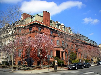
- The Phillips Collection,
- Embassy of India,
- Larz Anderson House,
- Cosmos Club,
- Stay BNB DC,
- The Embassy Row Hotel,
- Embassy of the Republic of Indonesia,
- Annabelle,
- Zorba's Cafe,
- Embassy of The Republic of Mali,
- Polish Consulate,
- Dupont Circle,
- Dupont Circle Q Street Exit,
- Embassy Of Bulgaria,
- Q St NW (20th and Q St NW),
- Embassy of Colombia,
- Statue of Goddess Dewi Saraswati,
- Embassy Of Portugal,
- Dupont Circle Metro (North Q St. Entrance);Dupont Circle,
- Pizzeria Paradiso
Places Near Phillips Collection (Washington)
- Museum Of The Bible, Washington,
- National Zoo, Washington,
- Basilica of the National Shrine, Washington,
- Westfield Montgomery Mall, Montgomery County,
- The Anthem, Washington,
- Georgetown, Washington,
- Amazon Hq2, Arlington County,
- White House, Washington,
- National Museum of African American History and Culture, Washington,
- M&T Bank Stadium, Baltimore,
- Washington National Cathedral, Washington,
- Capital One Arena, Washington,
- National Mall, Washington,
- Sibley Memorial Hospital, Washington,
- Camden Yards, Baltimore,
- Warner Theatre, Washington,
- Washington Monument, Washington,
- Marriott Marquis Washington, DC, Washington,
- 14th Street NW, Washington,
- Washington DC VA Medical Center, Washington
How to get to popular places in Washington, D.C. - Baltimore, MD with public transit
Get around Washington by public transit!
Traveling around Washington has never been so easy. See step by step directions as you travel to any attraction, street or major public transit station. View bus and train schedules, arrival times, service alerts and detailed routes on a map, so you know exactly how to get to anywhere in Washington.
When traveling to any destination around Washington use Moovit's Live Directions with Get Off Notifications to know exactly where and how far to walk, how long to wait for your line, and how many stops are left. Moovit will alert you when it's time to get off — no need to constantly re-check whether yours is the next stop.
Wondering how to use public transit in Washington or how to pay for public transit in Washington? Moovit public transit app can help you navigate your way with public transit easily, and at minimum cost. It includes public transit fees, ticket prices, and costs. Looking for a map of Washington public transit lines? Moovit public transit app shows all public transit maps in Washington with all Bus, Train, Metro, Light Rail and Ferry routes and stops on an interactive map.
Washington, D.C. - Baltimore, MD has 5 transit type(s), including: Bus, Train, Metro, Light Rail and Ferry, operated by several transit agencies, including WMATA, Montgomery County Ride On, Fairfax Connector, TheBus, PRTC, DASH - Alexandria, Arlington Transit (ART), DC Streetcar, RTA of Central Maryland, FXBGO!, MDOT MTA, Marc, Virginia Railway Express (VRE), University of Maryland Shuttle-UM and CUE Bus - City of Fairfax