Directions to Pont D'Arcole (Paris) with public transportation
The following transit lines have routes that pass near Pont D'Arcole
 Bus: 38, 72, 74, 76, 85.
- Metro: 1, 11, 14, 4, 7.
- RER: B, C.
How to get to Pont D'Arcole by bus?
Click on the bus route to see step by step directions with maps, line arrival times and updated time schedules.
How to get to Pont D'Arcole by metro?
Click on the metro route to see step by step directions with maps, line arrival times and updated time schedules.
Metro stations near Pont D'Arcole in Paris
- Pont Marie (Cité Des Arts), 1 min walk,
- Châtelet, 4 min walk,
Bus stops near Pont D'Arcole in Paris
- Châtelet, 4 min walk,
- Cité - Parvis Notre-Dame, 4 min walk,
- Hôtel de Ville, 4 min walk,
- Châtelet - Quai de Gesvres, 4 min walk,
- Châtelet / Coutellerie, 5 min walk,
RER station near Pont D'Arcole in Paris
- Saint-Michel Notre-Dame, 7 min walk,
Bus lines to Pont D'Arcole in Paris
- N22, Châtelet,
- 47, Fort du Kremlin-Bicêtre,
- 75, Porte de Pantin,
- N15, Villejuif - Louis Aragon,
- 70, Porte de Passy,
- N11, Pont de Neuilly-Métro,
- N16, Pont de Levallois - Bécon,
- N21, Châtelet,
- 67, Palais Royal - Musée du Louvre,
- 69, Champ de Mars,
- 72, Gare de Lyon - Maison de la Ratp,
- 58, Châtelet,
- 96, Porte Des Lilas,
- N24, La Défense (Voie Perronet Nord),
- 76, Montreuil - Hôpital,
- 38, Porte D'Orléans,
- N23, Châtelet / Coutellerie,
- N12, Porte de Saint-Cloud,
- N13, Mairie D'Issy,
- N123, Gare D'Arpajon,
What are the closest stations to Pont D'Arcole?
The closest stations to Pont D'Arcole are:
- Pont Marie (Cité Des Arts) is 22 meters away, 1 min walk.
- Châtelet is 235 meters away, 4 min walk.
- Cité - Parvis Notre-Dame is 260 meters away, 4 min walk.
- Hôtel de Ville is 290 meters away, 4 min walk.
- Châtelet - Quai de Gesvres is 296 meters away, 4 min walk.
- Châtelet / Coutellerie is 340 meters away, 5 min walk.
- Saint-Michel Notre-Dame is 508 meters away, 7 min walk.
Which bus lines stop near Pont D'Arcole?
These bus lines stop near Pont D'Arcole: 38, 72, 74, 76, 85.
Which metro lines stop near Pont D'Arcole?
These metro lines stop near Pont D'Arcole: 1, 11, 14, 4, 7.
Which RER lines stop near Pont D'Arcole?
These RER lines stop near Pont D'Arcole: B, C.
What’s the nearest metro station to Pont D'Arcole in Paris?
The nearest metro station to Pont D'Arcole in Paris is Pont Marie (Cité Des Arts). It’s a 1 min walk away.
What’s the nearest bus station to Pont D'Arcole in Paris?
The nearest bus stations to Pont D'Arcole in Paris are Châtelet, Cité - Parvis Notre-Dame, Hôtel de Ville and Châtelet - Quai de Gesvres. The closest one is a 4 min walk away.
What’s the nearest RER station to Pont D'Arcole in Paris?
The nearest RER station to Pont D'Arcole in Paris is Saint-Michel Notre-Dame. It’s a 7 min walk away.
What time is the first metro to Pont D'Arcole in Paris?
The 14 is the first metro that goes to Pont D'Arcole in Paris. It stops nearby at 5:30 AM.
What time is the last metro to Pont D'Arcole in Paris?
The 11 is the last metro that goes to Pont D'Arcole in Paris. It stops nearby at 1:15 AM.
What time is the first bus to Pont D'Arcole in Paris?
The N24 is the first bus that goes to Pont D'Arcole in Paris. It stops nearby at 3:00 AM.
What time is the last bus to Pont D'Arcole in Paris?
The N22 is the last bus that goes to Pont D'Arcole in Paris. It stops nearby at 4:06 AM.
What time is the first RER to Pont D'Arcole in Paris?
The C is the first RER that goes to Pont D'Arcole in Paris. It stops nearby at 5:18 AM.
What time is the last RER to Pont D'Arcole in Paris?
The B is the last RER that goes to Pont D'Arcole in Paris. It stops nearby at 12:52 AM.
See Pont D'Arcole, Paris, on the map
Public Transit to Pont D'Arcole in Paris
How to get to Pont D'Arcole in Paris, France?
It’s easy with Moovit. Type in your street address and Moovit’s route finder will locate the fastest way to get you there! Not sure where to get off on the street? Download the Moovit App to find live directions (including where to get off on Pont D'Arcole), see timetables and get the estimated arrival times for your favorite metro, bus or RER lines.
Looking for the nearest stop or station to Pont D'Arcole? Check out this list of closest stops available to your destination: Pont Marie (Cité Des Arts); Châtelet; Cité - Parvis Notre-Dame; Hôtel de Ville; Châtelet - Quai de Gesvres; Châtelet / Coutellerie; Saint-Michel Notre-Dame.
Bus: 38, 72, 74, 76, 85, N22, 47, 75, N15, 70, N11, N16, N21.Metro: 1, 11, 14, 4, 7.RER: B, C.
Download the Moovit App to see the current schedule and routes available for Paris. No need to install a special bus app to check the bus time or a train app to get train time. Moovit is the only all-in-one transit app that helps you get where you need to go.
We make riding on public transit to Pont D'Arcole easy, which is why over 1.5 million users, including users in Paris trust Moovit as the best app for public transit.
Use the app to navigate to popular places including to the airport, hospital, stadium, grocery store, mall, coffee shop, school, college, and university.
Location: Paris
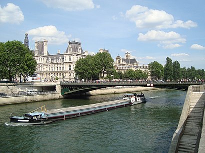
The Pont d'Arcole is a bridge in Paris over the River Seine. It is served by the Metro station Hôtel de Ville.Wiki
- Rue D'Arcole, Paris,
- Rue de la Colombe, Paris,
- Rue Des Ursins, Paris,
- Quai de L'Hôtel de Ville, Paris,
- Quai Aux Fleurs, Paris,
- Rue de Lobau, Paris,
- Rue de la Cité, Paris,
- Rue Chanoinesse, Paris,
- Parc Rives de Seine - Georges Pompidou, Paris,
- Accès Parking de L'Hôtel de Ville, Paris,
- Rue Des Chantres, Paris,
- Entrée du Parking de L'Hôtel de Ville, Paris,
- Rue du Cloître Notre-Dame, Paris,
- Pont Notre-Dame, Paris,
- Parvis Notre-Dame - Place Jean-Paul II, Paris,
- Avenue Victoria, Paris,
- Rue Massillon, Paris,
- Allée Celestin Hennion, Paris,
- Rue Aubé, Paris,
- Accès Parking Notre-Dame, Paris
Streets near Pont D'Arcole, Paris
Get around Paris by public transit!
Traveling around Paris has never been so easy. See step by step directions as you travel to any attraction, street or major public transit station. View bus and train schedules, arrival times, service alerts and detailed routes on a map, so you know exactly how to get to anywhere in Paris.
When traveling to any destination around Paris use Moovit's Live Directions with Get Off Notifications to know exactly where and how far to walk, how long to wait for your line, and how many stops are left. Moovit will alert you when it's time to get off — no need to constantly re-check whether yours is the next stop.
Wondering how to use public transit in Paris or how to pay for public transit in Paris? Moovit public transit app can help you navigate your way with public transit easily, and at minimum cost. It includes public transit fees, ticket prices, and costs. Looking for a map of Paris public transit lines? Moovit public transit app shows all public transit maps in Paris with all Bus, Train, Metro, Light Rail, RER and Funicular routes and stops on an interactive map.
Paris has 6 transit type(s), including: Bus, Train, Metro, Light Rail, RER and Funicular, operated by several transit agencies, including RATP, RER, RER Bus de remplacement, Train, Train Bus de remplacement, TER, Tramway, ADP, Magical Shuttle, Argenteuil - Boucles de Seine, Autocars Dominique, Bièvre, Brie et 2 Morin, Le Bus - C.C. du Clermontois and Cœur d’Essonne