Ponto Final - Taquara (Praça Figueira) - Wednesday schedule
| Line | Direction | Time |
|---|---|---|
| 341 | Candelária | 4:30 AM |
| 338 | Candelária | 5:00 AM |
| 341 | Candelária | 5:00 AM |
| 338 | Candelária | 5:30 AM |
| 341 | Candelária | 5:30 AM |
| 338 | Candelária | 6:00 AM |
| 341 | Candelária | 6:00 AM |
| 338 | Candelária | 6:30 AM |
| 341 | Candelária | 6:30 AM |
| 341 | Candelária | 7:00 AM |
| 341 | Taquara | 7:10 AM |
| 341 | Candelária | 7:30 AM |
| 341 | Taquara | 7:40 AM |
| 338 | Taquara | 7:45 AM |
| 341 | Candelária | 8:00 AM |
| 341 | Taquara | 8:10 AM |
| 338 | Taquara | 8:15 AM |
| 341 | Candelária | 8:30 AM |
| 341 | Taquara | 8:40 AM |
| 341 | Candelária | 9:00 AM |
| 341 | Taquara | 9:10 AM |
| 341 | Candelária | 9:30 AM |
| 341 | Taquara | 9:40 AM |
| 341 | Candelária | 10:00 AM |
| 341 | Taquara | 10:10 AM |
Directions to Ponto Final - Taquara (Praça Figueira) with public transportation
The following transit lines have routes that pass near Ponto Final - Taquara (Praça Figueira)
 Bus: 341, 600, SN 600, 2112, 338.
How to get to Ponto Final - Taquara (Praça Figueira) by bus?
Click on the bus route to see step by step directions with maps, line arrival times and updated time schedules.
Bus stops near Ponto Final - Taquara (Praça Figueira)
- Estrada Meringuava, 471-475, 2 min walk,
- Estr. Do Tindiba | Praça Jauru, 5 min walk,
- Av. Dos Mananciais | Praça Jauru, 6 min walk,
- Prezunic - Praça Jauru, 7 min walk,
- Estrada Do Rio Grande, 1162-1270, 14 min walk,
Bus lines to Ponto Final - Taquara (Praça Figueira)
- 600, Saens Peña (Ⓜ️ S. Fco. Xavier),
- SN 600, Taquara (Boiúna),
- 2112, Taquara,
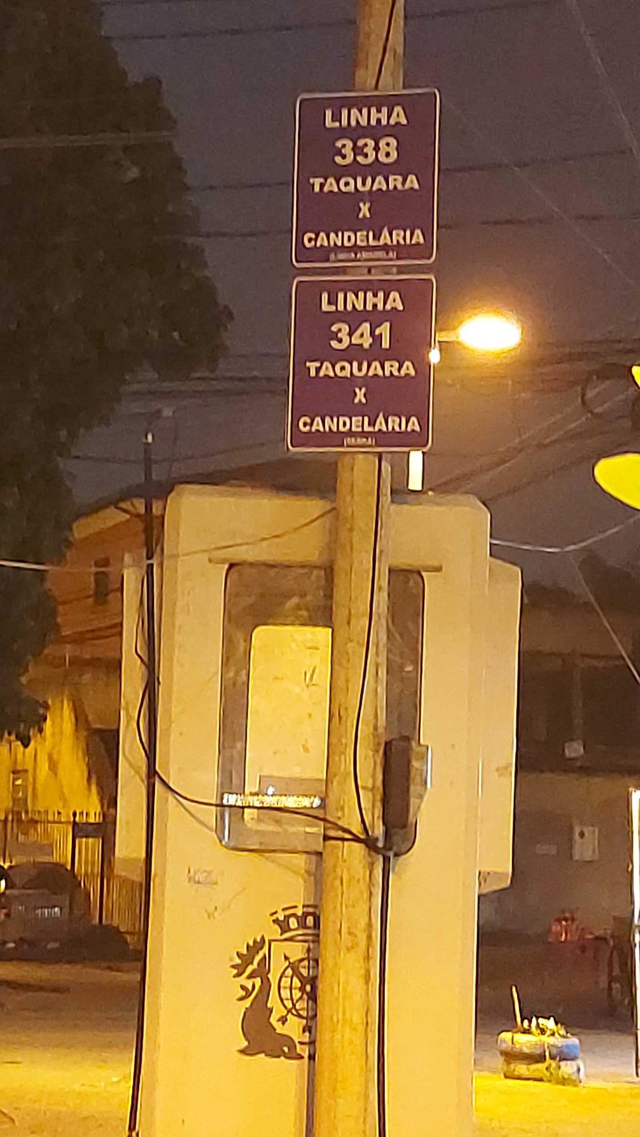
- 338, Taquara - Candelária (Brs 5 - Via Linha Amarela),
- 341, Taquara - Candelária (Brs 5 - Via Maracanã),
- 601, Santa Maria (Capela),
- SP 601, Hospital Cardoso Fontes,
- 434L, Nova Iguaçu - Taquara (via Vila Militar / Sulacap),
- 801, Bangu Shopping - Taquara / Merck (Via Jardim Novo),
- 803, Jabour - Taquara (via Bangu Shopping),
- SN 803, Jabour - Taquara (via Bangu Shopping),
- 865, Taquara,
What are the closest stations to Ponto Final - Taquara (Praça Figueira)?
The closest stations to Ponto Final - Taquara (Praça Figueira) are:
- Estrada Meringuava, 471-475 stop is 69 meters away, 2 min walk.
- Estr. Do Tindiba | Praça Jauru stop is 342 meters away, 5 min walk.
- Av. Dos Mananciais | Praça Jauru stop is 427 meters away, 6 min walk.
- Prezunic - Praça Jauru stop is 479 meters away, 7 min walk.
- Estrada Do Rio Grande, 1162-1270 stop is 1031 meters away, 14 min walk.
Which bus lines stop near Ponto Final - Taquara (Praça Figueira)?
These bus lines stop near Ponto Final - Taquara (Praça Figueira): 341, 600.
What’s the nearest bus station to Ponto Final - Taquara (Praça Figueira)?
The nearest bus station to Ponto Final - Taquara (Praça Figueira) is Estrada Meringuava, 471-475. It’s a 2 min walk away.
What time is the first bus to Ponto Final - Taquara (Praça Figueira)?
The 803 is the first bus that goes to Ponto Final - Taquara (Praça Figueira). It stops nearby at 3:06 AM.
What time is the last bus to Ponto Final - Taquara (Praça Figueira)?
The SN 600 is the last bus that goes to Ponto Final - Taquara (Praça Figueira). It stops nearby at 3:51 AM.
Ponto Final - Taquara (Praça Figueira)
 Taken by Lew A.
See Ponto Final - Taquara (Praça Figueira) on the map
Public transit to Ponto Final - Taquara (Praça Figueira)
Looking for directions to Ponto Final - Taquara (Praça Figueira) in Taquara, Brazil?
Download the Moovit App to find the current schedule and step-by-step directions for Bus routes that pass through Ponto Final - Taquara (Praça Figueira).
Looking for the nearest stops closest to Ponto Final - Taquara (Praça Figueira) ? Check out this list of closest stops to your destination: Estrada Meringuava; Estr. Do Tindiba | Praça Jauru; Av. Dos Mananciais | Praça Jauru; Prezunic - Praça Jauru; Estrada Do Rio Grande.
Bus: 341, 600, SN 600, 2112, 338, 601, SP 601, 434L, 801, 803, SN 803, 865.
We make riding on public transit to Ponto Final - Taquara (Praça Figueira) easy, which is why over 1.7 billion users, including users in Taquara trust Moovit as the best app for public transit.
Use the app to navigate to popular places including to the airport, hospital, stadium, grocery store, mall, coffee shop, school, college, and university.
The first line to this stop is 341, at 4:30 AM, and the last line is 341 at 11:40 PM.
Praça Nídia Otero, Rio de Janeiro, Brazil
This stop serves Viação Redentor’s lines
Popular routes from Ponto Final - Taquara (Praça Figueira)
- Estrada Meringuava, 471-475,
- Estr. Do Tindiba | Praça Jauru,
- Av. Dos Mananciais | Praça Jauru,
- Prezunic - Praça Jauru,
- Estrada Do Rio Grande, 1162-1270
Bus stops near Ponto Final - Taquara (Praça Figueira)
- Cosmos,
- Pedro Correia,
- UFRJ - Praia Vermelha (Linhas Via Botafogo),
- Rua Anizio Antônio Da Mota, 844-912,
- Rodovia Presidente Dutra (Trevo De Engenheiro Pedreira),
- Copacabana - Praça Do Lido,
- Ponto Final - São João (Santa Terezinha),
- Rua Major Ávila,
- Hospital Federal Cardoso Fontes,
- Rua Iperó | Largo Da Preguiça,
- Rodoviária Sul,
- Avenida Ministro Edgard Romero, 460,
- Praça Da Revolução (Edson Passos),
- Curicica,
- Engenheiro Pedreira,
- Ponto Final - Queimados (Nilopolitana),
- Rua Benjamin Constant,
- Mesquita,
- Santa Cruz,
- Rua Major Rego, 90
Popular public transit stations in Taquara
Get around Taquara by public transit!
Traveling around Taquara has never been so easy. See step by step directions as you travel to any attraction, street or major public transit station. View bus and train schedules, arrival times, service alerts and detailed routes on a map, so you know exactly how to get to anywhere in Taquara.
When traveling to any destination around Taquara use Moovit's Live Directions with Get Off Notifications to know exactly where and how far to walk, how long to wait for your line, and how many stops are left. Moovit will alert you when it's time to get off — no need to constantly re-check whether yours is the next stop.
Wondering how to use public transit in Taquara or how to pay for public transit in Taquara? Moovit public transit app can help you navigate your way with public transit easily, and at minimum cost. It includes public transit fees, ticket prices, and costs. Looking for a map of Taquara public transit lines? Moovit public transit app shows all public transit maps in Taquara with all Bus, Train, Metro, Light Rail, Ferry, Cable Car, Gondola and Funicular routes and stops on an interactive map.
Rio de Janeiro Region has 8 transit type(s), including: Bus, Train, Metro, Light Rail, Ferry, Cable Car, Gondola and Funicular, operated by several transit agencies, including TrensRJ, Metrô Rio, VLT Carioca, Barcas Rio, BRT MOBI-Rio, Auto Viação Alpha, Auto Viação Tijuca, Gire Transportes, Transurb, Viação Nossa Senhora das Graças, Consórcio INTERSUL, Braso Lisboa (Municipal), Caprichosa Auto Ônibus, Auto Viação Três Amigos and Rodoviária Âncora Matias