Prairie Crossing station - Saturday schedule
| Line | Direction | Time |
|---|---|---|
| UP-NW | Chicago OTC | 5:00 AM |
| UP-NW | Chicago OTC | 5:55 AM |
| UP-NW | Chicago OTC | 7:04 AM |
| UP-NW | Chicago OTC | 9:04 AM |
| UP-NW | Harvard/McHenry | 9:48 AM |
| UP-NW | Chicago OTC | 11:04 AM |
| UP-NW | Harvard/McHenry | 11:48 AM |
| UP-NW | Chicago OTC | 1:04 PM |
| UP-NW | Harvard/McHenry | 1:48 PM |
| UP-NW | Chicago OTC | 3:04 PM |
| UP-NW | Harvard/McHenry | 3:48 PM |
| UP-NW | Chicago OTC | 5:04 PM |
| UP-NW | Harvard/McHenry | 5:48 PM |
| UP-NW | Harvard/McHenry | 7:48 PM |
| UP-NW | Chicago OTC | 8:42 PM |
| UP-NW | Harvard/McHenry | 9:48 PM |
| UP-NW | Chicago OTC | 10:42 PM |
| UP-NW | Harvard/McHenry | 11:48 PM |
| UP-NW | Harvard/McHenry | 1:37 AM |
Directions to Prairie Crossing (Libertyville) with public transportation
The following transit lines have routes that pass near Prairie Crossing
How to get to Prairie Crossing by bus?
Click on the bus route to see step by step directions with maps, line arrival times and updated time schedules.
How to get to Prairie Crossing by train?
Click on the train route to see step by step directions with maps, line arrival times and updated time schedules.
Bus stations near Prairie Crossing in Libertyville
- Route 45 & Casey Rd, 11 min walk,
Train stations near Prairie Crossing in Libertyville
- Grayslake, 34 min walk,
- Prairie Crossing., 40 min walk,
Bus lines to Prairie Crossing in Libertyville
- 574, Hawthorn Mall (122 Hawthorn Ctr),
What are the closest stations to Prairie Crossing?
The closest stations to Prairie Crossing are:
- Route 45 & Casey Rd is 877 yards away, 11 min walk.
- Grayslake is 2866 yards away, 34 min walk.
- Prairie Crossing. is 3374 yards away, 40 min walk.
Which bus line stops near Prairie Crossing?
574
Which train lines stop near Prairie Crossing?
These train lines stop near Prairie Crossing: MD-N, NCS.
What’s the nearest bus stop to Prairie Crossing in Libertyville?
The nearest bus stop to Prairie Crossing in Libertyville is Route 45 & Casey Rd. It’s a 11 min walk away.
What time is the first train to Prairie Crossing in Libertyville?
The MD-N is the first train that goes to Prairie Crossing in Libertyville. It stops nearby at 4:56 AM.
What time is the last train to Prairie Crossing in Libertyville?
The MD-N is the last train that goes to Prairie Crossing in Libertyville. It stops nearby at 1:55 AM.
What time is the first bus to Prairie Crossing in Libertyville?
The 574 is the first bus that goes to Prairie Crossing in Libertyville. It stops nearby at 6:04 AM.
What time is the last bus to Prairie Crossing in Libertyville?
The 574 is the last bus that goes to Prairie Crossing in Libertyville. It stops nearby at 8:38 PM.
See Prairie Crossing, Libertyville, on the map
Public transit to Prairie Crossing station in Libertyville
Looking for directions to Prairie Crossing in Libertyville, United States?
Download the Moovit App to find the current schedule and step-by-step directions for Bus or Train routes that pass through Prairie Crossing.
Looking for the nearest stops closest to Prairie Crossing ? Check out this list of closest stops to your destination: Route 45 & Casey Rd; Grayslake; Prairie Crossing..
Bus: 574.Train: MD-N, NCS.
We make riding on public transit to Prairie Crossing easy, which is why over 1.5 million users, including users in Libertyville trust Moovit as the best app for public transit.
Use the app to navigate to popular places including to the airport, hospital, stadium, grocery store, mall, coffee shop, school, college, and university.
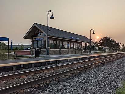
The station has the following entrances: Midlothian Road and Crossing Ave
The first line to this station is UP-NW, at 5:00 AM, and the last line is UP-NW at 1:37 AM.
3001 Midlothian Road, Libertyville, IL, USA
This station serves Metra’s lines
Bus stop near Prairie Crossing
Route 45 & Casey RdPopular public transit stations in Libertyville
79th Street & East End (West),North Ave & Central Park (East),Madison & Franklin (West),Manteno Metro Centre,93rd Street & Paxton (West),Oakton/Northwest Hwy.,Damen & Division (South),95th/Dan Ryan,63rd Street & Rhodes (West),Milwaukee Ave & Olde Half Day Rd/Rt 45,103rd Street & Stony Island Garage Terminal (Se),Bridgeview Transit Center Bay 1,Oak Park Ave & Stanley Ave,Harlem/Touhy,Addison & Western (West),Irving Park & Pulaski (East),1540 W Algonquin Rd,Montrose & Central Park (West),Adams/Wabash,Harlem Ave & 91st StGet around Chicago by public transit!
Traveling around Chicago has never been so easy. See step by step directions as you travel to any attraction, street or major public transit station. View bus and train schedules, arrival times, service alerts and detailed routes on a map, so you know exactly how to get to anywhere in Chicago.
When traveling to any destination around Chicago use Moovit's Live Directions with Get Off Notifications to know exactly where and how far to walk, how long to wait for your line, and how many stops are left. Moovit will alert you when it's time to get off — no need to constantly re-check whether yours is the next stop.
Wondering how to use public transit in Chicago or how to pay for public transit in Chicago? Moovit public transit app can help you navigate your way with public transit easily, and at minimum cost. It includes public transit fees, ticket prices, and costs. Looking for a map of Chicago public transit lines? Moovit public transit app shows all public transit maps in Chicago with all Bus, Train and Chicago 'L' routes and stops on an interactive map.
Chicago has 3 transit type(s), including: Bus, Train and Chicago 'L', operated by several transit agencies, including CTA 'L', Metra, Northern Indiana Commuter Transportation District, CTA, PACE, Gary Public Transit, Amtrak, River Valley Metro, Valpo Transit, DeKalb Public Transit, FlixBus-us, Greyhound-us, Van Galder (Coach USA), Wisconsin Coach Lines