Prenestina/Ponzon stop - Tuesday schedule
| Line | Direction | Time |
|---|---|---|
| N075 | Tonino Bello | 3:29 AM |
| N075 | Tonino Bello | 3:29 AM |
| 508 | Mondavio | 4:08 AM |
| N075 | Tonino Bello | 4:09 AM |
| N075 | Tonino Bello | 4:09 AM |
| 075 | Tonino Bello | 4:35 AM |
| 508 | Mondavio | 4:37 AM |
| N075 | Tonino Bello | 4:49 AM |
| N075 | Tonino Bello | 4:49 AM |
| 508 | Mondavio | 4:59 AM |
| 075 | Tonino Bello | 5:00 AM |
| 051 | Cerquete/Portacannone | 5:12 AM |
| 150F | Tonino Bello | 5:18 AM |
| 508 | Mondavio | 5:19 AM |
| 075 | Tonino Bello | 5:24 AM |
| 051 | Cerquete/Portacannone | 5:28 AM |
| 150F | Tonino Bello | 5:41 AM |
| 508 | Mondavio | 5:42 AM |
| 045 | Ortona Dei Marsi via Montenerodomo | 5:46 AM |
| 051 | Cerquete/Portacannone | 5:46 AM |
| 075 | Tonino Bello | 5:48 AM |
| N075 | Tonino Bello | 5:49 AM |
| N075 | Tonino Bello | 5:49 AM |
| 555 | Pantano (Mc) | 5:50 AM |
| 508 | Mondavio | 6:00 AM |
Directions to Prenestina/Ponzon stop (Roma) with public transit
The following transit lines have routes that pass near Prenestina/Ponzon
 Bus: 051, 150F, 508, 555, COTRAL.
- Metro: C.
How to get to Prenestina/Ponzon stop by bus?
Click on the bus route to see step by step directions with maps, line arrival times and updated time schedules.
Bus stops near Prenestina/Ponzon stop in Roma
- Prenestina/Ponzoni, 1 min walk,
- Prenestina/Riserva Nuova, 9 min walk,
Metro stations near Prenestina/Ponzon station in Roma
- Borghesiana, 37 min walk,
Bus lines to Prenestina/Ponzon stop in Roma
- 045, Casalone - Grotte Celoni (MC),
- 075, Ponte Mammolo (MB) - Colle degli Abeti,
- N075, L.go Preneste - Colle degli Abeti,
- 150F, Flaminio (MA) - Tor Sapienza - Colle degli Abeti,
- 508, Ponte Mammolo (MB) - Prato Fiorito - Giardini di Corcole,
- COTRAL, San Vito Romano - Roma,
- COTRAL, Piglio - Roma Ponte Mammolo,
- COTRAL, Genazzano - Roma Ponte Mammolo,
- COTRAL, Poli - Roma Ponte Mammolo,
- COTRAL, Olevano Romano - Roma Ponte Mammolo,
- COTRAL, Rocca Santo Stefano - Roma Ponte Mammolo,
- 051, Lunghezza (FS) - Colle degli Abeti - Grotte Celoni (MC),
- 555, Ponte di Nona (FS) - Pantano (MC),
- COTRAL, San Vito | Viale Piave,
- COTRAL, Rocca Santo Stefano via Casale,
- COTRAL, Olevano | Via Koch (Terminal),
- COTRAL, Genazzano Depot,
- COTRAL, Bellegra | Via Roma Via San Francesco,
- COTRAL, Roiate | Liberty Square,
- COTRAL, Poli via Piazzale Orziere,
What are the closest stations to Prenestina/Ponzon?
The closest stations to Prenestina/Ponzon are:
- Prenestina/Ponzoni stop is 25 meters away, 1 min walk.
- Prenestina/Riserva Nuova stop is 663 meters away, 9 min walk.
- Borghesiana station is 2888 meters away, 37 min walk.
Which bus lines stop near Prenestina/Ponzon?
These bus lines stop near Prenestina/Ponzon: 051, 150F, 508, 555, COTRAL.
What’s the nearest bus station to Prenestina/Ponzon in Roma?
The nearest bus station to Prenestina/Ponzon in Roma is Prenestina/Ponzoni. It’s a 1 min walk away.
What time is the first metro to Prenestina/Ponzon in Roma?
The C is the first metro that goes to Prenestina/Ponzon in Roma. It stops nearby at 5:32 AM.
What time is the last metro to Prenestina/Ponzon in Roma?
The C is the last metro that goes to Prenestina/Ponzon in Roma. It stops nearby at 12:04 AM.
What time is the first bus to Prenestina/Ponzon in Roma?
The N075 is the first bus that goes to Prenestina/Ponzon in Roma. It stops nearby at 3:04 AM.
What time is the last bus to Prenestina/Ponzon in Roma?
The N075 is the last bus that goes to Prenestina/Ponzon in Roma. It stops nearby at 3:32 AM.
Prenestina/Ponzon station
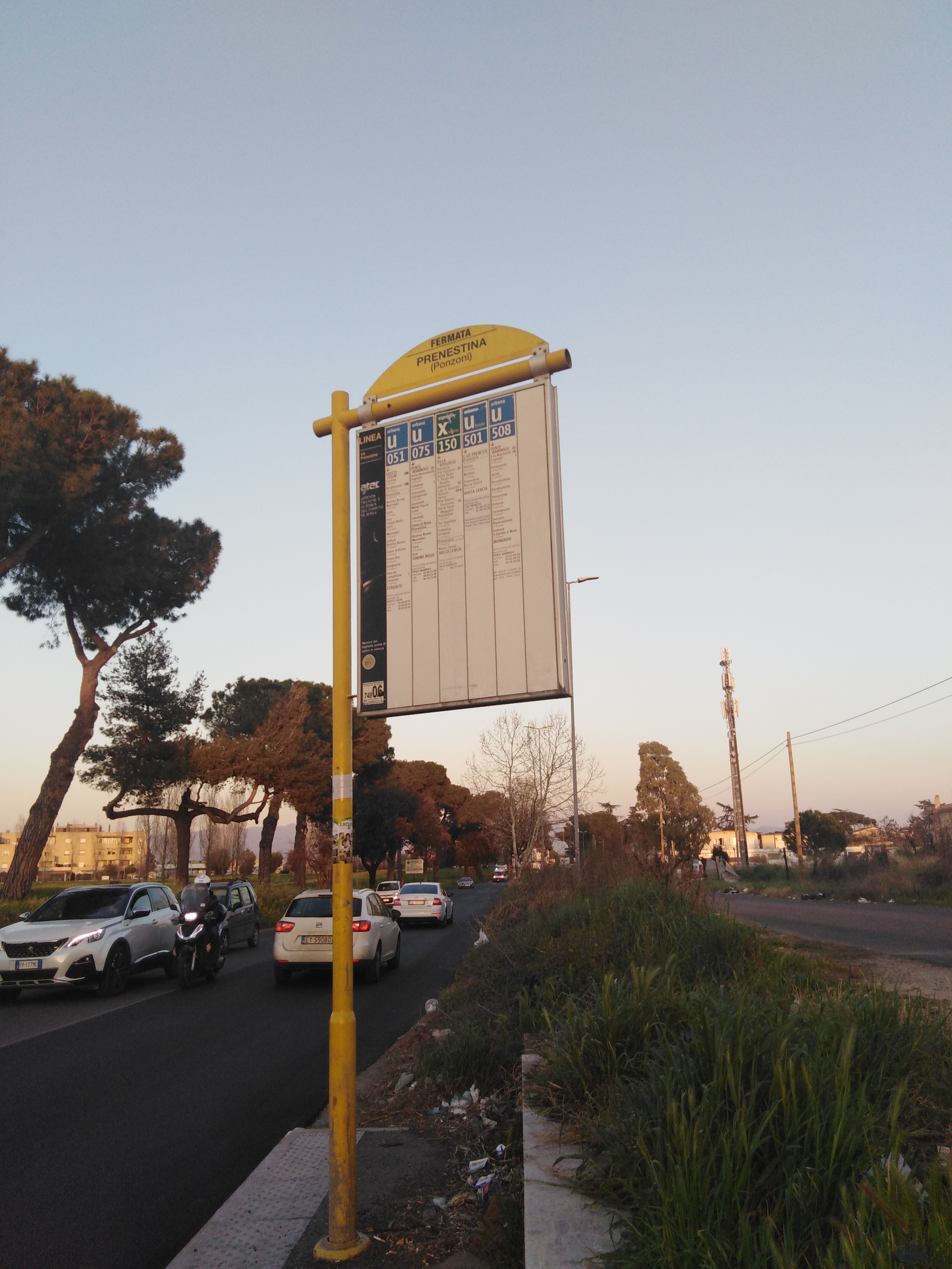 Taken by Romeo E.
See Prenestina/Ponzon stop, Roma, on the map
Public transit to Prenestina/Ponzon stop (ID: 74806) in Roma
Looking for directions to Prenestina/Ponzon in Roma, Italy?
Download the Moovit App to find the current schedule and step-by-step directions for Bus or Metro routes that pass through Prenestina/Ponzon.
Looking for the nearest stops closest to Prenestina/Ponzon ? Check out this list of closest stops to your destination: Prenestina/Ponzoni; Prenestina/Riserva Nuova; Borghesiana.
Bus: 051, 150F, 508, 555, COTRAL, 045, 075, N075.Metro: C.
We make riding on public transit to Prenestina/Ponzon easy, which is why over 1.7 billion users, including users in Roma trust Moovit as the best app for public transit.
Use the app to navigate to popular places including to the airport, hospital, stadium, grocery store, mall, coffee shop, school, college, and university.
Prenestina/Ponzon stop’s code is 74806
The first line to this stop is N075, at 3:29 AM, and the last line is N075 at 2:49 AM.
This stop serves ATAC, Cotral and Troiani Transportation Services’s lines
Popular routes from Prenestina/Ponzon stop, Roma
- Prenestina/Ponzoni,
- Prenestina/Riserva Nuova
Bus stops near Prenestina/Ponzon stop
- Borghesiana
Metro station near Prenestina/Ponzon station
- Sonnino/San Gallicano (Hospital),
- Formia | Appia Street Gianola Street (IPSSEOA),
- Rome San Filippo Neri,
- Herod Atticus/Appia Pignatelli,
- Rome Monte Mario,
- La Rustica U.I.R.,
- Rocca Di Papa,
- Forano | Sports Field,
- Lakes Street,
- Ottavia,
- Vigna Murata (Mb),
- Torre Argentina Street,
- Mentana | 8 September Street,
- Hospital,
- Vittorio Emanuele Course/Argentina,
- Sacred Cave Monastery - Subiaco,
- Piazza Di Porta Maggiore,
- Sezze | Anfiteatro,
- Casale Lumbroso/Fontebasso,
- San Lorenzo Station
Popular public transit stations in Roma
Get around Roma by public transit!
Traveling around Roma has never been so easy. See step by step directions as you travel to any attraction, street or major public transit station. View bus and train schedules, arrival times, service alerts and detailed routes on a map, so you know exactly how to get to anywhere in Roma.
When traveling to any destination around Roma use Moovit's Live Directions with Get Off Notifications to know exactly where and how far to walk, how long to wait for your line, and how many stops are left. Moovit will alert you when it's time to get off — no need to constantly re-check whether yours is the next stop.
Wondering how to use public transit in Roma or how to pay for public transit in Roma? Moovit public transit app can help you navigate your way with public transit easily, and at minimum cost. It includes public transit fees, ticket prices, and costs. Looking for a map of Roma public transit lines? Moovit public transit app shows all public transit maps in Roma with all Bus, Train, Metro, Light Rail, Ferry, Funicular and Gondola routes and stops on an interactive map.
Rome and Lazio has 7 transit type(s), including: Bus, Train, Metro, Light Rail, Ferry, Funicular and Gondola, operated by several transit agencies, including ATAC, Cotral, Trenitalia, Troiani Transportation Services, BIS, ATR Mobility, Tuscia, Shuttle, Seatour, Troiani Bus Lines, CSC Mobility, Terravision, ATRAL, Tambus and Sitbus