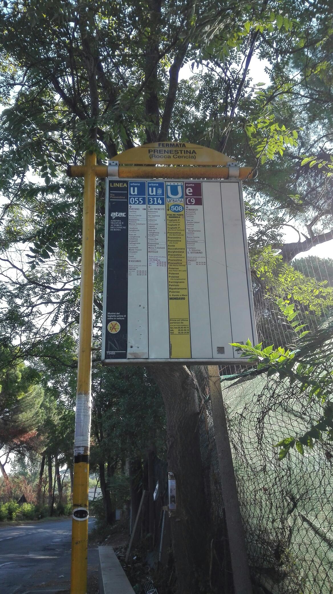
Prenestina/Rocca Cencia stop - Saturday schedule
| Line | Direction | Time |
|---|---|---|
| 508 | Mondavio | 4:15 AM |
| 508 | Mondavio | 4:43 AM |
| 107 | Mondavio | 4:44 AM |
| 055 | D'Ascanio | 5:10 AM |
| 508 | Mondavio | 5:11 AM |
| 107 | Mondavio | 5:12 AM |
| 107 | Mondavio | 5:25 AM |
| 055 | D'Ascanio | 5:32 AM |
| 508 | Mondavio | 5:39 AM |
| 045 | Ortona Dei Marsi via Montenerodomo | 5:47 AM |
| 045 | Grotte Celoni | 5:50 AM |
| 055 | D'Ascanio | 5:52 AM |
| 508 | Mondavio | 6:07 AM |
| 107 | Mondavio | 6:08 AM |
| 055 | D'Ascanio | 6:10 AM |
| 045 | Grotte Celoni | 6:19 AM |
| 508 | Mondavio | 6:21 AM |
| 055 | D'Ascanio | 6:28 AM |
| 045 | Ortona Dei Marsi via Montenerodomo | 6:33 AM |
| 107 | Mondavio | 6:36 AM |
| 314 | Rotello | 6:39 AM |
| 055 | D'Ascanio | 6:46 AM |
| 045 | Grotte Celoni | 6:48 AM |
| 508 | Mondavio | 6:48 AM |
| 314 | Rotello | 7:02 AM |
Directions to Prenestina/Rocca Cencia stop (Roma) with public transit
The following transit lines have routes that pass near Prenestina/Rocca Cencia
 Bus: 045, 055, 107, 314, 555.
- Metro: C.
How to get to Prenestina/Rocca Cencia stop by bus?
Click on the bus route to see step by step directions with maps, line arrival times and updated time schedules.
How to get to Prenestina/Rocca Cencia stop by metro?
Click on the metro route to see step by step directions with maps, line arrival times and updated time schedules.
Bus stops near Prenestina/Rocca Cencia stop in Roma
- Prenestina/Ancient Gabii, 7 min walk,
- Rocca Cencia/AMA Facility, 8 min walk,
- Rome | Prenestina Street Rocca Cencia Street, 11 min walk,
Metro stations near Prenestina/Rocca Cencia station in Roma
- Borghesiana, 39 min walk,
Bus lines to Prenestina/Rocca Cencia stop in Roma
- C9, Alessandrino - San Vittorino,
- 045, Casalone - Grotte Celoni (MC),
- 107, Pantano (Line C) - Tor Bella Monaca - Grotte Celoni (Line C),
- 508, Ponte Mammolo (Metro B) - Giardini di Corcole,
- COTRAL, Roma Ponte Mammolo - Poli,
- 055, Grotte Celoni (MC) - Ponte di Nona,
- 314, Rotello Square - Preneste Square,
- 052, Pantano (Mc),
- 555, Ponte Di Nona (Fl2),
- COTRAL, Rome (Ponte Mammolo),
- COTRAL, San Vito Romano - Roma,
- COTRAL, Piglio - Roma Ponte Mammolo,
- COTRAL, Genazzano - Roma Ponte Mammolo,
- COTRAL, Olevano Romano - Roma Ponte Mammolo,
- COTRAL, Rocca Santo Stefano - Roma Ponte Mammolo,
- COTRAL, Olevano | Via Koch (Terminal),
- COTRAL, Genazzano Depot,
What are the closest stations to Prenestina/Rocca Cencia?
The closest stations to Prenestina/Rocca Cencia are:
- Prenestina/Ancient Gabii stop is 540 meters away, 7 min walk.
- Rocca Cencia/AMA Facility stop is 556 meters away, 8 min walk.
- Rome | Prenestina Street Rocca Cencia Street stop is 851 meters away, 11 min walk.
- Borghesiana station is 3050 meters away, 39 min walk.
Which bus lines stop near Prenestina/Rocca Cencia?
These bus lines stop near Prenestina/Rocca Cencia: 045, 055, 107, 314, 555.
Which metro line stops near Prenestina/Rocca Cencia?
C (Monte Compatri-Pantano)
What’s the nearest bus station to Prenestina/Rocca Cencia in Roma?
The nearest bus station to Prenestina/Rocca Cencia in Roma is Prenestina/Ancient Gabii. It’s a 7 min walk away.
What time is the first metro to Prenestina/Rocca Cencia in Roma?
The C is the first metro that goes to Prenestina/Rocca Cencia in Roma. It stops nearby at 5:30 AM.
What time is the last metro to Prenestina/Rocca Cencia in Roma?
The C is the last metro that goes to Prenestina/Rocca Cencia in Roma. It stops nearby at 12:05 AM.
What time is the first bus to Prenestina/Rocca Cencia in Roma?
The 508 is the first bus that goes to Prenestina/Rocca Cencia in Roma. It stops nearby at 4:13 AM.
What time is the last bus to Prenestina/Rocca Cencia in Roma?
The 314 is the last bus that goes to Prenestina/Rocca Cencia in Roma. It stops nearby at 2:37 AM.
Prenestina/Rocca Cencia station
 Taken by Anonymous
See Prenestina/Rocca Cencia stop, Roma, on the map
Public transit to Prenestina/Rocca Cencia stop (ID: 73488) in Roma
Looking for directions to Prenestina/Rocca Cencia in Roma, Italy?
Download the Moovit App to find the current schedule and step-by-step directions for Bus, Metro or Train routes that pass through Prenestina/Rocca Cencia.
Looking for the nearest stops closest to Prenestina/Rocca Cencia ? Check out this list of closest stops to your destination: Prenestina/Ancient Gabii; Rocca Cencia/AMA Facility; Rome | Prenestina Street Rocca Cencia Street; Borghesiana.
Bus: 045, 055, 107, 314, 555, C9, 508, COTRAL, 052, COTRAL, COTRAL, COTRAL, COTRAL, COTRAL, COTRAL, COTRAL, COTRAL.Metro: C.
We make riding on public transit to Prenestina/Rocca Cencia easy, which is why over 1.7 billion users, including users in Roma trust Moovit as the best app for public transit.
Use the app to navigate to popular places including to the airport, hospital, stadium, grocery store, mall, coffee shop, school, college, and university.
Prenestina/Rocca Cencia stop’s code is 73488
The first line to this stop is 508, at 4:15 AM, and the last line is 314 at 2:37 AM.
This stop serves ATAC, Troiani Transportation Services and Cotral’s lines
- Prenestina/Ancient Gabii,
- Rocca Cencia/AMA Facility,
- Rome | Prenestina Street Rocca Cencia Street
Bus stops near Prenestina/Rocca Cencia stop
- Borghesiana
Metro station near Prenestina/Rocca Cencia station
- Oderisi Da Gubbio/Grimaldi,
- Riano,
- Vittoria Colonna,
- Via Sottocampo 2,
- Aurelia/Richelmy,
- Cittaducale | Railway Station,
- Flaminia/Pantaleoni,
- La Storta,
- Lucio Sestio (MA),
- Newton/Colli Portuensi,
- Lido Center,
- Small Gardens,
- Olevano Romano,
- Gianicolo Pass/Medical Center,
- Tuscolana/Amelia,
- Vittoria Colonna,
- Anzio - 5 Miles Cipriani Road,
- Kant/Marx,
- Tiburtina/Verano,
- Salaria/Aniene
Popular public transit stations in Roma
Get around Roma by public transit!
Traveling around Roma has never been so easy. See step by step directions as you travel to any attraction, street or major public transit station. View bus and train schedules, arrival times, service alerts and detailed routes on a map, so you know exactly how to get to anywhere in Roma.
When traveling to any destination around Roma use Moovit's Live Directions with Get Off Notifications to know exactly where and how far to walk, how long to wait for your line, and how many stops are left. Moovit will alert you when it's time to get off — no need to constantly re-check whether yours is the next stop.
Wondering how to use public transit in Roma or how to pay for public transit in Roma? Moovit public transit app can help you navigate your way with public transit easily, and at minimum cost. It includes public transit fees, ticket prices, and costs. Looking for a map of Roma public transit lines? Moovit public transit app shows all public transit maps in Roma with all Bus, Train, Metro, Light Rail, Ferry, Funicular and Gondola routes and stops on an interactive map.
Rome and Lazio has 7 transit type(s), including: Bus, Train, Metro, Light Rail, Ferry, Funicular and Gondola, operated by several transit agencies, including ATAC, Cotral, Trenitalia, Troiani Transportation Services, BIS, ATR Mobility, Tuscia, Shuttle, Seatour, Troiani Bus Lines, CSC Mobility, Terravision, ATRAL, Tambus and Sitbus