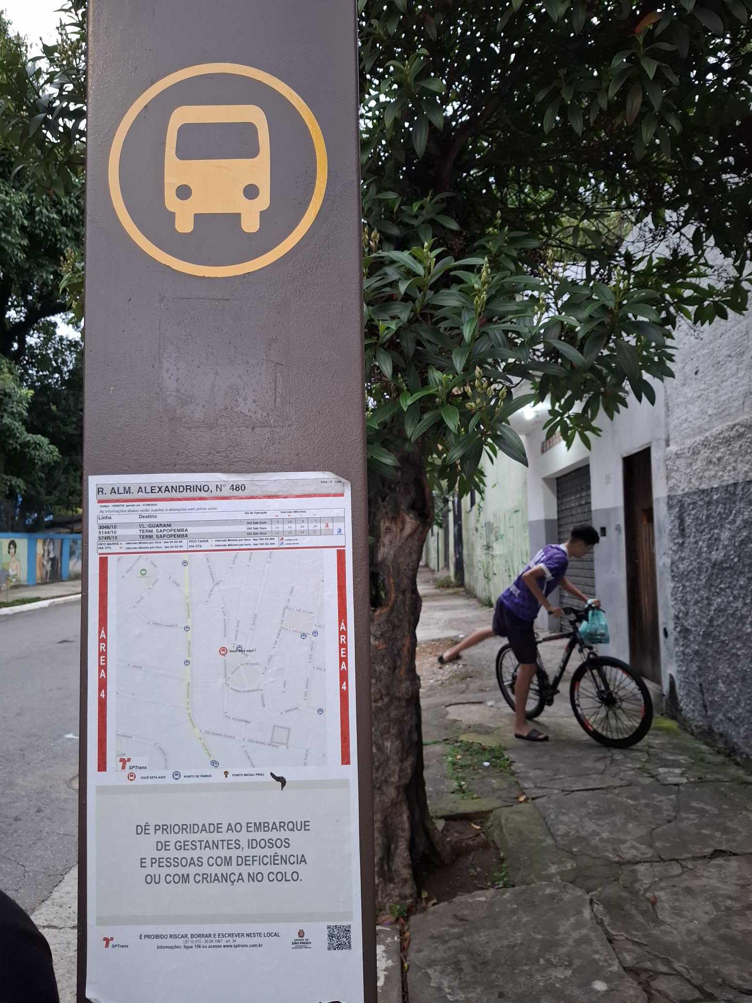
R. Alm. Alexandrino, 480 stop - Wednesday schedule
| Line | Direction | Time |
|---|---|---|
| 574R-10 | Term. Sapopemba | 5:00 AM |
| 3046-10 | Vl. Guarani | 5:21 AM |
| 574R-10 | Term. Sapopemba | 5:21 AM |
| 3046-10 | Vl. Guarani | 5:29 AM |
| 5144-10 | Term. Sapopemba | 5:32 AM |
| 574R-10 | Term. Sapopemba | 5:36 AM |
| 3046-10 | Vl. Guarani | 5:37 AM |
| 3046-10 | Vl. Guarani | 5:45 AM |
| 574R-10 | Term. Sapopemba | 5:51 AM |
| 3046-10 | Vl. Guarani | 5:53 AM |
| 3046-10 | Vl. Guarani | 6:01 AM |
| 3046-10 | Vl. Guarani | 6:08 AM |
| 574R-10 | Term. Sapopemba | 6:11 AM |
| 3046-10 | Vl. Guarani | 6:17 AM |
| 3046-10 | Vl. Guarani | 6:23 AM |
| 5144-10 | Term. Sapopemba | 6:23 AM |
| 574R-10 | Term. Sapopemba | 6:26 AM |
| 3046-10 | Vl. Guarani | 6:30 AM |
| 574R-10 | Term. Sapopemba | 6:36 AM |
| 3046-10 | Vl. Guarani | 6:37 AM |
| 3046-10 | Vl. Guarani | 6:44 AM |
| 574R-10 | Term. Sapopemba | 6:46 AM |
| 3046-10 | Vl. Guarani | 6:50 AM |
| 3046-10 | Vl. Guarani | 6:56 AM |
| 574R-10 | Term. Sapopemba | 6:56 AM |
Directions to R. Alm. Alexandrino, 480 stop (Água Rasa) with public transit
The following transit lines have routes that pass near R. Alm. Alexandrino, 480
 Bus: 3046-10, 3134-10, 5144-10, 574R-10, N503-11.
- Metro: LINHA 15, LINHA 2.
- Train: LINHA 10, LINHA 2.
How to get to R. Alm. Alexandrino, 480 stop by bus?
Click on the bus route to see step by step directions with maps, line arrival times and updated time schedules.
How to get to R. Alm. Alexandrino, 480 stop by train?
Click on the train route to see step by step directions with maps, line arrival times and updated time schedules.
How to get to R. Alm. Alexandrino, 480 stop by metro?
Click on the metro route to see step by step directions with maps, line arrival times and updated time schedules.
Bus stops near R. Alm. Alexandrino, 480 stop in Água Rasa
- R. Marumbi, 1 min walk,
- Av. Sapopemba, 1952, 6 min walk,
- Av. Adutora do Rio Claro, 26, 7 min walk,
Train stations near R. Alm. Alexandrino, 480 station in Água Rasa
- Tamanduateí, 36 min walk,
Metro stations near R. Alm. Alexandrino, 480 station in Água Rasa
- São Lucas, 46 min walk,
Bus lines to R. Alm. Alexandrino, 480 stop in Água Rasa
- 574R-10, Metrô Belém,
- 3046-10, Vl. Guarani,
- 5144-10, Term. Princ. Isabel,
- N503-11, Term. Pq. D. Pedro II,
- 3141-10, São Mateus,
- 4729-10, Metrô Belém,
- 5141-10, Pça. do Correio,
- 407Y-10, Metrô Vl. Prudente,
- 573H-10, Metrô Bresser,
- 574J-10, Metrô Conceição,
- 3134-10, Metrô Tamanduateí,
- 3161-10, Term. Pq. D. Pedro II,
- 5145-10, Term. Sapopemba,
What are the closest stations to R. Alm. Alexandrino, 480?
The closest stations to R. Alm. Alexandrino, 480 are:
- R. Marumbi stop is 42 meters away, 1 min walk.
- Av. Sapopemba, 1952 stop is 434 meters away, 6 min walk.
- Av. Adutora do Rio Claro, 26 stop is 528 meters away, 7 min walk.
- Tamanduateí station is 2826 meters away, 36 min walk.
- São Lucas station is 3583 meters away, 46 min walk.
Which bus lines stop near R. Alm. Alexandrino, 480?
These bus lines stop near R. Alm. Alexandrino, 480: 3046-10, 3134-10, 5144-10, 574R-10.
Which metro lines stop near R. Alm. Alexandrino, 480?
These metro lines stop near R. Alm. Alexandrino, 480: LINHA 15, LINHA 2.
Which train line stops near R. Alm. Alexandrino, 480?
LINHA 10 (Luz (Expresso +))
What’s the nearest bus station to R. Alm. Alexandrino, 480 in Água Rasa?
The nearest bus station to R. Alm. Alexandrino, 480 in Água Rasa is R. Marumbi. It’s a 1 min walk away.
What time is the first metro to R. Alm. Alexandrino, 480 in Água Rasa?
The LINHA 2 is the first metro that goes to R. Alm. Alexandrino, 480 in Água Rasa. It stops nearby at 4:40 AM.
What time is the last metro to R. Alm. Alexandrino, 480 in Água Rasa?
The LINHA 15 is the last metro that goes to R. Alm. Alexandrino, 480 in Água Rasa. It stops nearby at 12:26 AM.
What time is the first train to R. Alm. Alexandrino, 480 in Água Rasa?
The LINHA 10 is the first train that goes to R. Alm. Alexandrino, 480 in Água Rasa. It stops nearby at 4:13 AM.
What time is the last train to R. Alm. Alexandrino, 480 in Água Rasa?
The LINHA 10 is the last train that goes to R. Alm. Alexandrino, 480 in Água Rasa. It stops nearby at 12:37 AM.
What time is the first bus to R. Alm. Alexandrino, 480 in Água Rasa?
The N503-11 is the first bus that goes to R. Alm. Alexandrino, 480 in Água Rasa. It stops nearby at 3:15 AM.
What time is the last bus to R. Alm. Alexandrino, 480 in Água Rasa?
The N503-11 is the last bus that goes to R. Alm. Alexandrino, 480 in Água Rasa. It stops nearby at 3:19 AM.
R. Alm. Alexandrino, 480 station
 Taken by Anonymous
See R. Alm. Alexandrino, 480 stop, Água Rasa, on the map
Public transit to R. Alm. Alexandrino, 480 stop in Água Rasa
Looking for directions to R. Alm. Alexandrino, 480 in Água Rasa, Brazil?
Download the Moovit App to find the current schedule and step-by-step directions for Bus, Metro or Train routes that pass through R. Alm. Alexandrino, 480.
Looking for the nearest stops closest to R. Alm. Alexandrino, 480 ? Check out this list of closest stops to your destination: R. Marumbi; Av. Sapopemba; Av. Adutora do Rio Claro; Tamanduateí; São Lucas.
Bus: 3046-10, 3134-10, 5144-10, 574R-10, N503-11, 3141-10, 4729-10, 5141-10, 407Y-10, 573H-10, 574J-10, 3161-10.Metro: LINHA 15, LINHA 2.Train: LINHA 10, LINHA 2.
We make riding on public transit to R. Alm. Alexandrino, 480 easy, which is why over 1.7 billion users, including users in Água Rasa trust Moovit as the best app for public transit.
Use the app to navigate to popular places including to the airport, hospital, stadium, grocery store, mall, coffee shop, school, college, and university.
The first line to this stop is 574R-10, at 5:00 AM, and the last line is 5144-10 at 1:10 AM.
616 Rua Almirante Alexandrino, São Paulo, Brazil
This stop serves SPTrans’s lines
- R. Marumbi,
- Av. Sapopemba, 1952,
- Av. Adutora do Rio Claro, 26
Bus stops near R. Alm. Alexandrino, 480 stop
- Tamanduateí
Train station near R. Alm. Alexandrino, 480 station
- São Lucas
Metro station near R. Alm. Alexandrino, 480 station
- Rua Coronel Xavier de Toledo, 220,
- Villa Lobos-Jaguaré,
- Jandira,
- Av. Mutinga, 4978 - Jardim Santo Elias, São Paulo,
- Avenida Ayrton Senna,
- Av. Miguel Achiole da Fonseca,
- Vila Olímpia,
- R. Card. Arcoverde, 950,
- Av. Inconfidência Mineira, 2050,
- Av. Tiradentes, 615,
- Av. Magalhães de Castro,
- Água Branca,
- Av. Nicolau Jacinto, 685,
- Av. Campanella,
- Ave. Morvan Dias de Figueiredo 2801,
- R. Voluntários da Pátria, 3744,
- Marechal Deodoro,
- R. Maria Paula, 53,
- Rua Vereda Tropical, 186,
- Av. Prof. Luiz Ignácio Anhaia Mello, 4900
Popular public transit stations in Água Rasa
Get around Água Rasa by public transit!
Traveling around Água Rasa has never been so easy. See step by step directions as you travel to any attraction, street or major public transit station. View bus and train schedules, arrival times, service alerts and detailed routes on a map, so you know exactly how to get to anywhere in Água Rasa.
When traveling to any destination around Água Rasa use Moovit's Live Directions with Get Off Notifications to know exactly where and how far to walk, how long to wait for your line, and how many stops are left. Moovit will alert you when it's time to get off — no need to constantly re-check whether yours is the next stop.
Wondering how to use public transit in Água Rasa or how to pay for public transit in Água Rasa? Moovit public transit app can help you navigate your way with public transit easily, and at minimum cost. It includes public transit fees, ticket prices, and costs. Looking for a map of Água Rasa public transit lines? Moovit public transit app shows all public transit maps in Água Rasa with all Bus, Train, Metro, Light Rail, Ferry, Gondola, Cable Car and Funicular routes and stops on an interactive map.
Sao Paulo Region has 8 transit type(s), including: Bus, Train, Metro, Light Rail, Ferry, Gondola, Cable Car and Funicular, operated by several transit agencies, including SPTrans, CPTM, ViaMobilidade, Aquático SP, SPTRANS, EMTU, ViaQuatro, Auto Ônibus Moratense, GRU Airport (Aeroporto de Guarulhos), Auto Viação Urubupungá (Cajamar), Viação Cometa, Auto Viação Urubupungá (Osasco), Viação Ultra / Rápido Brasil, Auto Viação Urubupungá (Santana de Parnaíba) and Expresso Luxo