R. Domingos de Morais, 3088 stop - Thursday schedule
| Line | Direction | Time |
|---|---|---|
| N604-11 | Metrô Jabaquara | 3:27 AM |
| N604-11 | Metrô Jabaquara | 4:12 AM |
| N604-11 | Metrô Jabaquara | 4:27 AM |
| 5123-10 | Jd. Miriam | 5:15 AM |
| 4718-10 | Metrô Sta. Cruz | 5:16 AM |
| 4716-10 | Metrô Tamanduateí | 5:25 AM |
| 875A-10 | Aeroporto | 5:25 AM |
| 5123-10 | Jd. Miriam | 5:35 AM |
| 5164-21 | Pq. Ibirapuera | 5:39 AM |
| 5164-10 | Pq. Ibirapuera | 5:43 AM |
| 4716-10 | Metrô Tamanduateí | 5:45 AM |
| 5791-10 | Eldorado | 5:47 AM |
| 4718-10 | Metrô Sta. Cruz | 5:49 AM |
| 5290-10 | Div. Diadema | 5:49 AM |
| 574A-10 | Americanópolis | 5:53 AM |
| 5123-10 | Jd. Miriam | 5:55 AM |
| 5106-10 | Mar Paulista | 5:57 AM |
| 875A-10 | Aeroporto | 5:57 AM |
| 5164-10 | Pq. Ibirapuera | 6:00 AM |
| 5164-21 | Pq. Ibirapuera | 6:00 AM |
| 4716-10 | Metrô Tamanduateí | 6:01 AM |
| 5791-10 | Eldorado | 6:07 AM |
| 574A-10 | Americanópolis | 6:08 AM |
| 5123-10 | Jd. Miriam | 6:10 AM |
| 5290-10 | Div. Diadema | 6:14 AM |
Directions to R. Domingos de Morais, 3088 stop (Saúde) with public transit
The following transit lines have routes that pass near R. Domingos de Morais, 3088
 Bus: 502J-10, 5164-21, 5290-10, 574A-10, 6338-10.
- Metro: LINHA 1, LINHA 5, LINHA 2.
How to get to R. Domingos de Morais, 3088 stop by bus?
Click on the bus route to see step by step directions with maps, line arrival times and updated time schedules.
How to get to R. Domingos de Morais, 3088 stop by metro?
Click on the metro route to see step by step directions with maps, line arrival times and updated time schedules.
Bus stops near R. Domingos de Morais, 3088 stop in Saúde
- R. Domingos de Morais, 3015, 2 min walk,
- Av. Jabaquara, 79, 3 min walk,
- Rua Loefgreen, 1057 - Metrô Santa Cruz, 7 min walk,
Metro stations near R. Domingos de Morais, 3088 station in Saúde
- Vila Mariana, 8 min walk,
- Chácara Klabin, 13 min walk,
Bus lines to R. Domingos de Morais, 3088 stop in Saúde
- 574A-10, Americanópolis - Largo Cambuci,
- 574A-21, Americanópolis - Metrô Vila Mariana,
- N604-11, Metrô Jabaquara - Terminal Parque Dom Pedro Ii,
- 875A-10, Aeroporto - Perdizes,
- 5106-10, Mar Paulista - Largo São Francisco,
- 5290-10, Domv. Domadema - Terminal Parque Dom Pedro Ii,
- 5791-10, Eldorado - Metrô Vergueiro,
- 475R-10, Jardim São Savério - Terminal Parque Dom Pedro Ii,
- 502J-10, Estação Autódromo - Metrô Santa Cruz,
- 577T-10, Jardim Miriam - Metrô Ana Rosa,
- 4716-10, Metrô Tamanduateí - Metrô Santa Cruz,
- 4718-10, Jardim Celeste - Metrô Santa Cruz (Circular),
- 5123-10, Jardim Miriam - Hospital São Paulo,
- 5164-10, Vila Santa Catarina - Parque Ibirapuera (Circular),
- 5164-21, Cidade Leonor - Parque Ibirapuera (Circular),
- 6338-10, Jardim Miriam - Parque Ibirapuera (Circular),
- 476A-10, Term. Sto. Amaro,
- N505-11, Term. Pinheiros,
- 5103-10, Moema,
What are the closest stations to R. Domingos de Morais, 3088?
The closest stations to R. Domingos de Morais, 3088 are:
- R. Domingos de Morais, 3015 stop is 115 meters away, 2 min walk.
- Av. Jabaquara, 79 stop is 147 meters away, 3 min walk.
- Rua Loefgreen, 1057 - Metrô Santa Cruz stop is 517 meters away, 7 min walk.
- Vila Mariana station is 590 meters away, 8 min walk.
- Chácara Klabin station is 972 meters away, 13 min walk.
Which bus lines stop near R. Domingos de Morais, 3088?
These bus lines stop near R. Domingos de Morais, 3088: 502J-10, 5164-21, 5290-10, 574A-10, 6338-10, 875A-10.
Which metro lines stop near R. Domingos de Morais, 3088?
These metro lines stop near R. Domingos de Morais, 3088: LINHA 1, LINHA 5.
What’s the nearest metro station to R. Domingos de Morais, 3088 in Saúde?
The nearest metro station to R. Domingos de Morais, 3088 in Saúde is Vila Mariana. It’s a 8 min walk away.
What’s the nearest bus station to R. Domingos de Morais, 3088 in Saúde?
The nearest bus station to R. Domingos de Morais, 3088 in Saúde is R. Domingos de Morais, 3015. It’s a 2 min walk away.
What time is the first metro to R. Domingos de Morais, 3088 in Saúde?
The LINHA 5 is the first metro that goes to R. Domingos de Morais, 3088 in Saúde. It stops nearby at 4:40 AM.
What time is the last metro to R. Domingos de Morais, 3088 in Saúde?
The LINHA 1 is the last metro that goes to R. Domingos de Morais, 3088 in Saúde. It stops nearby at 12:35 AM.
What time is the first bus to R. Domingos de Morais, 3088 in Saúde?
The N505-11 is the first bus that goes to R. Domingos de Morais, 3088 in Saúde. It stops nearby at 3:16 AM.
What time is the last bus to R. Domingos de Morais, 3088 in Saúde?
The N604-11 is the last bus that goes to R. Domingos de Morais, 3088 in Saúde. It stops nearby at 2:58 AM.
R. Domingos de Morais, 3088 station
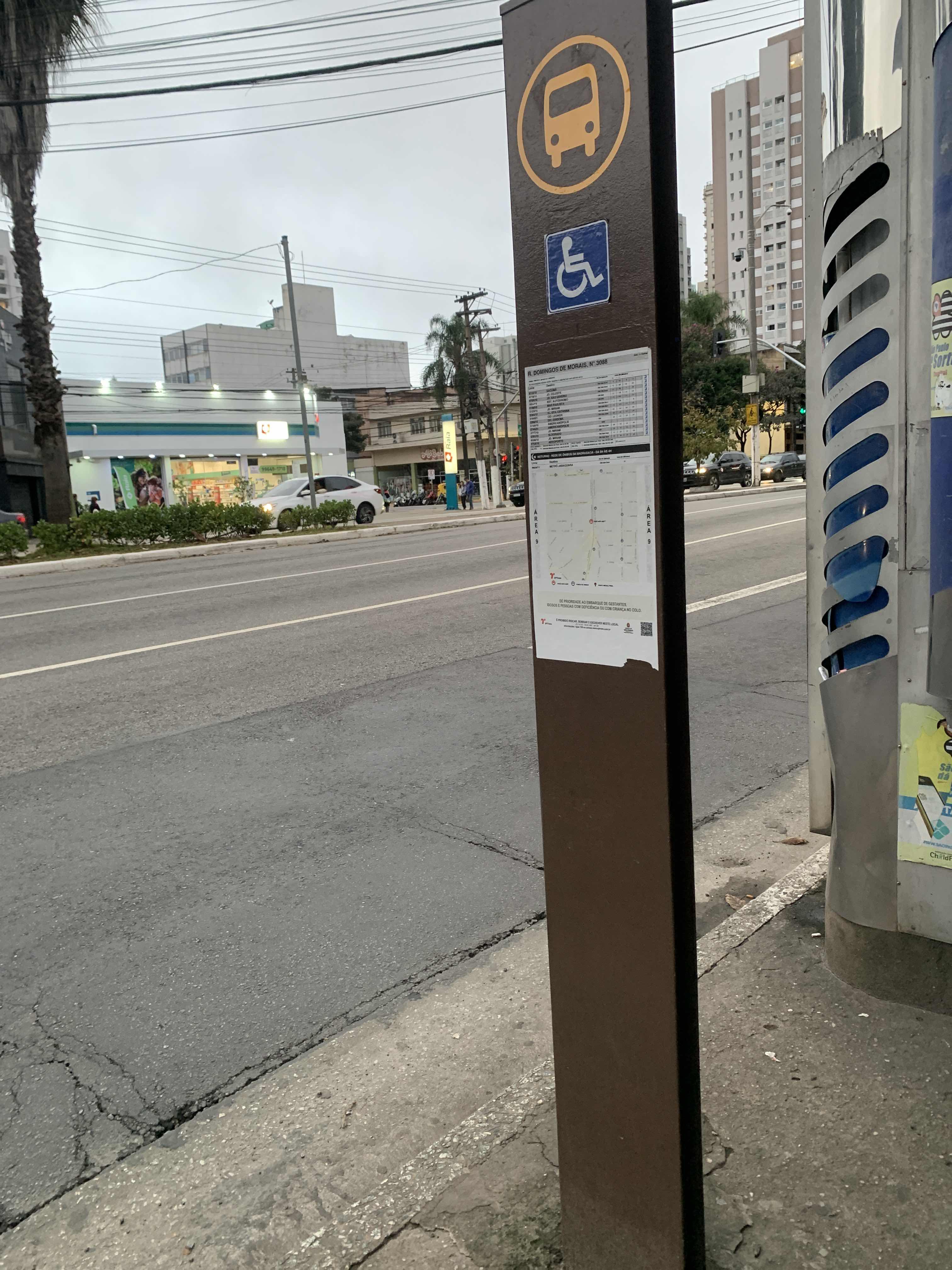 Taken by Anonymous
See R. Domingos de Morais, 3088 stop, Saúde, on the map
Public transit to R. Domingos de Morais, 3088 stop in Saúde
Looking for directions to R. Domingos de Morais, 3088 in Saúde, Brazil?
Download the Moovit App to find the current schedule and step-by-step directions for Bus, Metro or Train routes that pass through R. Domingos de Morais, 3088.
Looking for the nearest stops closest to R. Domingos de Morais, 3088 ? Check out this list of closest stops to your destination: R. Domingos de Morais; Av. Jabaquara; Rua Loefgreen; Vila Mariana; Chácara Klabin.
Bus: 502J-10, 5164-21, 5290-10, 574A-10, 6338-10, 875A-10, 574A-21, N604-11, 5106-10, 475R-10, 577T-10, 4716-10, 4718-10, 476A-10, N505-11, 5103-10.Metro: LINHA 1, LINHA 5, LINHA 2.
We make riding on public transit to R. Domingos de Morais, 3088 easy, which is why over 1.7 billion users, including users in Saúde trust Moovit as the best app for public transit.
Use the app to navigate to popular places including to the airport, hospital, stadium, grocery store, mall, coffee shop, school, college, and university.
The first line to this stop is N604-11, at 3:27 AM, and the last line is N604-11 at 2:57 AM.
3087 Rua Domingos de Morais, São Paulo, Brazil
This stop serves SPTrans’s lines
- R. Domingos de Morais, 3015,
- Av. Jabaquara, 79,
- Rua Loefgreen, 1057 - Metrô Santa Cruz
Bus stops near R. Domingos de Morais, 3088 stop
- Vila Mariana,
- Chácara Klabin
Metro stations near R. Domingos de Morais, 3088 station
- R. Francisco Fanganiello, 127,
- Rod. Pres. Dutra Km 221 - Posto Carreteiro,
- R. Scipião, 67,
- Avenida Deputado Emílio Carlos, 3902,
- Japão-Liberdade,
- Ponto Final,
- Parada Inglesa,
- Av. Cruzeiro do Sul, 2867,
- Av. Ricardo Jafet, 1550,
- Av. Osvaldo Valle Cordeiro, 389,
- Estrada Municipal Do Lambari (Congregacao Crista No Brasil),
- Av. Miguel Achiole da Fonseca,
- Rua Padre Álvaro Quinhones Zuniga 474,
- Av. Jaceguava,
- Terminal Mercado,
- Carrão-Assaí Atacadista,
- Rua da Bica, 285 - Jardim Belval, Barueri,
- Butantã,
- Av. Morumbi, 8860,
- R. João Ventura Batista, 615
Popular public transit stations in Saúde
Get around Saúde by public transit!
Traveling around Saúde has never been so easy. See step by step directions as you travel to any attraction, street or major public transit station. View bus and train schedules, arrival times, service alerts and detailed routes on a map, so you know exactly how to get to anywhere in Saúde.
When traveling to any destination around Saúde use Moovit's Live Directions with Get Off Notifications to know exactly where and how far to walk, how long to wait for your line, and how many stops are left. Moovit will alert you when it's time to get off — no need to constantly re-check whether yours is the next stop.
Wondering how to use public transit in Saúde or how to pay for public transit in Saúde? Moovit public transit app can help you navigate your way with public transit easily, and at minimum cost. It includes public transit fees, ticket prices, and costs. Looking for a map of Saúde public transit lines? Moovit public transit app shows all public transit maps in Saúde with all Bus, Train, Metro, Light Rail, Ferry, Gondola, Cable Car and Funicular routes and stops on an interactive map.
Sao Paulo Region has 8 transit type(s), including: Bus, Train, Metro, Light Rail, Ferry, Gondola, Cable Car and Funicular, operated by several transit agencies, including SPTrans, CPTM, ViaMobilidade, Aquático SP, SPTRANS, EMTU, ViaQuatro, Auto Ônibus Moratense, GRU Airport (Aeroporto de Guarulhos), Auto Viação Urubupungá (Cajamar), Viação Cometa, Auto Viação Urubupungá (Osasco), Viação Ultra / Rápido Brasil, Auto Viação Urubupungá (Santana de Parnaíba) and Expresso Luxo